The days leading up to the climb...
Only a couple of days away from our trip to Mount Shasta! I was both excited and a little nervous. I had barely digested my failure to summit Middle Palisade a week earlier and yet another 14’er was coming up. I wasn’t sure if I was ready to take on this huge Cascade volcano. I did prepare a lot better than for the Middle Pal climb. I kept my weight under control (I gained 5 pounds right before the previous trip) and worked on my condition and acclimatization. I hike up to San Gorgonio (11,500 feet) via the 22-mile Fish Creek trail the weekend before and went on two intense 20-mile bike rides. Now I could only hope the weather would cooperate. It sure looked like it as the forecast was calling for ‘mostly sunny’ skies, wohow!!
Thursday came and I discussed the last specifics with
Scott, who had suggested to take this trip. We would meet Scott in Stockton, CA and drive together from there. Scott had attempted Shasta from the Hotlum-Bolam ridge a few years earlier but aborted when his guides had to intervene in a rescue of a climber who made a fatal fall (http://www.shastaavalanche.org/accident.htm - see 9-23-00 at the bottom of the page).
We quickly packed Thursday evening and picked up our small rental car; a wise decision with the expensive gas prices these days.
Friday July 14th
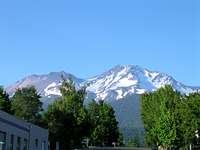
6:00am, the alarm went off. Chrissy and I hurried out of bed and we were on the road by 6:30am. Luckily LA traffic was light and we made good progress on our way to Stockton where we met up with Scott. We dumped our car for the weekend and drove together to Mount Shasta. A couple of hours later the mountain made its appearance at the horizon. I was immediately impressed by its sheer size! Hard to believe people could make it to the top of it!
Once we made it to the small town of Mount Shasta, we loaded up on carbs in a local Italian restaurant, which had the atmosphere as if time had been standing still for a couple of years; it was quite a pleasant change from the busy life in SoCal.
A little past 7pm we drove up the road to Bunny Flat where we would crash for the night. We got our wilderness permit and summit pass and decided to take a little evening walk up the trail. We met several parties coming down that looked seriously beat up! Either they weren’t prepared or the Avalanche Gulch is not an easy climb!
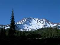
Night time came and we were ready for bed. I didn’t bother setting up my tent; the skies were clear and the temperature was pleasant. Getting comfortable in my warm sleeping bag, I soon fell asleep. Around 1am I woke up and thought the headlights of a car were shining in my face. I looked up to an almost full moon! Shasta couldn’t look better in the moonlight surrounded by countless stars. I admired the view for a while and went back to sleep.
Saturday July 15th
We woke up around 6:30am. After some breakfast and a quick run back into town to pick up some glacier glasses for Chrissy and Scott, we were on our way! The hike was pretty fast and uneventful; soon we made it to Horse Camp (7900feet) where we paid a visit to the Sierra Club hut and filled up with the so-called ‘purest water in the world’ from the spring. From Horse camp, we could continue mostly on the rocks to the left of the gulch. Some people were climbing the snow but they moved way slower; moreover the sun reflection probably made it horribly hot; rocks were the way to go! A little past noon we already arrived at our destination for the day: 50/50; a camping spot about halfway the distance to the summit at about 9400 feet.
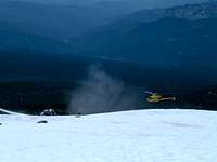
We occupied the higher camping spots as a rescue helicopter was landing on the lower site to pick up an unfortunate climber. Overnight he had developed a severe form of altitude sickness at Helen Lake; kind of weird at such a low elevation (10400 feet)...
We spent the rest of the day chatting with other climbers about their Shasta adventure. I also made a glissade path and we had some fun self-arresting and glissading in the snow. Later in the afternoon we started boiling snow for water. Boy, did that take a long time! Luckily we brought enough gas!
In the meantime we discussed our plan of attack for the next day. We decided to wake up at 2am to avoid the rock fall and to have firm snow conditions. Staying to the far right of the Heart (a rocky area under the Red Banks) and making the traverse on the Red Banks (=red ‘canyon-looking’ rocks at 12800 feet) between the Thumb and the Banks seemed the easiest and safest.
Scott felt a little out of his element on this big mountain and decided not to climb with us in the morning. Only 4 weeks later he was getting married and didn’t want to take any chances. On his last attempt a climber died and now there was another rescue; maybe not a good sign… I had no doubt in my mind he could make it (heck, he finished an Iron Man before) but if it doesn’t feel right…
He gave us his full support to make the summit attempt and we would meet him back at the trailhead the next day.
After we got all our gear ready, we went to bed around 7pm.
Sunday July 16th
I had woken up around midnight and didn’t sleep a whole lot after that. So, I pretty much waited for the 2am alarm to go off. There it was! Ready to go! Well, maybe not that fast… It wasn’t all that great to get out of the warm sleeping bag. It was pretty chilly and windy outside. I did manage to get myself out there and started boiling water for our breakfast. As I burn food faster than a Hummer does fuel, I made a double serving of spaghetti and pretty much finished it; it was surprisingly tasty at 2am! Chrissy ate her oatmeal and we geared up. As we saw 2 tents completely flattened by the rescue helicopter the day before, we decided to put ours down and secure it with heavy rocks.
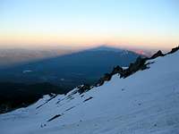
3:30am: finally ready to go! I stepped on the snow at it was nice and firm; awesome! I felt pretty strong we passed a couple of parties on our way to Helen Lake (10400’). After a little break we started our ascent to the Red Banks. It’s a steep 2800 foot snowfield from here. We went a little slower here; we didn’t want to wear ourselves out and gain elevation too fast (I tend to get sick if I do that). About halfway up, we could turn off our headlamps and I could see the giant shadow of the mountain under the first sunlight; what an impressive sight!
![Mt. Shasta shadow]()
Shortly after that I took a quick food break on some rocks next to the snowfield. From there on we could follow nicely kicked-in steps all the way to the Red Banks. That’s were I first noticed the altitude and I got a small head ache. I knew it was time to slow down; Chrissy didn’t seem to be affected and continued up ahead of me. The traverse to the Red Banks was really easy and soon we were having lunch (well, it felt like lunch although it was only somewhere around 8am). We met a couple of people on our way up and had a little chat.
The route ahead was pretty straightforward now; climb up walking on top of the Banks and towards Misery Hill; which wasn’t all that much ‘misery’. That’s also where we met
Keisha. Her 2 climbing partners bailed at the Red Banks but she still wanted to continue, so we ‘adopted’ her and enjoyed each others company.
Once on top of Misery Hill, I was a little frustrated to see the summit was still a decent walk across the summit plateau. I guess I was more mentally prepared for Misery Hill and didn’t count on that last part. Either way, the summit was a fact now. We hiked across the plateau and climbed up the rocks and there we were; 14162 feet (4317m) above sea level! The views in either direction were absolutely phenomenal! We signed the summit register and had the mandatory summit pics. Standing on the summit block looking down definitely gives an adrenaline rush!
![On top of Shasta!]()
At 11:45am, we headed back down. Apart from the loose rock on the Red Banks, the hike down was pretty easy. We crossed the Kowakiton glacier back towards the Thumb and scrambled down a little ways towards the snow where we would glissade down. On the way up, I had my thoughts about sliding down this steep hill; it seemed pretty scary! Keisha and Chrissy went first as I was the only one confident enough to make a fast stop if necessary (and not knock somebody out). Then it was my turn to glissade down. The snow was perfect! You could pick up some serious speed but brake just by digging in your heels in the snow. Being pretty hot by now, it felt refreshing! It was awesome seeing the snow fly up 4-5 feet in the air while braking. We probably made it down to Helen Lake in under 30min (otherwise a 2-3 hour climb).
After saying goodbye to Keisha and exchanging contact info, we glissaded further down, packed up our tent and glissaded some more towards Horse Camp. After filling up with water at Horse Camp, we made it back to the trailhead around 6pm. A long but very satisfying day! From there we headed to Redding to have some food at the Black Bear diner and crash at our motel.
For anybody going out there, Shasta is some serious FUN!!
For more pictures, surf to:
http://s43.photobucket.com/albums/e378/luciano136/Other%20-%20Hikes-Mountains/CA%20-%20Mt%20Shasta%20-%20Jul15-16%202006/


Comments
Post a Comment