Intro
There's a special moment that comes at the transition between stages in life where you sit back, reflect, and try to burn one last image of the past into your mind. You've gone for your last run through the neighborhood, eaten your last meal, and raised your last glass with your buddies. Your gear is packed, except for those few last things - the toothbrush, the pillow, a change of clothes for the morning. You pause, look around, take a deep breath, and soak it all in.
So far, that moment of reflective clarity has escaped me. On Friday I packed my desk, got my final paycheck, said my goodbyes, and dodged traffic on 101 from Redwood City to Mountain View one last time. I spent the weekend relaxing and prepping for my trip to Shasta. In two weeks I'm driving to Yosemite, on to Glacier NP for a Wilderness EMT class, and then to the Cascades for several weeks of mountaineering. From there it's the Sierras, the Bugaboos, the Tetons, the canyons of the Southwest, and any other territory west of the Mississippi I can get my hands on. But right now, watching the sun set from 10,300 feet up Mt Shasta, I feel like I'm on just another weekend mountaineering trip.
Nice Try
I'd tried to climb Shasta twice before, both via Casaval Ridge. In 2005, my roommate Joe and I drove up on a Friday night, stopping for pizza and milkshakes at Granzellas and arriving at Bunny Flat around midnight. After an uncomfortable hour of fake sleep in the front seats of his S4, we sorted gear and took off. Trying to make sure we didn't burn out, we kept an easy but solid pace up the ridge past 10,000' camp to first window, where Casaval joins another ridge and you get your first real view of the upper route.
We switched to crampons and began the traverse below the gendarmes by headlamp. I don't remember when the sun came up, but I do remember our pace slackening as the slope got steeper. It was cold and windy, and we finally found shelter in a snow hollow around a rock as another group caught us. We were immediately below the hourglass in the prominent diagonal rock band that joins Casaval, but for reasons now unclear we thought we were much higher. There was a thin band of snow that cut right, and mistaking it for the catwalk we followed it.
A scary traverse above a scree chute dumped us out in Avalanche Gulch, where we immediately realized our mistake. A quick time check revealed that it was 11AM, and we both knew the trip was hosed. For me, at least, the prior night's lack of sleep had finally taken its toll. We glissaded down as rock and ice balls rolled by in the warming weather, ate the leftover pizza we'd packed for the summit, and snowshoed out to the car.
Return 2 Casaval
![leaving bunny flat]() Approach from Bunny Flat.
Approach from Bunny Flat.
It took a full year to return. We watched the weather carefully, and every weekend presented a new excuse. The avalanche danger was too high, one of us too sick, the moon too dim or the record Tahoe snowfall too good to pass up. In February 2006, the stars aligned and we returned with JD and Dan for a two-day attempt. The plan seemed solid: an early Saturday departure from the Bay Area would put us at Bunny Flat around 9AM. We'd spend the morning hiking to 10,000 feet and setup camp. Sunday we'd wake up early, summit, hike out and drive home. Unfortunately a different set of events was in store for us.
The delays began when we discovered that the Mount Shasta Subway store - where we'd planned on obtaining the bulk of our food - didn't open until 10AM. Although this only put our start time back an hour or two, our goal had been to make it to camp before the midday sun turned the mountain's solid snowpack into slushee-like mush.
![Joe and John on Casaval Ridge]() Joe and JD descending Casaval after turning around due to snow conditions.
Joe and JD descending Casaval after turning around due to snow conditions.
I'd brought my backcountry ski gear and a rental sled for the first day. Coming from the Bay Area there was no way to test the sled ahead of time, but as we moved out of the parking lot it was obvious something was wrong. The arms from the sled to the waist harness were too short, lifting the sled off the ground with every step. Another hour's delay and we got one arm extended to the right length, but the other was hopeless and had to be jury-rigged in place. We were barely out of the parking lot, the snow was now slush, and according to plan we were supposed to be at camp.
I was initially faster than my partners, but as the slope steepened and the snow softened I ran into increasing difficulties with my sled and ski setup. With one control arm jury-rigged, the sled kept sliding downhill into the fall line, doing its best to take me with it. The top half inch of snow stuck to my skins but sheared off the snowpack, making each step a delicate balance between upward progress and not tumbling downhill. At one point, the sled flipped as I attempted to make a switchback. The harness pressed painfully into my uphill hip, almost pulling me over with its weight. I looked down at the waist buckle. There was a strong temptation to unclip it, set the sled free. I could find the rest of the guys, tell them what happened, ski down the base, pick up the sled, and spend the night at the trailhead.
Finally I managed to click out of my bindings, gathered my skis, and postholed uphill to where I could stabilize the sled against a tree. Fortunately JD had volunteered to head back downhill and find me while Joe and Dan pressed ahead to make camp and get some snow melting. We rested up, ate, hydrated, and managed to make it to camp right as the last glow of twilight disappeared from the sky. I downed a liter of freshly melted water, donned my belay jacket, and started digging.
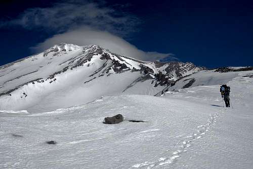
![late ascent]() JD climbing casaval to 10,000' camp at sunset.
JD climbing casaval to 10,000' camp at sunset.
When the alarm went off at 3AM the next morning, I instantly knew that I was too beat from my sled troubles to summit. Dan was having problems with his foot, so I helped Joe and JD pack, lent them any gear they needed, and then drifted back to a blissful sleep. It was just as well, since Joe and JD encountered heavily sugared snow that turned them around before the hourglass. When we dropped into Avalanche Gulch on our descent from camp and I bombed downhill with sled in tow I could, for a fleeting moment, almost convince myself that the trip down had made all my troubles the previous day worthwhile.
Joe and JD were supposed to return later that year in April, while I went climbing in the Yosemite. JD snapped his collarbone in a cycling accident before the trip, so Joe went solo. On the drive up, realizing he'd forgotten his ice axe, he called The Fifth Season and somehow convinced them to leave a rental axe out back when they closed. Arriving at the trailhead, he discovered he'd also forgotten his helmet and that there was no moon. Undeterred, he climbed the route anyway, getting off-course in the dark and topping out on the Whitney Glacier just as the sun came up and prevented him from stumbling into the bergschrund. For the rest of us, the route would have to wait.
![camp at 10,000 feet]() Leaving camp for first window to check in on Joe and JD.
Leaving camp for first window to check in on Joe and JD.A Perfect Summit
A year later, in sharp contrast to the 04/05 and 05/06 seasons, the primary reason not to attempt Casaval was always the snowpack. Shasta was bare, with high winds transporting most of the meager snowfall off the mountain. We kept waiting, kept expecting a big dump to come in and make the conditions right, and as the months passed by the route almost seemed to get worse, not better. Finally, by the end of March, as I left my job and started packing for a summer on the road, we accepted that winter was over. There was no big storm coming to save the winter climbing season; it was now or next year.
Learning from our past mistakes, JD and I left early in the afternoon on Tuesday with plans to pick up food in Mount Shasta, get a good sleep overnight at the trailhead, and start hiking well before the day warmed up. We initially had our sights set on Casaval, but given the low-snow conditions decided at the last minute to try the West Face Gully and save Casaval for a time we could do the catwalk.
When we woke at sunrise on Wednesday morning, the upper parts of the mountain were shrouded by heavy cloud cover. It was a blue-bird day in most of Northern California, but the Shasta weather machine was causing the mountain to live in its own microclimate. Fortunately the clouds kept the sun back, and we had good firm pack as we snowshoed up and left of Casaval.
![Great Weather]() JD peers into hidden valley from the ridgeline we wound up on. You wouldn't believe it, but it was sunny and clear in the other direction.
JD peers into hidden valley from the ridgeline we wound up on. You wouldn't believe it, but it was sunny and clear in the other direction.![Point 9487]() Chatting with a skier on the ridgeline above hidden valley.
Chatting with a skier on the ridgeline above hidden valley.
A couple hours' work brought us to the top of a ridgeline where a spectacular view across the valley below made it apparent we were several hundred feet above our destination. I really hadn't done much pre-trip planning and was shocked to learn we were more or less there already.
"Hidden Valley's only nine thousand feet?"
"That's kind of lame, isn't it?"
![hiking to first window]() Hiking up to first window along our spur ridge.
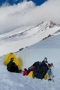
Hiking up to first window along our spur ridge.![camp at first window]() Melting water at camp.
Melting water at camp.
Not only would we lose elevation by dropping into Hidden Valley, we'd get there before noon and spend the rest of the day waiting. Last year we'd all labored under heavy packs, exhausting ourselves by the time we reached 10,000 feet, but today JD and I felt great. Although both in worse shape than last year, we'd been taking weekly hikes up local peaks with 60 pounds of water, and the sport-specific training was doing wonders. Never before had I lifted an overnight winter pack and thought "this feels light!" We both wanted to get as high as possible to prepare for summit day, so we consulted the map and came up with a new plan: camp at first window, follow Casaval beneath the gendarmes to the toe of the last scree field, and then cut to a chute in the prominent diagonal rock band and cross into the West Face Gully.
First window had a few pitiful rock walls for wind protection, but we were lucky to find a depression between two wind drifts that was perfect for enlarging into a tent shelter. The clouds on the upper mountain had now mostly cleared, but the movement of the remaining ones belied a ferocious wind up top. Tendrils of cloud would appear up high, descend over the Red Banks, and then retreat with alarming speed. Done melting water and with nothing left to do, we went to bed at sunset (8pm) for a refreshingly full night's sleep.
![Shasta and Shastina]() Shasta and Shastina.
Shasta and Shastina.
When we woke at 3:30 the night was still, clear and warm. We took our time gearing up and got rolling around 4:20. Normally first window gets hammered by wind, but tonight there wasn't even enough breeze to flap our tent door. The snow was perfect styrofoam, firm but not icy, and there was good visibility to the upper parts of the mountain. If we failed today there would be no excuses - summit opportunities rarely come wrapped in a bow and laid at your feet like this one.
We hit the top of the diagonal rock band in 2 hours, and it provided a good spot to rest, eat and drink. Both our camelbaks were frozen, although I could thaw my uninsulated hose to a trickle by biting on the tube as I walked and warming it with my breath. Our training hikes had accustomed us both to constant movement powered by a steady trickle of energy gel and water; we would have to make sure we deliberately stopped to hydrate until the sun melted our bladders.
![topping out]() JD tops out on the West Face Gully.
JD tops out on the West Face Gully.
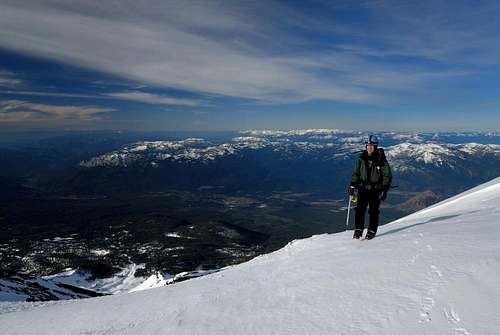
From below, the rock band we crossed seemed to be most of the way up the route, but this proved to be nothing more than a neat visual trick. The remainder of the West Face Gully seemed to take forever. I'd pick a spot uphill to stop for a drink, figuring it was 10 minutes away, only to reach it 25 minutes later. Our pace slackened, a combination of realizing no weather was en route and poor hydration, along with the poor energy intake that inevitably encompasses it. An hour into the gully, the twin peaks marking the top looked no closer. Two hours in, only marginally so. Finally, after close to 3 hours, we topped out and got our first view of the upper mountain. I'd been eager to check out what lay ahead, and in the last 100-200 vertical feet I kicked it up a notch and pushed ahead of JD. I took a few running steps as the slope leveled off and realized "that was stupid, now I feel like crap."
My big concerns were a mild but sudden-onset headache and fairly severe nausea, both classic indicators of AMS. As we took a break at the base of Misery Hill, I gave some serious thought to immediate descent. Last year I'd ignored AMS warning signs on Mt Conness and only our slow progress kept me from winding up in a heap of trouble. At the same time, there was a serious chance I was just suffering from dehydration and overexertion at the top of the gully. In the end, based on the easy and quick descent available, I decided that continuing uphill would not pose a significantly greater risk than staying in place and waiting to see what happened after rehydration.
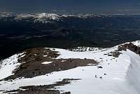
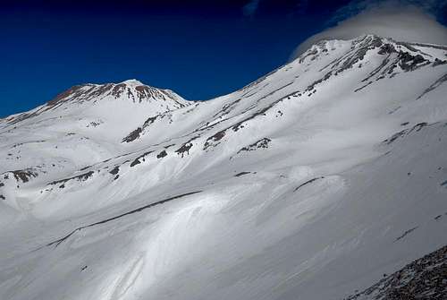
![Misery Hill]() View of Shastina and the Whitney Glacier from Misery Hill.
View of Shastina and the Whitney Glacier from Misery Hill.![Summit Plateau]() Crossing the summit plateau.
Crossing the summit plateau.
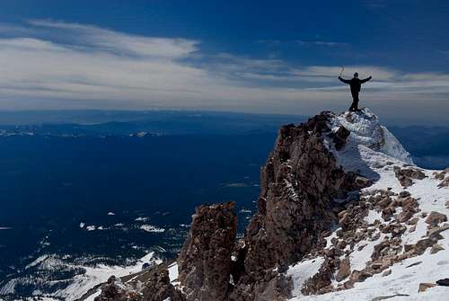
Pressing on proved to be the right decision, and my symptoms eased as I slowly rehydrated and reenergized. By the time we crossed the summit plateau I was feeling great, and we summitted around 11:30AM to 31-degree weather and sunny, windless skies. We snapped some summit pictures, ate some snacks and dried fruit, and chatted with a few other groups that were on their way up. Conditions were so perfect that part of me wished I could park it with a beach chair, a beer, and a grill and spend all day on the summit. Unfortunately, lacking the foresight to bring any of these items up the mountain with us and eager to get down before the afternoon rockfall started in the gully, we had to abandon our perch at the top of northern California and begin making trail back down.
![summit]() The Summit!
The Summit!
I suffered from sun exposure on the way down and had to spend an hour sitting inside the tent drinking water before I felt okay venturing back into sunlight for the trip down to the trailhead. Despite liberal use of sunscreen throughout the trip, my whole face would peel over the next several days and I was already feeling the burn. We hit the trailhead in late afternoon, had some cold beer and leftover pizza, and spent the night cruising I-5 back to the Bay Area.
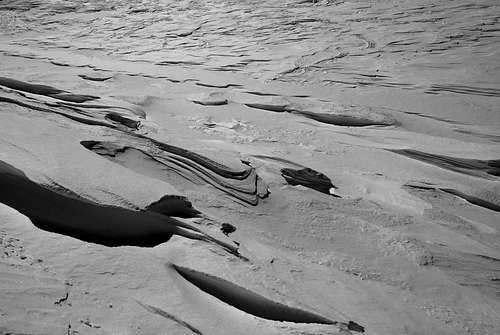
![wind-carved snow]() Wind-carved snow at the base of misery hill.
Wind-carved snow at the base of misery hill.


Comments
Post a Comment