Intro
I recently made a somewhat accidental trip up the Hotlum-Bolam Ridge route on Shasta. I wish I'd tried this route sooner, but I think that like many people the approach rumors and overall lack of information kept me away. The route is on par with popular moderate west face routes like Avy Gulch and West Face Gully, but unfortunately sees far publicity.
The primary point of this trip report is to encourage others to check out Shasta's North side and provide some solid route information. I only have limited experience with this route, and it may change dramatically as it ices up in late season. However, as of my trip date (June 07), snow conditions were probably better here than on the West side.
The lack of beta makes it hard to be sure were were actually on the right path, but other than some confusion over the last 1000' I believe our trip followed the "actual" route. Use the route info here at your own risk and discretion.
The Back Story
On Friday 6/15, JD and I were supposed to climb Hood on the tail end of a cascades mountaineering trip. Waking up for an alpine start, I'd just finished getting my long underwear on when we heard the initial tap-tap-tap of raindrops on the roof of my camper shell, followed by the distinctive smell of fresh rain on the asphalt of the Timberline parking lot. We scrambled and got the rainfly on the camper just as it started pouring. Two hours later there was heavy mist with low visibility, and at daybreak conditions were unchanged. Hood was a loss.
Fortunately the weather dissipated as we headed south across Oregon, and by the time we hit the California border it was warm and sunny, with barely a cloud in the sky. Our trip mostly over, we had two remaining objectives: climb Black Butte, the 2000' tall volcanic cinder cone near Shasta that had always taken a backseat on previous trips, and scout northern approaches for future trips to the Hotlum/Bolam area.
![bolam trailhead]() The Bolam trailhead. Don't go here.
The Bolam trailhead. Don't go here.
Word on the street was that Shasta's northern routes involved high-clearance 4WD roads and terrible bushwacking, and having had more than a few summit bids torched by approach days we figured a recon of the area would stack the odds for future trips.
Guidebooks at The Fifth Season suggested the Bolam Trailhead as a starting point, and our initial observations confirmed everything we'd heard. We followed a burly, poorly-signed dirt road to where it unexpectedly terminated miles from the mountain at 5500'. A mostly-buried sign in a boulder pile indicated that this desolate scrap of desert land was the trailhead, but it definitely wasn't the right place to start a climb from.
We turned around and made tracks for the Northgate trailhead, which proved to be a much better venture. A well-signed, well-maintained road led to a genuine trailhead, complete with toilet, parking, and wilderness registration. JD had started drinking while we were scouting, and now that I was done driving I grabbed a cold one from the fridge as well. It was already 8:30 and the plan was to drink some beer, relax, and sleep in well past daybreak before spending a couple hours checking out the approach.
There were a couple cars in the lot, but the only other people were two guys who'd just come off the mountain with shocking news: Shasta's climbing rangers, with help from a youth corps, had laid a trail above treeline to somewhere around 9500'. There was nothing to scout.
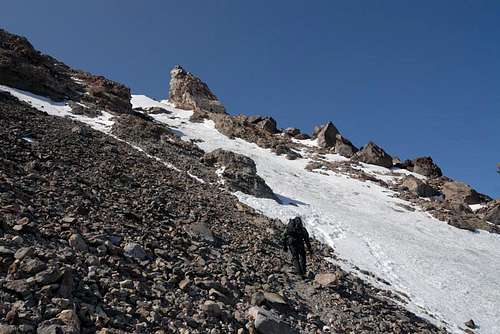
![uphill]() marching up towards the first gully.
marching up towards the first gully.
This placed us in somewhat of a predicament. JD was already on beer #4 and I had two left Koflach boot shells, courtesy of a climbing partner who accidentally packed my right boot on the way back from Rainier the previous week. We were hardly what you would call prepared, and while a two-day trip would have been ideal, we only had food for one. Despite the poor odds, we decided to go balls-out and try the route in a day.
After making dinner and packing we got to sleep around 11PM for a 1:15AM wakeup and 1:50 start. We wore running shoes and carried our plastics up the trail and then talus to around 10,000' at 5AM, where it became obvious we could stay on snow the rest of the way up. The shoe switch took a while, but we were rolling on hardpack with boots and crampons by 5:25.
The guys in the parking lot had warned us about some ice below the two parallel crevasses, and from the saddle at 10,000' we could see a two-man team in the area. They were moving slowly and obviously not happy with the situation; we initially thought about coming up climber's right of the ice, but that would require crossing a short section of the bluest and shiniest stuff up there. In the end, following the two-man team up the middle seemed the way to go.
The area was slick and self-arresting would have been difficult, but it was hardly pure water ice. Our crampons and axes had plenty of bite, and there were tons of dips and features in the surface to make good footholds. We circled around the two parallel crevasses (someone please explain to me why this isn't a glacier???) and proceeded uphill through the snow gully.
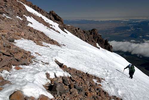
![top of the gully]() Coming off snow at the top of the first gully above the bergschrunds.
Coming off snow at the top of the first gully above the bergschrunds.![second gully]() Up the second gully.
Up the second gully.
We caught the two-man team at the top of the gully; they were roped up with full crevasse rescue gear. The crevasses we'd crossed earlier and their glacier gear gave me brief pause, but I'd never heard of this being an actual glacier route. I was hoping to chat with them, but they turned around just short of the flat spot on top of the gully as they weren't feeling well. Given their pace this was no doubt a wise decision.
From the top of the first gully we followed tracks up a second gully to another rock band. A brief trip across rock brought us to a third gully with somewhat thin and rotten snow cover beneath a prominent rock formation that our parking lot beta identified as the Shark's Tooth. Our pace started slacking a bit as JD suffered from the beer he'd had the previous night, but we were still making good time to the summit and it gave me the rare opportunity to position myself ahead of time for photo opportunities.
![below the shark s tooth]() Gully #3, immediately below the shark's tooth.
Gully #3, immediately below the shark's tooth.![shark s tooth]() JD looks over at the Shark's Tooth as we near the summit saddle.
JD looks over at the Shark's Tooth as we near the summit saddle.
I was feeling strong as we pulled out of the gully and onto the final summit saddle, but the real validation for all the trail humping we'd done in the cascades came when we joined paths with the hordes of Avy Gulchers for the last several hundred feet. We were moving at a normal walking pace, but side-by-side with people resting on their axes every step we were hauling ass. Having been slow before, it was great to feel solid through the summit, especially with our lack of planning.
We summitted around 10:15-10:30, relaxed until 11:30, and then headed back down the mountain. I found myself sorely wanting a victory beer, and decided that next time I climb Shasta I'm brining one with me to the top. The snow was soft but an unfortunate icy crust made glissading a painful proposition and forced us to walk most of the way down; there as a glissade track down to the two crevasses, so some people obviously have better luck than we did.
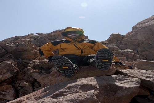
![Two Left Feet]() Hanging out at the summit with two left feet.
Hanging out at the summit with two left feet.Route Info
To get to the Northgate trailhead, take I5 to 97 at Weed, and go NE on 97. The turnoff from 97 is marked by a large green sign that reads "Mt Shasta Wilderness Trailheads" or something similar; from there the road had paper signs directing us to Northgate. The Mt Shasta main page has FS Road #s for the drive. The trailhead had a bathroom, wilderness/climber registration station, and waste bags.
![approach trail]() Approach trail.
Approach trail.
From Northgate, we followed the trail to treeline just above 9000 feet in around 2 hours. The trail began to fade, but we followed either a use trail or naturally occurring switchbacks (it was hard to tell by headlamp) on talus up to a saddle at around 10000 feet. We could have hopped on snow sooner, but the talus slopes weren't bad and we didn't want to plastic up prematurely if more dirt lay ahead. I'd recommend hopping on snow here, as identified in the red line below:
![end of trail]() View up to 10,000' saddle and beyond from near the trail's end.
View up to 10,000' saddle and beyond from near the trail's end.
There were a number of tents setup on snow just below the saddle at what looked like a good campsite. Running meltwater was available nearby, eliminating the need to melt snow, but I've no idea how reliable this is. Several flat gravel tent sites were located climber's right of the approach trail just above 9000'.
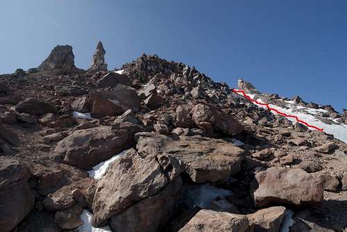
![hotlam-bolam]() View of the hotlam-bolam route from the northgate trailhead. Line shows our ascent route. Red line starts at around 11,000 feet, detours around the two bergschrunds/crevasses, and ascends the first snow gully. Blue line ascends the second gully. Green line ascends the optional third gully below the shark's tooth.
View of the hotlam-bolam route from the northgate trailhead. Line shows our ascent route. Red line starts at around 11,000 feet, detours around the two bergschrunds/crevasses, and ascends the first snow gully. Blue line ascends the second gully. Green line ascends the optional third gully below the shark's tooth.
Once at the saddle, the route goes gradually uphill to climber's right of a thin rock band (not visible in any of my photos). Just past the rock band, cut up and slightly left (this is where the red line starts in the B+W photo above). When we did the route the bottom of the red line was slightly icy, but still very reasonable without protection. There are two permanent crevasses on the route, and you may need to move sideways around them; this is visible in the above photo. Above the second crevasse, you ascend a large snow gully.
![top of first gully]() View uphill from the top of the first gully.
View uphill from the top of the first gully.![descending the second gulley]() Descending the second snow gully.
Descending the second snow gully.
At the top of the first gully, the route flattens out and you enter a second gully, one that extends down climber's right towards the Bolam glacier. Head directly uphill (above picture) until you hit the rock band.
![third gully]() Looking uphill from the top of the second gully.
Looking uphill from the top of the second gully.
When you hit the rock band, you have two choices: head left and follow the ridge to the top (haven't done it, can't provide directions) or traverse right into a third gully and follow the gully up to the Shark's Tooth. The SP route page describes the left variation, but The Fifth Season sells a map that identifies the right variation, throwing the "proper" route somewhat into question. A route image available on shastaavalanche.org seems to identify both. Our parking lot info was to go right, and the snow proved to be fairly thin and rotten; on the way down we chose to descend scree climber's left of the gully. If the snow looks to be solid the gully probably provides a nicer ascent, but later in the season I would opt for the ridge.
![entering 3rd gully]() Entering the third gully.
Entering the third gully.


Comments
Post a Comment