
-
 19973 Hits
-
 83.1% Score
-
 16 Votes
|
|
Mountain/Rock |
|---|---|
|
|
46.56390°N / 11.83630°E |
|
|
Hiking, Trad Climbing, Skiing |
|
|
Summer, Fall, Winter |
|
|
8766 ft / 2672 m |
|
|
Overview
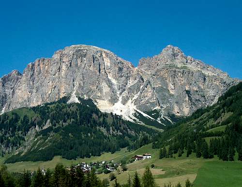 Sass da Ciampac and Sass da Ciampai Sass da Ciampac and Sass da Ciampai |
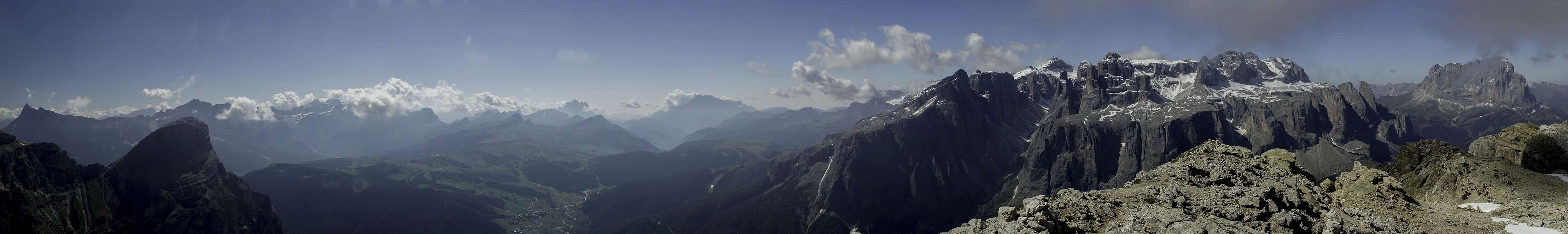
Sass da Ciampac is a prominent mountain in the south of the large Puez Plateau, above which it rises by only a couple of hundred metres. Sass da Ciampac is a three summited mountain, which commands wonderful views of the Sella Group in the south, the Puez-Geisler Group in the north, east and west and the Langkofel Group in the south west. Its direct neighbours are Sasshonger in the east and Cirspitzen / Pizes da Cir to the west.
Its normal route is an easy hike from Grödner Joch / Passo Gardena, which crosses the beautiul Crespeina Saddle, from where the north-west slopes of the mountain can be climbed via a marked trail. To the south, however, the mountain drops for several hundred metres towards Kolfuschg / Colfosco from where a dozen climbing routes of all difficulties lead to the top. The Rock is solid and resembles the better routes in the neighbouring Sella Group. Since the face is pointed southward it offers good opportunities even in winter when ski lifts and cable-cars can take you to the trailheads for the climbs. There are two prominent features, both of which are popular among climbers: on the western pre-summit you find a prominent ramp, which takes you halfway up the mountain and the main summit can be reached by a chimney "Geschweifter Kammin", which is bent in a wide arc.
|


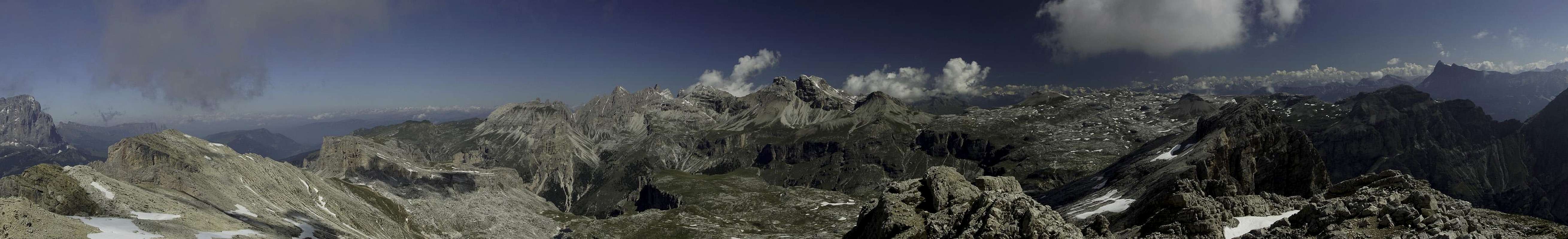
Summit Panoramas
  |
 |
Climbing Routes (a kletterwebbbi suggestion)
There are a number of routes on the S-face of Sass da Ciampac. In general you have to reach the base of the S-face as described in the "Getting There" section. From there it is a scree and rock scramble towards the start of the climbs. The three climbs listed here all start close to the prominent eastern gully where the bent chimney of the S-face route is clearly visible. Via Adang starts somewhat to the east of this gully (barely visible path).- Via Adang: UIAA 5, 6 hours, 450 m height, 11 pitches with a very demanding crux, F. Pospischil, G. Adang, G. Nagler, 1903. Often done, start early to avoid crowds.
- S-face: called "Geschweifter Kamin" (bent chminey), UIAA 4-5, 5 hours, 450 m height. First climbed by E. Gerhard and A. Reither in 1910. Good rock, the most popular route in the past, done rarely now.
- S-face ridge: UIAA 6, 8 hours, a variant to the S-face route above. There is a ridge left (W) of the bent chimney from above which the route separates from the S-face route. Seldom done, first climbed by N. Cattaneo and A. Cacchetti in 1935.
Getting There
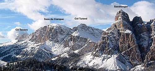 Cir Towers, Sass da Ciampac, Sasshonger
Trailhead for Sass da Ciampac is the Grödner Joch / Passo Gardena for all climbs. The pass can be reached most easily by car.
- From North (Brenner Pass)
- Take the Brenner Motorway A22 southward to Waldbruck / Ponte Gardena
- Leave the motorway and take SS242 into Grödnertal / Val Gardena
- After Wolkenstein / Selva Gardena the road ascends to Grödner Joch / Passo Gardena and Sellajoch / Passo Sella.
- From Belluno:
- Drive along SP1 as far as Ponte nelle Alpi
- Turn onto SS51 to Castello Lavazzo
- There switch to SS51b to Vodo di Cadore
- In Pierosa switch to SS48 to Andraz
- Continue along the SS244 to Corvara
- Switch to SS243 to Grödner Joch / Passo Gardena
- From Venice and Treviso:
- Take motorway A27 to Belluno, exit Pian di Vedoia,
- Turn onto the SS51 to Pierosa
- Switch to SS48 to Andraz
- Here switch to SS244 to Corvara
- Finally take SS243 to Grödner Joch / Passo Gardena
- From Innichen / San Candido and Dobbiaco / Toblach:
- Drive along SS49 as far as San Lorenzo di Sebato
- Continue along SS244 to get to Corvara.
- Finally take SS243 to Grödner Joch / Passo Gardena
- From Brunico:
- Drive along SS242 to get to Corvara
- Take SS243 to Grödner Joch / Passo Gardena
To reach the base of the south face, also start from Grödner Joch / Passo Gardena. Take the scenic marked trail "Kolfuschger Höhenweg", which eventually leads to Kolfuschg / Colfosco. After 30 min you'll reach a large clearing,from where you can scramble up to the south face climbs.
Red Tape - The Natural Park Puez-Geisler
 Evening on Passo Crespeina
The Natural Park has been created in 1977 and contains an area of 10,703ha. Within park boundaries any building activities are prohibited. Flowers, berries, mushrooms, minerals have to be left in their environment. Camping is prohibited and cars have to be parked in the official lots.
For further information on the park, take a look at the official website.
There are no fees or limitations for climbing, however you might have to be prepared for small parking fees.
Accommodation
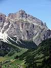
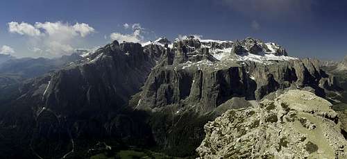 Sella Group from Sas dla Ciampac
Weather Conditions
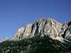
 Sass da Ciampac above Gherdenecia Plateau
Maps & Books
Books
- Climbing
- Alpenvereinsführer Dolomiten: Puez / Peitlerkofel
E.E. Striebitz
Rother Verlag
ISBN: 3 7633 1307 9
- Dolomiten, Genussklettereien III-VI
Anette Köhler, Norber Memmel;
Rother Verlag
ISBN 3-7633-3001-1
- Alpenvereinsführer Dolomiten: Puez / Peitlerkofel
- Hiking and Trecking
- Höhenwege in den Dolomiten
H. Dumler
Bruckmann Verlag
ISBN: 3 7654 3860 X
- Dolomiten 1
F. Hauleitner
Rother Verlag
ISBN: 3 7633 4248 6
- Höhenwege in den Dolomiten
Maps
- Sellagruppe / Gruppo di Sella
Kompass Map WK 59
1:50000
ISBN: 3 8549 1066 5
- Val Gardena & Alpe di Siusi
Tabacco Map 05
1:25000
In Memory of Stefan "kletterwebbi" Weber
 A note from the SP staff
Stefan Weber, the member we all used to know from his climbing pseudonym kletterwebbi, died on May 28th 2004 in southern France at the age of 37.
Stefan joined SP early on in 2002 and contributed a number of excellent pages and routes to this site. He was an accomplished climber excelling in difficult alpine and technical routes. The Dolomites, especially the area around Gröden / Val Gardena were special to him, as it was his old ancestral home.
kletterwebbi was always willing to share his knowledge and experience with other climbers, mainly here on SP, but also on other sites. He contributed his IT expertise as webmaster of his local section of the German Alpine Club, where he also engaged in leading trips for fellow members. Besides his climbing and mountaineering activities he was a musician, a composer of contemporary music. Stefan will be greatly missed by us all.
This page will be kept in honor of kletterwebbi, one of SP's most talented, knowledgeable members, and without a doubt, one of our greatest fellow mountaineers.
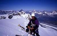
The picture was taken on the summit ridge of Lyskamm.