
-
 9172 Hits
-
 80.49% Score
-
 12 Votes
|
|
Mountain/Rock |
|---|---|
|
|
46.72220°N / 12.84330°E |
|
|
7500 ft / 2286 m |
|
|
Overview
Geographical Classification: Eastern Alps > Gailtal Alps > Lienz Dolomites > Lumkofel
Lumkofel is an unimpressive summit in the Gailtal Alps, located south of the Lienz Dolomites. It is very close to the latter range and since it is located in the triangle between the towns of Lienz (north, Kötschach-Mauthen (east) and Sillian (west) it can be counted to the Lienz Dolomites. When seen from the north the mountain seems to show a vertical limestone face with several (about 6) bowling alleys coming down. So the Dolomite character definitely is there. From all other sides it appears to be very easy – but don’t be fooled!
The easiest ascent runs along a dent in the south “face”, a 45° meadow, which leads to a saddle in the eastern summit ridge. This trail is marked sparsely (see route) but nevertheless easy to fins. Another – beautiful – trail climbs to the east ridge from its eastern end – but trail-less over 60° meadows. And the western route uses the 50° west face over steep rocky ledges, covered with scree and gravel. None of the routes offer possibilities for security and especially the western route has to be climbed with great care.
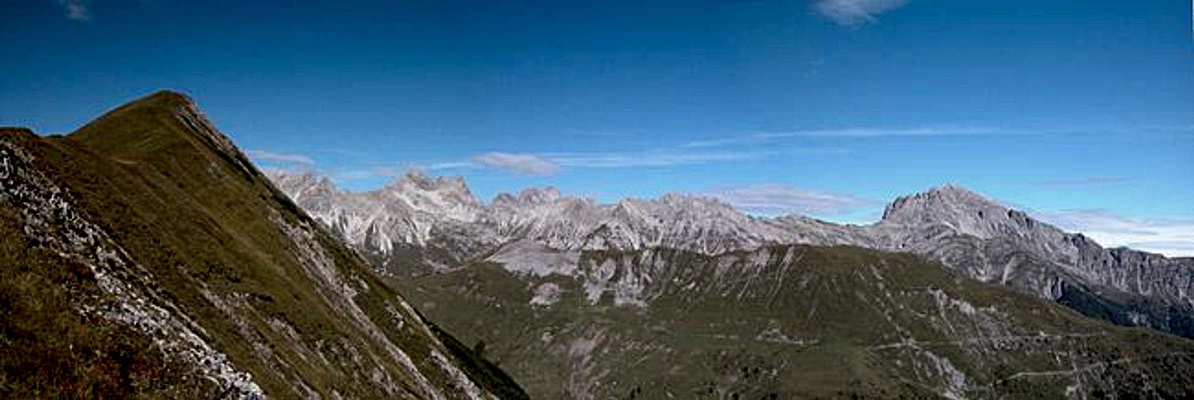
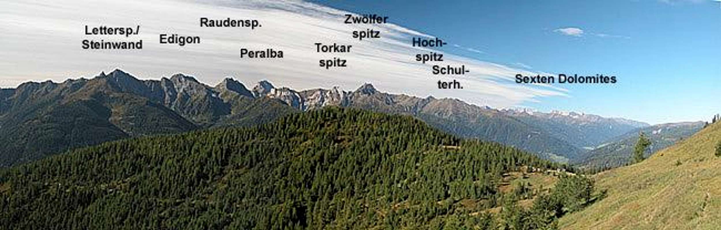
But why climb a 2286m summit, when there are many higher summits close by? Lumkofel’s location between the Lienz Dolomites and the Carnic Alps Main Ridge makes it the perfect lookout peak. The distance to the Lienz Dolomites is large enough so that you can see the whole Sexten Dolomites eastern side from afar, but still have close-up views of the main summits of the eastern Lienz Dolomites as well. The Carnic Main Ridge with its highest mountains, Kellerwand (2774m) and Hohe Warte (2780m) is near by and on a clear day you can see them all.
As a recommendation I would suggest to climb the mountain from the western side, do the short but panoramic east ridge traverse and descend to Grifitzbühel on the eastern side of the mountain. The descent will be trail-less along meadows which is why it is suited better for descent than ascent. Unfortunately we did it the other way around, which made the hike one of the most exhausting we did in 20 days of vacation.
 |  |  |  |
Summit views

Due to its solitary location between Lienz Dolomites and Carnic Alps Lumkofel offers some great viwes towards these mountains as well as the Sexten Dolomites.
 |  |  |  |
Getting There
The best starting point for an ascent of Lumkofel is the hamlet of Assing (north of Liesing). The trailhead is located to the south of the Lienz Dolomites in the Lesachtal Valley. The valley is rather remote but getting there is far from complicated (though lengthy).
From the West (Brenner Motorway A22)
Leave the Brenner Motorway near Brixen / Bressanone and follow SS49 to the east through Pustertal / Val Pusteria. To the east of Innichen / San Candido you cross the Austro-Italian border and follow the road (now B100) to Tassenbach. Turn right (south-east) here onto B111, which you follow to Liesing. In the village turn left at an ornamental fountain in the village square. The hamlets of Pallas and Assing are marked by signposts. Parking space is rare in Assing but 500m to the south of the hamlet there are some spots to the side of the road where you can park your car.
From the North
There are two possible roads:
- From Kitzbühel over B108 through the Felbertauern Tunnel to Lienz, then southeast to Oberdrauburg and Kötschach-Mauthen (B110), where you turn on to B111 west into Lesachtal.
- From Salzburg along motorway A10 to Spittal. Turn west on B100 to Oberdrauburg, there south to Kötschach-Mauthen were you turn east on B111.
From the South (Udine)
Take Motorway A23 to the exit Camia Tolmezzo. Follow SS52 north to Tolmezzo where you turn onto SS52 bis. This leads to Plöckenpass, where it crosses the Austro-Italian border. In Austria the road turns into B100 and at Kötschach-Mauthen you have to turn east on B111 into Lesachtal Valley.
 |  |  |  |
Red Tape
I'm not aware of any red tape. The area is used for extensive grazing by cattle and sheep. So close any gates and don't mess with the fences, many of which are electrical.
 |  |  |  |
When To Climb
Lumkofel can be climbed all year round. The west face is probably out of the question in winter but the meadow ascents from the south and east are possible with skis or snow-shoes.
 |  |  |  |
Accommodation
In most of the villages of the area there is a small campground, which in most cases is associated with an inn or hotel. If you are looking for hotel rooms or apartments follow one of the links below
- Lesachtal official site
- Lienz City official site
- Kötschach/Mauthen official site
- Lesachtal lodging (tiscover.at)
- Kötschach Mauthen lodging (tiscover.at)
- Lienz Dolomites lodging (tiscover.at)
- Hochpustertal lodging (tiscover.at)
Weather Conditions
In general the weather in south-eastern Austria (Carinthia and East Tyrol) is much better than in the northern and western parts of the country. Europe mostly is covered by western winds and the clouds from the Atlantic have to climb over the Alpine Main Ridge before they reach the region. So much of the humidity has already left the air. For up to date weather information follow one the links below.
For Webcams try one of the below:
 |  |  |  |
Maps 'n' Books
Maps
I have been using a map by Kompass Verlag, which is very good for the hiking trails though it does not show ALL the relevant summits of the area.
- Lienzer Dolomiten / Lesachtal
1:50000
Kompass Map WK47
Kompass Verlag
ISBN: 3-85491-053-3
Books
You’ll probably not be able to find anything on the Lienz Dolomites in a language other than German. The books I used are (both describe the ascents of Lumkofel ):
- Hiking and Trekking
Osttirol Süd
W. Mair
Rother Verlag
ISBN: 3-7633-4132-3 - German
ISBN: 3-7633-4307-5 - Italian
Good descriptions with maps covering: Defregger Berge, Villgrater Berge, Carnic Alps, Lienz Dolomites
- Gailtal – Lesachtal – Karnischer Höhenweg
Kompass Wanderbuch 982
Kompass Verlag
ISBN: 3-85491-500-4
Good Descriptions with maps and elevation profiles covering: Carnic Alps, Southern Lienz Dolomites (two routes to Lumkofel), Gailtal Alps