
|
|
Mountain/Rock |
|---|---|
|
|
35.95160°N / 51.98390°E |
|
|
11876 ft / 3620 m |
|
|
Overview
Also known as: Namak KosarMy GPS/Altimeter showed that this mountain was 11930 ft (3636 m) high. The 3620 m figure is per a series of maps in "Atlas of Shemiran" by "Gitashenasi".
Click for Introduction to Central Alborz Mountains.
Click for a map of Namak Koohsar & Lar Lake area. You may also want to see a map of the Dokhaharan area to the north of Namak Koohsar.
If you are looking for a view like this:
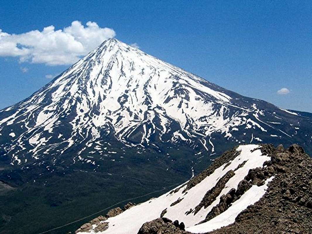
you must get yourself to the top of this mountain.
Sitting across the Deli Chai River Valley from the 5671 m Mt. Damavand, Namak Koohsar is ideally located to provide one of the best views of Mt. Damavand. The base of the monstrously large cone of Mt. Damavand covers an area 25-30 Km in diameter. This makes Damavand appear as a single peak that rises above a plain while in fact it sits in the middle of the Alborz Mountains and is surrounded by other peaks (that are much lower than it: upper 3000 to lower 4000 m). With a distance of only 10.5 Km, Namak Koohsar is probably the closest peak to Damavand.
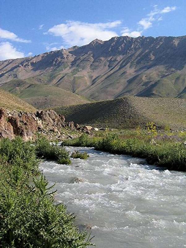
Namak Koohsar consists of a 5 Km long ridgeline that runs northwest to southeast and is entirely above 3400 m. On the crest of this ridgeline, you will find many rocky high points that tower above the lower slopes. The official summit is one of these high points somewhere near the middle. To the south of Namak Koohsar there is a 3075 m peak known as Asal Asal. The north slopes of Asal Asal create a sheer wall that is a few hundred meters tall and is well visible from the slopes of Namak Koohsar (I have never heard or read anything about this wall). To the south of Asal Asal, you will find the Lar River Valley. A dam constructed on the Lar River creates a very long lake that meanders among the mountains at the bottom of the valley. Its turquoise waters enhance the beauty of the area. Lar Lake is the largest of the three mountain reservoirs that provide drinking water for the 10 million plus mega-city of Tehran.
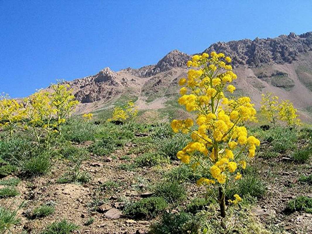
The lower slopes of Namak Koohsar are covered with beautiful alpine tundra including a shrub that is roughly one meter tall and is covered with yellow flowers (what is the name of this shrub?, see picture below). Other nearby slopes are dotted with growths of wild poppies.
Namak Koohsar can be climbed via its southern slopes above the Lar Lake. This area falls into the Lar River Protected Zone (Entry requires a permit, see “Red Tape” below). The zone protects a pristine alpine valley that starts with the Lar Dam to the east and stretches west up the slopes of the 4000 m plus peaks that form its headwaters near Mt. Kholeno the Great. From the beautiful summit of Namak Koohsar, the most impressive view will obviously be that of the giant cone of Mt. Damavand to the east. To the north, you will see the 4338 m Dokhaharan Peak and the other 4000 m plus peaks around it. To the west, there will be an endless sea of high peaks that culminate in the 4387 m Kholeno the Great in the western horizon. To the southeast, you will see the 55 Km long Dobrar/Ghareh Dagh ridgeline (highest point 4072 m) stretching as afar as the eye can see creating an impenetrable wall. The views of Lar Lake will be spectacular.
Namak Koohsar is rarely ever climbed. This was a peak that I picked off the map and decided to climb without ever hearing anything about it. Fortunately, I was able to make it to its summit on my own. Walking into the unknown and exploring the beauty of the mountains is what I feel mountaineering is all about.
 |  |  |  |  |
Getting There
From eastern Tehran drive 65 Km up the Haraz (Tehran-Amol) Rd, past the Ab-Ali Ski Area and Emamzadeh Hashem Pass (2700 m) to the town of Poloor (2250 m) at the base of Mt. Damavand. Take a left turn onto a small side road that goes to Lar Dam. After less than 10 Km, you will reach the Lar Protected Zone. If you have a permit, you can drive up a dirt road (passable by most/any car) a few more kilometers until the Road crosses the Deli Chai River (2550 m). Here you will find a rough four wheel drive road that follows the river. You can park at the beginning of this road and start your hike.
 |  |  |  |  |
Red Tape
Entering Lar Protected Area requires a permit. My permit was obtained by my tour company and I neglected to ask them where they got it from. Any guide/tour company should be able to obtain this for you. |  |  |  |  |
When To Climb
June to October. I prefer mid June when there is still snow on the top and the grass on the lower slopes is green and the flowers are in bloom.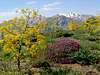 |  |  |  |  |
Camping
Anywhere. |  |  |