
|
|
Mountain/Rock |
|---|---|
|
|
36.28936°N / 51.03258°E |
|
|
Mountaineering |
|
|
Summer |
|
|
13041 ft / 3975 m |
|
|
Overview
Click for Introduction to Central Alborz Mountains.Click to see the Map of the Takhte Soleyman Massif.
Siah Leez Peak 3975 m:
Siah Leez is one of the southern peaks of the Takhte Soleyman Massif. To the east, Siah Leez is connected to the 3958 m Varzakool Peak. These two peaks are separated from the 4198 m Zarrin Kooh Peak via a 3820 m saddle to the southeast.
 South Face South Face |  West Face West Face |  South Face South Face |
The southern and western slopes of Siah Leez go down into a branch of the Shah Rood (Taleghan) Valley while its northern slopes drop into a branch of the Chalus Valley. Siah Leez and its neighbors form a barrier to moisture from the Caspian Sea. These peaks sit on the crest of a ridgeline that forms the transition from the forested northern slopes (below 2300 m) of the Alborz Mountains to the non-forested southern slopes.
 South Face South Face | 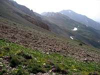 West Face West Face |
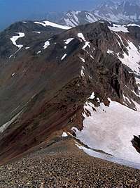
The summit of Siah Leez is quite long and narrow. A round-top rocky high point gives rise to the highest point of the mountain. You will find a fairly large plateau that sits at an elevation of 3880 m between Siah Leez and the Varzakool Peak to the east.
 Summit Summit | 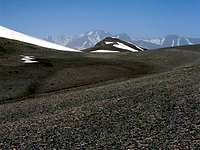 Flat Area Flat Area |  Summit Summit |
Siah Leez is usually climbed starting at the 2350 m village of Narian which sits in a branch of the Taleghan Valley to the south. Most of the route for Siah Leez is the same as that for Zarrin Kooh Peak. While from the village of Narian, the higher Zarrin Kooh Peak can not be seen, Siah Leez is well visible.
Views from the summit of Siah Leez:
 Alam Kooh Alam Kooh |  Alaneh Sar Alaneh Sar |  Meeshchalak Meeshchalak |
 Varzakool Varzakool |  Zarrin Kooh Zarrin Kooh |  Abidar Abidar |
Varzakool Peak 3958 m:
Varzakool sits between Zarrin Kooh and Siah Leez Peaks. Its southeastern slopes create a wall but its western face is quite gentle and gives rise to a broad plateau-like saddle that separates it from Siah Leez.
 Southeastern Face Southeastern Face |  Southeastern Wall Southeastern Wall | 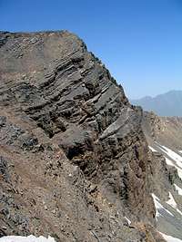 Southeastern Wall Southeastern Wall | 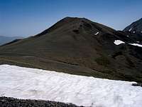 West Face & Broad Saddle West Face & Broad Saddle |
Route Information:
Click here to see the Route page for Zarrin Kooh Peak.
Follow the route from Narian Village (2350 m) to the mentioned 3820 m Saddle. At the saddle Zarrin Kooh will be to your southeast and Varzakool Peak to the northwest. You can see the impressive rocky east face of Varzakool. Head northwest and bypass Varzakool Peak on its easy southern slopes until you reach the plateau between Varzakool and Siah Leez. You can then follow any path to the top of Siah Leez.
Distance from the 3820 m saddle is 1.1 Km
Distance from Narian Village is 12.1 Km
 Siah Leez & Varzakool
Getting There
Directions to Narian VillageFrom the western parts of Tehran, Drive the Tehran-Qazvin Freeway 40 Km west to the town of Karaj, continue roughly another 60 Km to a village called Abyek. A little on the west side of Abyek, take the exit to “Ziyaran-Shahrak”. Drive this road 40 Km north to reach Shahrak (or Shahrake Taleghan). This town sits at the bottom of the Taleghan (Shah Rood) River Valley. Continue the road past Shahrak heading east 15 Km to reach the village of Jowestan. Here, right goes to the village of Gateh Deh and left to Narian. Take the left road and drive 8 Km to a split in the road. Left goes to the village of Parachan and right to Narian. Take the right road and cross the bridge then drive a few kilometers up a saddle and then down to reach the village of Narian.