
|
|
Mountain/Rock |
|---|---|
|
|
39.05860°N / 105.2228°W |
|
|
Teller |
|
|
Hiking |
|
|
Spring, Summer, Fall, Winter |
|
|
9459 ft / 2883 m |
|
|
Overview
 Pikes Peak from Signal Butte
Signal Butte is a conical little peak northwest of the town of Divide. It is relatively hidden from view from Highway 24. It offers fantastic views of Pikes Peak, Teller County, the Tenmile/Mosquito Ranges, and the Sawatch Range.
This mountain is very accessible, and offers an easy hike-up route to its rocky summit. It is a great day trip for Teller County and Colorado Springs residents. The butte also has a great scramble route for the more adventurous.
Signal Butte is in one of the main areas that was hit by the Hayman Fire of 2002. This link from Teller County actually shows an inferno coming off of Signal Butte, as well as general info about the fire. As you hike in this area, the extent of the damage of the fire will be apparent, even though years later. Burned stumps, trees, and new undergrowth will be everywhere.
Getting There
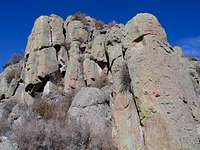 The south side of Signal Butte
The Hayman Fire of 2002
If you climb Signal Butte, you will see the ravages of this famous forest fire.The Hayman Fire was the largest in Colorado's history. It consumed 137,000 acres of forest and residential areas. 133 homes and one commercial building were lost to the blaze. IT caused $39 million in damage, and may take $150 million to restore what it damaged.
Given the above statistics, it should surprise and infuriate you that this fire was caused by a US Forest Service Worker! Terry Bond, the aforementioned Forest Service Worker, and a 20 year veteran of the service, admitted that she started the fire by burning a letter from her estranged husband in the forest. Bear in mind that this was in the middle of the worst drought in recent memory. She is currently serving a 12 year prison sentence.
US Forest Service Study
Wilderness Society Study
From Wildfire Magazine
More info
Space Image of the Fire
Red Tape
The only red tape involves several "off limits" areas where conservation is currently ongoing. They are clearly marked, and do not interfere with the main trail.When To Climb
One could climb Signal Butte year-round. Access may be restricted by vehicle in the winter.Camping
There are several formal and informal campsites in the area, especially along the roads to get to the trailhead. No fees.Mountain Conditions
NOAA Weather Link.You can contact the Pike National Forest Rangers at 719-636-1602 for current trailhead conditions and Pike National Forest conditions.
This part of the front range typically gets less snow than the rest of Colorado, but most of the route will be covered in snow from December to March.