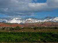
Signal Peak on a hot summer day
It is right there in front of everybody who lives in St. George or who zooms down I-15 on their way to Salt Lake or Las Vegas, a neat mountain range that is a different world from the heat of St. George. However, most St. George residents have no clue that there is this neat area just up behind them and so it isn't visited all that much by the locals.
The reason I was interested in it was because Signal Peak is the highest point in Washington County and I was on a quest to get to the top of every county highpoint in the
state of Utah. Signal Peak would be #26, leaving me just three to finish the state. My son Brad joined me on the trip down to southern Utah and along the way we picked up the highpoints of Iron and Kane county and did the tourist thing at Cedar Breaks National Monument, a treasure land of multicolored sandstones that nature has crafted into beautiful art.
After reading Dennis Poulin's
fine trip report,I decided that that was the way I wanted to access the peak was by going up via the Oak Grove campground as well. So my son and I had a nice dinner in Cedar City and headed to Leeds off of I-15 where we drove the 9 miles of dirt road up to the Oak Grove C.G. where we spent the night camping out. Strangely, we were the only ones in the campground that night and had the place all to our selves. Well, almost all to our selves because we were seranaded all night long by a zillion crickets. Nature sometimes punishes you with mosquitos or if all out of mosquitos, crickets. Those things can be really annoying but I digress.
![The Oak Grove trailhead and...]()
Early the next morning, we started up the trail from the campground past the restroom and the signage and information board. We continued on and found the junction that led up the hill was no longer marked by a sign as indicated in Dennis's report and had it not been for a small cairn placed at the junction, it would have been easy to miss the turnoff. Thanks to the small cairn, we were able to find the right upward path. From that point on, the trail goes up, and up, and up. After a bit, the vegetation (brush) starts closing in on the trail and there are spots where you can't see your feet. Still, if you pay attention, you will not lose the trail and I had a few preset GPS coordinates that I could check from time to time. I could see how you could lose the trail but by backtracking a couple times, the right path was always found.
![Sign at intersetion of Oak...]()
It is a long haul up to the ridge but we were blessed that the heat of the day (100 degrees in St. George) was tempered by a breeze that kept us fairly cool. Once the sun hit the slope, I put on my protective hat and recommended my son put on some sunscreen since he is pretty fair skinned.
We had left the campsite at about 8a.m. and found ourselves atop the ridge at noon. It is a 3500 feet climb from the campground to the ridge, most of it on a fairly steep trail but I found that my son needed some rest stops since he hadn't been able to get out and do any hikes at all due to his job and recently getting married. He never complained but I knew that I better set a pace that wouldn't wipe him out on the descent.
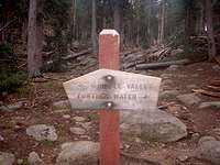
The ridge allowed us some nice views over toward Zion National Park but we didn't linger for long as we preferred the shade on the other side. We followed the trail down and when we came to a flat clearing that had a fire ring in it, we lost the trail. So, we went cross country for awhile and found our way back down to near the sign that indicates the direction to Further Water.
![Heading down Further Water...]()
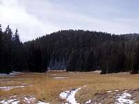
The trail from there went uphill a bit and to the west and soon we found ourselves going across the very nice meadow of Deer Flat. On the other side, it was again back uphill for awhile until reaching another little saddle after which we dropped back downhill to the beginning of Further Water Meadow. There was a little bit of water at the point where the trail drops into the meadow and that was the only water we saw on the whole hike. A pleasant hike across a much bigger meadow brought us to the woods again and from there I knew that we'd go up the trail a bit and then strike out cross country towards the summit of Signal Peak.
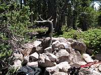
![Summit cairn]()
After checking the GPS and the map, we finally reached the point where a cairn indicated that we had found the "lofty" summit of Signal Peak.Actuall, it was pretty much surrounded by trees but did have a nice view down towards the St. George area. A horseshoe and two registers were found next to the cairn and we determined that the extra register came from where the county highpointers had placed their register at another spot near some trees that was about 50 yards away where a cairn was still present. One register, a white plastic one was leaking and most of the papers inside were wet or moist and the other register (the county highpointer one), a glass one, was in good shape and a small spiral notebook was in good shape as well and so we signed into that one. It was now one o'clock, it had taken us the better part of an hour to get from the ridgeline to the highpoint and so after taking some pics and eating some lunch, we finally made our move to retrace our steps.
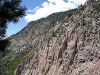
![From high on the Oak Grove...]()
From the ridgeline on down, we took it slow and did our best to enjoy the views, the trail and each other as we had a lot of things to talk about.
Finally, we made it down to the camp site where we packed up everything and put them away and left a hike that really made us work for our reward.
My GPS read 4400 feet of elevation gain, most of that is done on the way up to the ridgeline but both my son and I would agree it was a great adventure. We saw no one else the entire day but did finally see someone else who had camped at the campground. Hiking distance was probably ten miles but we did some extra little cross country excursions on the way up to the peak. We probably took eight hours to hike up and down and one hour of summit time to make for a nine hour day. From there, we drove up to Cedar City, got a motel room and went and visited Bryce Canyon the next day. Two days later, I was climbing American Forks Twins with my good friend Dennis Poulin. What a great trip.
[img:122608:alignleft:small:]


Comments
Post a Comment