Signal Peak, we there yet?
Signal Peak
Elevation 10,365
May 28, 2006
Our goal of bagging all of Utah’s County highpoints started in May 2006. On the way to Washington County’s Signal Peak, we stopped at a Geocaching Spring Event in Farmington.
After signing in and purchasing two 2006 Utah Geocoins, we set down and looked at a geocoin collection. Soon it looked like a feeding frenzy of ‘icon grabbers’ writing down the coin and travel bug tracking numbers, so they could be logged when we got home to a computer. Little did I know, this would be the start of a very bad habit.
ScoutMaster, looking to be the #1 Travel Bug mover in Utah, and seeking a top number in the geocaching community, was writing down numbers and stuffing the bugs in is backpack for the next adventure for them.
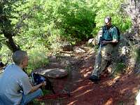
The geocaching events are fun because you can put faces to the handles you see on the web site and caching logs. (My handle is Mtnman1830, Hardy’s is Shphilby, and Rick’s is Rdavis1239) We also eat. Us ‘cachers’ tend to build up an appetite, so food is a must. After lunch, they had an auction. This time, they were auctioning off some Mtn-man coins (no relation). I started walking up closer to the front and make the first bid at ten dollars. Immediately after, a bid of $15 was made. I couldn’t go any higher, and as I got to the front, lo and behold it was Hardy that had won. When a PEZ geocoin went up on bid, I waited until the bidding went to five dollars, then bid. Hardy bid ten dollars knowing he could knock me out of the bidding. (The puts). So I was snafooied out of two geocoins, but at least another geocacher whom I was e-mailing gave me a micro generic geocoin. Thanks DMRodCo!!!
After all the commotion, we just chilled and met some of the other cachers that were there. There was a news station there, covering this sport, or shall I say ADDICTION, and doing a story on it.
We finally left the meeting at 2:00pm and started hitting caches on the way to Cedar City. While we were hitting the caches that had coins or travel bugs, we ran into another geocacher named Clodbuster2. We visited for a while, gave him some tracking numbers we had, and continued on our way. We picked up some more coins and a Cach-U-Nut and finally arrived at camp at 11:00pm. I took out my camera, and when I turned it on, BATTERIES EXHAUSTED flashed across the screen. Of all the luck. Since it doesn’t take regular batteries, I was S.O.L. After a freeze-dried meal, we hit the sack.
Unfortunately, my tent wasn’t a freestanding, and the ground wasn’t solid enough for the stakes to take hold. Needless to say, the tent fell down around 1:00am, but we tried to sleep through it until 3:00 when Rick and I went out and fixed it. It ended up being rewarding when I looked up and saw the jewel-ridden sky, but after being up for 32 hours, I needed a good rest, but it just wasn’t going to happen.
When our alarms went off at 5:30, none of us were ready. Finally at 6:00 we dragged ourselves out of bed and ate bagels and fruit and broke camp. We managed to be at the trailhead at 6:38am.
Not far from the trailhead, we ran into a man that said in a thick Russian accent “Are you looking for what I am looking for?” Nearing a large boulder, we could see that he was holding a map and a Garmin eTrex Legend GPS. “Here it is.” He said as he looked over the edge. I walked through the brush and handed it to him.
We sat and chatted for a bit about the Puzzle Caches and the like. This cacher we had run into is the one and only Mockba.We told him that we were going to Signal Peak. He said that we passed the turnoff. He showed us where it was and then continued up with us.
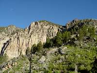
The switchbacks were steep and nearly obscured by scrub brush. In a few months, it would be difficult to find one’s way on this path. The trail continued up to the ridge of the ominous mountains that are in view the entire hike. Atop the white cliffs, the view from the top is amazing. A vast panorama across the desert is rewarding. In the distance, Zion National Park is seen. I can hardly wait to see what the view is like from the top. But sooner than that, what is it like on the other side of the ridge? It will not have views over St. George and Zions- This reminds me of the Cub Scout song “The bear went over the mountain to see what he could see…”
![Scenery]()
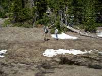
Nearly on the ridge, -Mockba is long gone by now- There are large boulders, some are as big as a house. We scrambled up to capture the view and take some photos. The scene was truly amazing. When we crested the ridge, it was full of snow. Seeing Mockba’s trail, we needed to transverse the backside of the mountain to the bottom of the valley. The snow was up past our knees in places, but it was fairly compact and we were able to walk on top of most of it. Our snowshoes are sitting in the car back home. After nearly a month of temperatures between 80 and 90, we didn’t think we would really need them.
We climbed another knoll and back down again to what well be in a month or so, a lush meadow. This is the first of two we will travel through on the way. This area is great, a small mountain vista surrounded by solitude and trees, nearly untouched except by those eager enough to conquer the switchbacks.
At the end of the second meadow, we are nearly there. Just ½ mile as the crow flies. Entirely worn out by both no sleep, and post-holing through deep snow, the reward is nearly there. A rock cairn, with a geocache, marks the top of the mountain. The trees are too thick to give a rewarding view but nonetheless, mission accomplished.
We were back at the trailhead at 4:08 making the time on the trail 9 ½ hours. From the trailhead to the summit is the longest four-mile hike I have ever been on. Hellacious switchbacks for the first 2/3 then deep snow the rest of the way. I can’t wait for the next one!
Comments
No comments posted yet.