The name of the mountain is a reference to the colour of its limestone and dolomite rocks, so it could be translated as Hoary / Pale Grey Peak. (As for names of natural geographic features, the Slovak language uses lower case for the initial letter of the type of feature.)
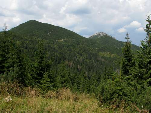
Ostrá and Sivý vrch seen from SE
Ostrá or Ostré/Ostra - Sharp
Babky/Babki - Grandmas
Mních/Mnich - Monk
Sokol/Sokół - Falcon
vrch (pronounced vrkh)/wierch or štít (shtit)/szczyt = peak
sedlo/przełęcz (psheh-wentsch) = pass/saddle
dolina/dolina = valley
skala/skała = rock
pliesko/stawek (stahvek) = little tarn
potok/potok = brook
chata/schronisko = hut
poľana/polana = clearing/glade
malá/mała = little (feminine)
Overview
Dark, forested Sivý Vrch Group in front (Sivý vrch left, Babky right of centre); snow-sprinkled Roháče Group in background - photo by visentin
Sivý vrch (elevation 1805m, prominence 235m) with its three ridges forms a tiny, but distinct mountain group – the westernmost in the Western Tatras. In the west the group is divided from the Choč Mountains by the valley of Borová voda brook, Vyšné Hutianske Saddle at 950m, Javorina Saddle at 1185m and the Suchá (Sielnická) Valley. In the east the Jalovecká and Bobrovecká valleys along with Pálenica Saddle at 1570m and Pribišská brook separate the group of Sivý vrch from the granitoid group of Roháče.
West ridge of Sivý vrch seen from Ostrá
The northeast and west ridges of Sivý vrch are parts of the Tatras’ main ridge. The northeast ridge, which is is around 2km long and does not boast anything special, connects the summit to sedlo Pálenica. In contrast, the west ridge (nearly 4km long, ending at Vyšné Hutianske sedlo) is adorned with an array of fascinating, bizarrely-shaped dolomite rocks named Radové skaly.
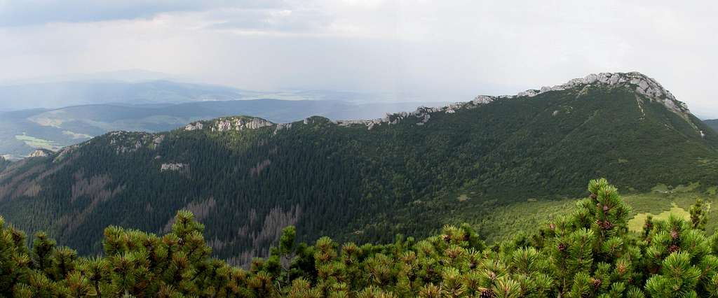
The largest and longest (over 6km) ridge within the Sivý Vrch Group is the lateral ridge that runs south from Sivý vrch summit. In fact, it is this mighty spur that allows us to think of the group of Sivý vrch as a distinct region of the Western Tatras. Apart from Sivý vrch the ridge has two conspicuous summits – Ostrá (1764m, 125m of prominence), just south of Sivý vrch, and Babky (1566m, 75m of prominence) at the south end of the ridge – both accessible via the waymarked trail. Besides, Malá kopa (1637m, 52m ) sitting in the middle of the ridge just south of Predúvratie Saddle and Malá Ostrá (1703m, 23m) between Sivý vrch and Ostrá may be worth mentioning. The latter two summits are covered by thickets of dwarf pine.
South ridge from Sivý vrch: Ostrá on the right, Malá Ostrá (nearer, left of Ostrá), Malá Kopa (far, just left of centre) and Mních peeking out further left
The southeastern branches of the south ridge have broad and gentle tops, which drop dramatically into the Jalovecká Valley thus forming the outstanding cliffs of Mnich (1460m) and Sokol (1316m), which lie within a strict nature reserve (no waymarked trail). On the summit of Mnich remnants of an Iron Age hillfort have been discovered.
As for the analogue maps, there are many options readily available. My favourite is this plastic map by WiT. It has a scale of 1:25,000, is durable and cheap. It can be bought online or in Zakopane and many other Polish towns.
Getting There & Trails
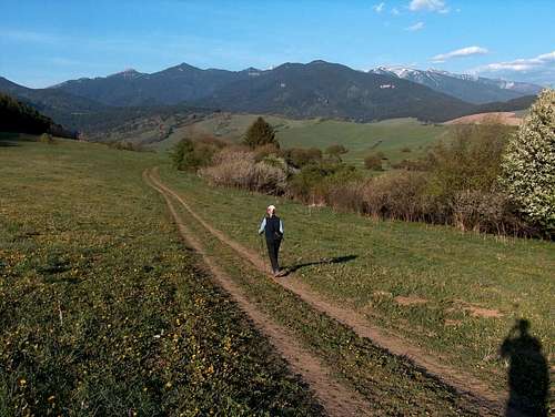
Sivý vrch from Zuberec
NE ridge
Undoubtedly most hikers visiting the area and eager to summit something aim for Sivý vrch. Ostrá is too close to it to be thought of as a destination in itself. The only other option is then Babky - it is usually done as a circuit via Predúvratie Saddle and the Pod Náružím Hut.
The key bases are the towns of Liptovský Mikuláš to the south and Zuberec to the north of the peak. Liptovský Mikuláš has excellent road and rail connections. Zuberec is easily accessible by road, also if you are staying in or near the Polish resort town of Zakopane. Zuberec lies at the very foot of Sivý vrch and offers access to its summit within four hours’ walk – via either the west ridge or the northeast ridge.If you start from Liptovský Mikuláš, it is a good idea to take a bus to the village of Jalovec, approx. 7km away, or to drive 2.5km further to the hamlet of Bobrovecká Vápenica. From the bus terminus in Jalovec you have to walk up the main street for nearly half a kilometre to the trailhead. The yellow marks will cross the stream, then run towards Bobrovecká Vápenica. There you switch marks for the blue ones and go on north up to the trail junction called rázcestie pod Babkami at 1290m. There you can pick either the green marks making a steep, arduous ascent to the summit of Babky (276 vertical metres) or continue along the blue trail traversing the east slopes of the ridge connecting Sivý vrch and Babky, towards a mountain hut called Chata pod Náružím, also known as Chata Červenec. Just before the hut the trail passes a superb, reliable spring. Past the hut the trail goes a bit more steeply up to join the green marks at sedlo Predúvratie at 1585m, on the Sivý vrch–Babky ridge. From Predúvratie it is still about 2.5km to the summit of Sivý vrch. You can make this stretch of the route a little shorter and less tiring if you traverse the east side of Ostrá following an unmarked path instead of climbing this summit. (Both paths run through dwarf pine bushes; surprisingly, the unmarked path is - that is to say it was when I was there in 2018 - better maintained than the marked trail, which fell short of bushwhacking in places.) But the view it gives of Sivý vrch may be worth the effort. Talking of the views, many places on the Sivý vrch–Babky ridge offer picturesque views of the Roháče Group, especially of Pachoľa (2167m) and Baníkov (2178m).
Roháče Group seen from below Predúvratie Saddle
The trailhead for the west ridge of Sivý vrch, which boasts cliffs and weird rock formations, is at Vyšné Hutianske sedlo near the bus stop (several buses per day from Zuberec) named Huty Javorinský potok on the 584 road, about 5km south of Zuberec. The lowest section of the trail, which traverses the northern slopes of the ridge, can get pretty muddy. After an hour's ascent you reach the crest at Biela skala (White Rock, 1378m). Above an elevation of 1600m sit Radové skaly - the most picturesque rock spires, turrets, keeps and the likes, among which a well-trodden path winds its way. Two steeper steps go at YDS class 3 and are chain-assisted. The highest stretch has poor marking, well below Tatra standard, so if you are not extra careful you can walk off the designated route easily, especially while going downhill. It seems like at least one piece of the waymarked trail has been redirected in recent years, but the old, fading marking is still visible, which may cause more confusion.
The table below shows route statistics for select hikes to the summit of Sivý vrch.
Route
Trailhead
Distance
Net Elevation Gain
Time (Way Up Only)
Round Trip Total Elevation Gain
Marks
West ridge
Vyšné Hutianske saddle
nearly 5km
875m
2hr 45min
890m
red
South ridge
Jalovec bus terminus
about 11km
over 1100
about 4hr
over 1400m
yellow, then blue, then green
South ridge
Bobrovecká Vápenica
nearly 9km
about 1040
about 3hr 30min
over 1350m
blue, then green
Northern route (via Pálenica saddle)
Zuberec church (Main Street)
9km
1040m
3hr 30min
nearly 1150m
yellow, then red
Spring near the hut
Predúvratie Saddle
Paths on E side of Ostrá
S face of Sivý vrch
This table shows route statistics for the Chata pod Náružím-Predúvratie-Babky loop.
Start at
Distance
Total Elevation Gain
Time
Marks
Bobrovecká Vápenica
over 12km
about 950m (there, loop and back)
about 4hr 30min
blue, then green, then blue
Chata pod Náružím
over 6km
over 400m (loop)
about 2hr
blue, then green, then blue
Babky from NE
View of Pachoľa and Baníkov
Summit of Babky
From Babky to Ostrá
Red Tape
Hiking
You must keep to waymarked trails, except that traversing the east side of Ostrá via the unmarked path seems to be accepted practice. Camping is off-limits. After dark you are supposed to leave the national park (unless you are staying in a mountain hut). The area lies within the Slovak part of the Tatra National Park, within which trails above mountain huts as well as above the lower reaches of valleys are closed for hikers from 1 November to 15 June. Quite exceptionally, this regulation does not seem to apply to the trail running along the south ridge of Sivý vrch up to the very summit.
Rock climbing is forbidden. Skiing is allowed in the area lying south of Priehyba Saddle (the saddle between Sivý vrch and Malá Ostrá) from 21 December to 15 April – on condition that you are a member of a skiing or climbing club/association, such as UIAA or Alpenverein.
In Slovakia - unlike in Poland - those who do not carry commercial insurance have to pay for any rescue services rendered by Mountain Rescue Service (HZS). In an emergency call 18 300
Most of the area is covered by dense needleleaf woodland inhabited by quite a few brown bears (Ursus arctos arctos), which can be run into when least expected. More about the bears and whether they can make trouble can be found here. Make sure you follow at least the basic safety techniques.
Accommodation
Chata pod Náružím
Chata Zverovka
Hut on the east side of the south ridge at 1420m: Chata pod Náružím aka Chata Červenec run by a local hiking club - to make sure the hut is open on the day you arrive (it is not normally open on weekdays in the off-season), you'd better contact the owner beforehand. The hut serves drinks but does not serve any food! (However, it has a kitchen where you can cook your own food.) There is a roofed shelter near the hut and two springs.
There is a good choice of guesthouses and hotels both north (see e.g. in Zuberec or in/near Zakopane, Poland) and south of the mountains. On the outskirts of the town of Liptovský Hrádok is Borová Sihoť – my favourite campsite
Children refers to the set of objects that logically fall under a given object. For example, the
Aconcagua mountain page is a child of the 'Aconcagua Group' and the 'Seven Summits.' The
Aconcagua mountain itself has many routes, photos, and trip reports as children.
Parents refers to a larger category under which an object falls. For example, theAconcagua mountain page has the 'Aconcagua Group' and the 'Seven Summits' asparents and is a parent itself to many routes, photos, and Trip Reports.

 West ridge of Sivý vrch seen from Ostrá
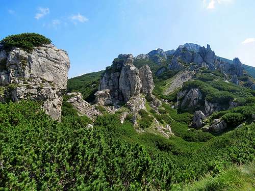 Radové skaly - photo by Konrad Sus
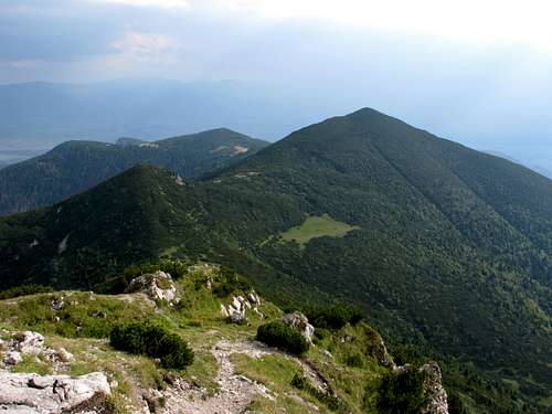 South ridge from Sivý vrch: Ostrá on the right, Malá Ostrá (nearer, left of Ostrá), Malá Kopa (far, just left of centre) and Mních peeking out further left
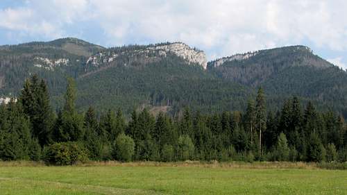 Babky, Sokol and Mnich
 Sivý vrch from Zuberec
 NE ridge
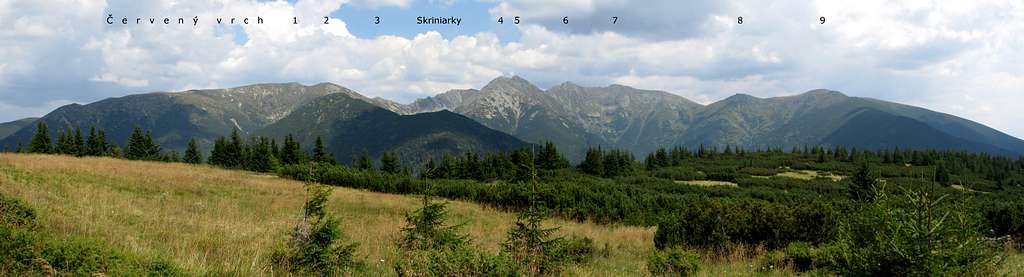
 Photo by Gorzi

 Chata pod Náružím
 Chata Zverovka


