

-
 14277 Hits
-
 84.82% Score
-
 19 Votes
|
|
Mountain/Rock |
|---|---|
|
|
35.49430°N / 111.8418°W |
|
|
8215 ft / 2504 m |
|
|
Overview
Slate Mountain, between Flagstaff and the Grand Canyon in the Coconino National Forest, is often overlooked relative to other mountains in the area. Rightfully so, as Slate Mountain is not a particularly impressive mountain and provides no great difficulty for hikers. However, Slate Mountain Trail #128 does provide relatively easy access to great views of the region, including views of Humphrey’s Peak and Kendrick Peak from the north, Red Mountain and the Grand Canyon from the south, and numerous less prominent geographic features of the Coconino Plateau. It is a worthwhile hike if you are in the region and short on the time or energy required for higher peaks in the area.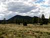 | 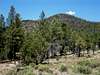 |
Geology
Slate Mountain is one of 600 volcanic features in the San Francisco volcanic field that covers 1800 square miles of northern Arizona. Volcanic activity is often located at the boundaries of tectonic plates, but in the San Francisco volcanic field it appears to be due to a hotspot underneath the North American plate.Although it is not apparent to the hiker, Slate Mountain is primarily a laccolith, a solid igneous intrusion between sedimentary strata. In other words, Slate Mountain is mostly a solid mass of rhyolite that extends 5000 feet under the surface, with partially overlying sedimentary layers that it pushed aside on the way to the surface. The name Slate Mountain comes from one of these layers.
Potassium-argon dating indicates that the volcanic events that created Slate Mountain occurred between 1.5 and 1.9 million years ago (mya), making it younger than Bill Williams Mountain (2.5-5.1 mya), Sitgreaves Mountain (1.9-2.8 mya) and Kendrick Peak (1.4-2.7 mya), but older than Mount Elden (< 0.7 mya) and the stratovolcano consisting of Humphreys Peak and surrounding summits (0.4-1.0 mya). The most recent volcanic activity occurred roughly 900 years ago at nearby Sunset Crater, and another eruption in the region is likely to occur in the next several thousand years.
A tour of volcano geology is easy to accomplish in the region with cinder cones and lava flows at Sunset Crater National Monument and Strawberry Crater Wilderness, lava domes such as Mount Elden or Sugarloaf, a stratovolcano (Humphrey’s Peak) and a mile long lava tube.
Getting There
From Humphrey Street in downtown Flagstaff, turn left on US 180 and head 26.1 miles to the northwest until signed Forest Road 191. Take a left on FR 191 and proceed 2 miles to the signed trailhead and parking area on the right side of the road.The road is passable to low-clearance vehicles in all but the worst conditions and is not maintained in winter.
The Twenty Highest Flagstaff Area Summits
| State Rank | Peak | Elevation | 7.5 minute Quadrangle | ||
| 1 | Humphreys Peak | 12,633 | Humphreys Peak |  | |
| 2 | Agassiz Peak | 12,356 | Humphreys Peak |  | |
| 3 | Fremont Peak | 11,969 | Humphreys Peak |  | |
| 4 | Doyle Peak | 11,460 | Humphreys Peak |  | |
| 12 | Kendrick Peak | 10,418 | Kendrick Peak |  | |
| 59 | Sitgreaves Mountain | 9,389 | Sitgreaves Mountain |  | |
| 68 | Elden Mountain | 9,299 | Flagstaff East |  | |
| 70 | Sugarloaf | 9,283 | Sunset Crater West |  | |
| 74 | Bill Williams Mountain | 9,256 | Williams South |  | |
| 89 | UN 9170 | 9,170 | Kendrick Peak |  | |
| 102 | UN 9065 | 9,065 | White Horse Hills |  | |
| UN 9004 | 9,004 | Parks |  | ||
| UN 8993 | 8,993 | Wing Mountain |  | ||
| O’Leary Peak | 8,938 | O’Leary Peak |  | ||
| Saddle Mountain | 8,880 | White Horse Hills |  | ||
| UN 8843 | 8,842 | White Horse Hills |  | ||
| UN 8842 | 8,843 | Sunset Crater West |  | ||
| Fern Mountain | 8,772 | Humphreys Peak |  | ||
| UN 8747 | 8,747 | Humphreys Peak |  | ||
| Wing Mountain | 8,578 | Wing Mountain |  |
Clicking on the small picture by a peak will take you to a picture of that peak.
Clicking on an underlined peak will take you to that peak's page on SummitPost.
An elevation in red is interpolated.
Red Tape
No permits/fees are required to park or hike at Slate Mountain.When To Climb
April to November is the typical climbing season on Slate Mountain although it can be climbed year round. Forest Road 191 is not cleared of snow during the winter months.Camping
At-large camping sites are plentiful in the surrounding Coconino National Forest. The closest established campgrounds in the Peaks Ranger District are located east of the San Francisco Peaks at the Locket Meadow and Bonita campgrounds.Additional campgrounds for large groups or horse-packers are also available in the region.
Mountain Conditions

For further information contact the Peaks Ranger Station at (928) 526-0866. The ranger station is located at 5075 N. Highway 89, Flagstaff, Arizona 86004.