
-
 41368 Hits
-
 81.63% Score
-
 16 Votes
|
|
Mountain/Rock |
|---|---|
|
|
35.40810°N / 111.85°W |
|
|
10418 ft / 3175 m |
|
|
Overview

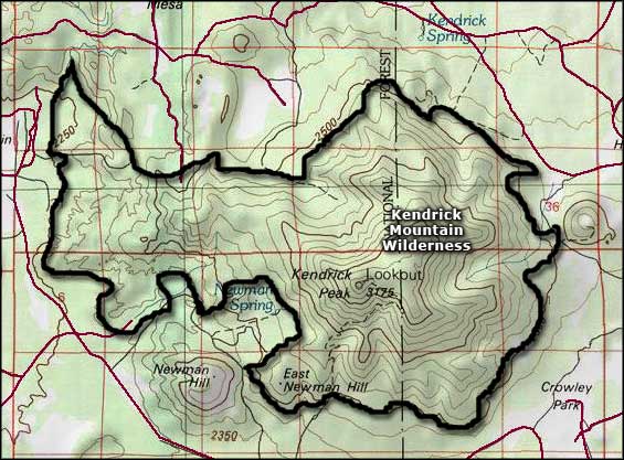
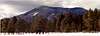
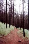
Kendrick is Arizona's 12th highest summit. It is a large lava dome and sits on the same fault that Sitgreaves Mountain and Bill Williams Mountain lay on. There are 3 trails that lead to the top. The Kendrick trail is 4 miles to the top. The trails are easy. There was a fire on the mountain in the summer of 2000, which charred much of the mountain. From the top you can see the Grand Canyon. The view of Humphreys Peak is also impressive.
Kendrick Peak is surrounded by the Kendrick Mountain Wilderness area which encompasses 6510 acres.
 |  |  |  |  |
Getting There
From Interstate 40 west of Flagstaff, take exit 185 at Bellemont. Drive west along the north service road 171. Turn right and follow road 171 north eleven miles to a junction with road 171A. Turn right and drive north one mile to the end of the road at a trail head parking area. You can also take US 180, going towards the Grand Canyon Turn on forest service road 245 then at the end take a Right on to 171. You can go about four miles to the Kendrick trail or keep going until you reach the Pumpkin Trail.When To Climb
Summer after the snow has melted.Camping
Camping is allowed anywhere around the mountain. People often take backpacking trips up the Kendrick trail and down the Pumpkin trail. Camp at the parking lot and hike over the mountain the next day back to their car.Mountain Conditions
noneLava River Cave
Lava River Cave is a lava tube worth checking out if you have time. It is about 3/4 of a mile long. It really has nothing to do with Kendrick Peak, but it's in the area. It is only a few miles away.To get there take US 180 north to the Grand Canyon. Turn left on fr 245. Take that road all the way to the end where it T's into fs 171. . From there you will see a sign that says 'Left Lava River Cave, Right Kendrick Trail." Turn left and then about 1 mile later turn left again. The road dead ends and you park there. Then hike about 1/4 of a mile to the cave enterence. To enter the cave hike down about 50 feet. From the top you will see the cave enterence.

 |  |  |
Arizona's 20-20 Challenge
Yes Arizona has it's own little challenge just like other states do like the Colorado/California 14ers, Idaho 12ers, or even doing all the State High points.Arizona's Challenge is the 20 highest and the 20 deepest. What this means is the 20 highest mountains that are not on protected areas and has a trail to the summit and the 20 deepest canyons with the same criteria.
The mountains all have an elevation gain of at least 1,000 feet. The listing of the Peaks and Canyons are yet to come.
For more information go to Arizona's 20-20 Challenge
| Mountain | Canyon |
| Humphryes Peak | Grand Canyon |
| Mount Baldy | Tuckup Canyon |
| Escudilla Peak | Paria Canyon |
| Kendrick Peak | Oak Creek Canyon |
| Webb Peak | Jumpup Canyon |
| Heliograph Peak | KP Canyon |
| Charicahua Peak | Salome Canyon |
| Flys Peak | kanab Canyon |
| Showshed Peak | Secret Canyon |
| Miller Peak | Jacks Canyon |
| Wrightson Peak | Bear Wallow Canyon |
| Monte Vista Peak | W. Clear Canyon |
| Blue Peak | Fossil Springs |
| Mount Elden | Havasu Canyon |
| Bill Williams Mountain | Long Canyon |
| Carr Peak | Hack Canyon |
| Mount Lemmon | West Fork |
| Clark Peak | Sycamore Canyon |
| Sentinal Peak | Wet Beaver Canyon |
| O'Leary Peak | Agua Fria Canyon |
Steven Cross - Apr 16, 2002 9:58 am - Hasn't voted
Untitled CommentWhich trail did you use? I dont remember a cabin, but then again its been a long time since I hiked it. I've only done the Kendrick trail.
callthedoctor - Apr 17, 2002 3:57 am - Voted 10/10
Untitled CommentThe old cabin is at the junction of the Kendrick trail and the Bull Basin trail...really hard to miss...I have some photos...I could try and scan if your interested...
Actually, I think it used to be considered the Fire Lookout until 1964 (or 1967?) when the current tower was constructed....
There is a plague/certificate type thing in the current tower registering it has a historical landmark.
The Pumpkin trail hits the current tower on the western end of the mountain and doesn't pass this cabin unless you continue downhill to the aforementioned junction...
Inside the small (guess 8'x10')cabin were some very old spring beds (one was a bunk), a fire log, a empty med kit, and many hiker signatures/engravings....
Later
Larry/Flagstaff, Az.
callthedoctor - Apr 16, 2002 3:41 am - Voted 10/10
Untitled CommentHistoric cabin build in 1912 sits at the saddle...another 1/2 mile of switchbacks to the current fire lookout tower. From tower,great 360 degree views onward of 50-60 miles on clear days...
Steven Cross - Apr 16, 2002 9:58 am - Hasn't voted
Untitled CommentWhich trail did you use? I dont remember a cabin, but then again its been a long time since I hiked it. I've only done the Kendrick trail.
callthedoctor - Apr 17, 2002 3:57 am - Voted 10/10
Untitled CommentThe old cabin is at the junction of the Kendrick trail and the Bull Basin trail...really hard to miss...I have some photos...I could try and scan if your interested...
Actually, I think it used to be considered the Fire Lookout until 1964 (or 1967?) when the current tower was constructed....
There is a plague/certificate type thing in the current tower registering it has a historical landmark.
The Pumpkin trail hits the current tower on the western end of the mountain and doesn't pass this cabin unless you continue downhill to the aforementioned junction...
Inside the small (guess 8'x10')cabin were some very old spring beds (one was a bunk), a fire log, a empty med kit, and many hiker signatures/engravings....
Later
Larry/Flagstaff, Az.
Alex Wood - Nov 7, 2011 12:10 pm - Voted 10/10
Getting There SectionFound one little mistake (which could prove fatal for some folks) ..."You can also take US 180, going towards the Grand Canyon Turn on forest service road 245 then at the end take a left on to 171"...that should be a right, not a left. Nice page other than that!
Steven Cross - Nov 9, 2011 10:37 pm - Hasn't voted
Re: Getting There Sectionoops, will be changing that! Thanks for pointing that out