
|
|
Route |
|---|---|
|
|
44.16220°N / 109.6151°W |
|
|
Ice Climbing |
|
|
Most of a day |
|
|
WI4 |
|
|
4 |
|
|
Overview
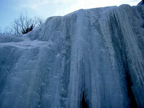
The approach to Smooth Emerald is a haul, make no mistake. But this is said to be the longest moderate (WI4 or less) route in the South Fork area at 250m.We climbed about four roped pitches :
P1: 35m ? WI4 - short but steep/vertical curtain, followed by easier slab and a tree / bush anchor.
From here hike up drainage. There are some short bulges, and a 15' section of WI2 which we soloed on the way up (look for tree anchor to rappel on descent).
P2: 50m ? WI3 - a bulge to a ledge, then 40m of 80 degree ice. Harder than it looks :) Belay from tree anchor or ice screws.
Hike up drainage on snow and bulges.
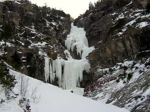
P3: 65m ? WI4 (crux pitch) - steep / vertical curtain, then a ledge, then more steep ice. Belay from ice screws.
With 70m ropes our belay was situated about halfway up the formation shown in the picture.
P4: 65m ? WI3-ish - moderate rolling ice. Belay from screws (ideal) or tree (see below). This will be above the rock band shown in the picture above.
The guidebook says at this point the drainage splits, and holds several 5-15m bulges and curtains. It was getting late, so we started our descent instead of continuing.
The rappel from the top of the fourth pitch (ours, not the book's) should ideally be done from a v-thread. The tree belay is positioned such that ropes can get stuck easily, snagging on rock or twigs. How do I know this ? Let's just say our descent involved headlamps ...
But wait - once you rappel back to Deer Creek, you are not yet done with the climbing. You still have to get back up to the trail - climb back up that section you rappelled down (may involve 5.4 rock, easy mixed, thin ice, etc) and scramble back up, then make the long haul back to the car. Did I mention headlamps ?
Enjoy a cold one in town - you've earned it :)
Getting There
First off, I forgot my GPS when I climbed this route, so I don't have coordinates :(With that in mind, take the South Fork Road 4.3 miles past the fork with Hunter Creek Road to the Deer Creek trailhead (just before the Deer Creek bridge) and park.
Hike up the Deer Creek trail, switchback after switchback. Be aware of bighorn sheep, and patchy ice hidden under shallow snow. You will enter the Deer Creek drainage.
Pass two south-facing pillars (View to a Thrill / Dressed to Kill [70m, WI5]) on the right, then a frozen waterfall below the trail (Slogger [65m, WI4]) where you head down, and then back up.
There are some steep switchbacks up after that, above The Ghosts (80m, WI4, on the south side of the drainage), into the trees, then to a 100m scree slope nicknamed "The Clearing". Pass Transient Alterations (110m, WI3-5) on the right and Fredericks of Hollywood (100m, WI3+) on the left (viewed across Deer Creek), several hundred meters after The Clearing.
About 0.25 mile past Transient Alterations you will arrive at the Bitches Brew (200m, WI5+) drainage, which goes up and to the right. But for Smooth Emerald you want to scramble down towards Deer Creek.
About 30-35m or so above Deer Creek there should be some rap slings (this is about 5.4 if it's dry - it may also be iced up). Once at the creek head up 150m to the base of the climb.
Snow coverage in February when I was there was pretty spotty near the trailhead at 6500', but at higher elevations we had to break trail in places. It probably took us about 1 hour 45 minutes to get to the Bitches Brew drainage, and another half hour or so to drop down to Deer Creek and then get to a point where we could rope up for Smooth Emerald's first WI4 pitch.
Definitely bring headlamps and be prepared to use them. This is an all-day adventure !