
|
|
Mountain/Rock |
|---|---|
|
|
44.53734°N / 107.5157°W |
|
|
Bighorn |
|
|
Hiking |
|
|
Spring, Summer, Fall |
|
|
9220 ft / 2810 m |
|
|
Overview
Snowshoe Mountain towers over the headwaters of Shell Creek. This mountain is one of the last outposts of the southwestern Bighorn Range. It marks the transition from forested alpine terrain into the rugged high desert of Shell Canyon. The most accessible route is pleasant moderately steep hike. The summit view ranges from the peaks of the Cloud Peak Wilderness (east) to the cliffs of Shell Canyon.
Getting There
The primary access is from Wyoming Highway 14 which goes from the town of Dayton up and over the western Bighorn Range to the town of Shell. This well-maintained highway is open year-round and is a beautiful drive in and of itself.
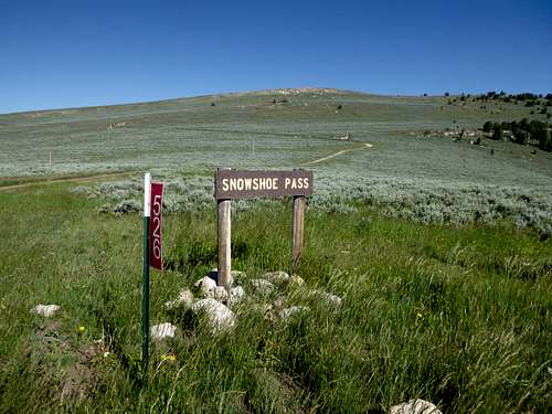
From Highway 14 turn east on Forrest Road 17. Zero your odometer here and continue up FSR 17 passing Shell Campground and a Ranger Station. When you come to the Ranger Creek campground stay right and continue up FSR as you gain elevation up some switch backs. The road is generally well maintained but a bit rough in spots. A pickup, SUV or Subaru should have no trouble. After 5.2 miles (from the highway) you will come to a small spur road labeled 526. Take a right on 526 and drive for 0.2 miles and park along side the road. A faint trail departs from here.
Route
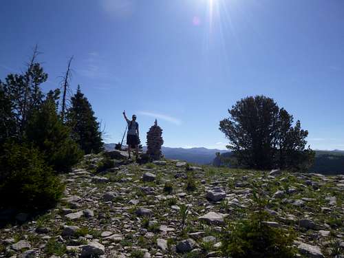
There is no real defined route to the summit. From the parking spot a small trail ascends generally north toward the summit. When the trail sputters out followed the small openings between the sagebrush to the top. What appears to be the high point from the road is the south (lower) summit. The actual summit to the north is marked by two large cairns and can’t be missed. Elevation gain from the parking spot to the summit is approximately 465ft.
Red Tape
No permit is required.
When to Climb
The main factor limiting access is snow blocking the access road. Generally FSR 17 should be passable from May thru October.
Camping
Primitive dispersed camping is widely available. Shell Creek and Ranger Creek campgrounds are very nice facilities and are in close proximity as well.
External Links
Add External Links text here.