
|
|
Area/Range |
|---|---|
|
|
41.36100°N / 106.318°W |
|
|
Hiking, Mountaineering, Skiing |
|
|
Spring, Summer, Fall, Winter |
|
|
Overview
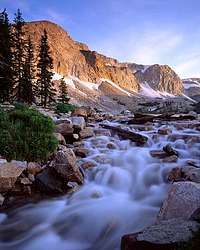
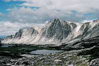
The Snowy Range is the jewel of southern Wyoming. Jagged peaks, crystal blue alpine lakes, alpine meadows and wildflowers, and beautiful subalpine fir forests await your exploration! This area is at a high elevation (approximately 9,000-12,000') and snow can occur any month during the year. The Snowy Range is transected by Wyoming Hwy 130 between Laramie and Saratoga. This is a National Forest Scenic Byway and there are many campgrounds, picnic areas, and hiking trails along its course. There is also the small Snowy Range Ski Resort as well as areas to cross-country ski and snowshoe in the wintertime. However, you cannot drive all the way across Hwy 130 during the wintertime.
The Libby Creek Trail, Medicine Bow Peak Trail, and the Lakes Trail are three popular trails in the area. Click here for more trail info on trails on the Laramie and Brush Creek/Hayden Ranger Districts.
Medicine Bow Peak is the highest peak in the Snowy Range at 12,013'. It is also the highpoint of Albany and Carbon Counties. Nearby Browns Peak and Sugarloaf Mountain can also be climbed.
Getting There

From Laramie: I-80 to the Snowy Range Exit (Exit 311) and head west on Snowy Range Road/Hwy 130 & 230 for about 1 mile. Turn a sharp right onto Highway 130 towards Centennial.
From Saratoga: Take Hwy 130 south then west to the Snowy Range.
Click here for more info on how to order a map of the Medicine Bow National Forest
Red Tape
No permits are needed to hike in the Snowy Range. Follow Leave No Trace ethics.
There is a modest fee if you park in the day use areas and trailheads. Interagency Annual, senior, and access passes are also accepted. Click here for more information on the day use passes.
All off-road travel by motorized vehicles is prohibited in this area.
Dogs must be kept on a leash while in the day use, trailhead, or campground areas.
External Links
Medicine Bow-Routt National Forests
Weather Forecast for the Snowy Range
Info on the 1955 plane crash at Medicine Bow Peak
Camping

Campgrounds
These three campgrounds are closest to the highest part of the Snowy Range. All are over 10,000 in elevation.
Brooklyn Lake
19 sites, 30' maximum vehicle length
Sugarloaf
16 sites, 25' maximum vehicle length
Silver Lake
16 sites, 32' maximum vehicle length
These three campgrounds are a little further away from the highest peaks but they're lower in elevation (~8,000 feet) and typically open a little longer in the season.
Libby Creek
38 sites, 30' maximum vehicle length
Ryan Park
48 sites, 30' maximum vehicle length
South Brush Creek
20 sites, 32' maximum vehicle length
To make reservations at any of these campgrounds (except Silver Lake and South Brush Creek, which are first-come, first-served), visit www.recreation.gov or call toll-free 1-877-444-6777
Click here for more camping info
Dispersed Camping
Dispersed camping is also allowed in some areas of the Snowy Range. Contact the Laramie Ranger District Office for more info: (307) 745-2300. Remember to bring plenty of water and pack out what you pack in.
Rent a Forest Service Cabin or Lookout Tower!
Little Brooklyn Lake Guard Station
Spruce Mountain Lookout Tower

Little Brooklyn Lake Guard Station in winter

Little Brooklyn Lake Guard Station in summer

Spruce Mountain Lookout Tower
Visitor Centers
Forest Service visitor centers are located on Highway 130 near Centennial on the east side and Brush Creek on the west side and are open in the summertime. Stop in to get maps, books, and more info!
For more information, please contact
USDA Forest Service
Medicine Bow-Routt National Forests,
Thunder Basin National Grassland
2468 Jackson Street
Laramie, WY 82070
(307) 745-2300
www.fs.fed.us/r2/mbr