
-
 8653 Hits
-
 77.3% Score
-
 8 Votes
|
|
Mountain/Rock |
|---|---|
|
|
41.33776°N / 106.32974°W |
|
|
Carbon |
|
|
Mixed |
|
|
11440 ft / 3487 m |
|
|
Overview
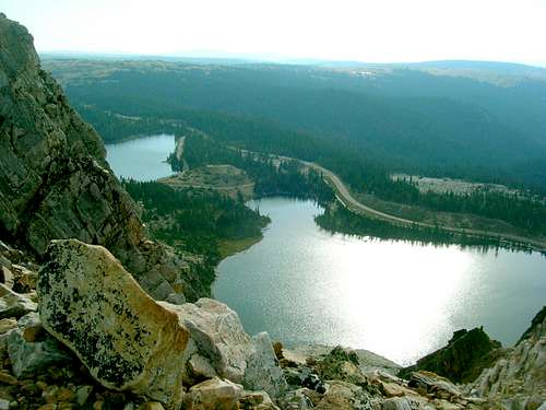 View of Lake Marie below Schoolhouse Rock
Schoolhouse Rock, at 11,440 feet, is the southernmost rock face of the massive Snowy Range in Wyoming's Medicine Bow Mountains. It is often overlooked because of the popularity of nearby higher summits - The Diamond, Old Main, and Medicine Bow Peak. At close to 900 feet above Lake Marie below, the quartzite face offers some good technical climbing opportunities. And for those whose time, skill or physical limitations will not allow for such an ascent, the trail from Lake Marie offers a scenic route to take in the beauty from the top. Many hikers stop at Schoolhouse Rock on their way to the summit of Medicine Bow Peak. For others, Schoolhouse Rock is their sole destination. Whatever your choice, the views along the way are more than worth your efforts. Many hikers exploring this area of the Snowy Range, have searched for the wreckage of a plane crash that happened near Lake Marie in the 1950's. If parts of that plane are in Lake Marie, they are well-hidden. One of the engines from that plane is off-trail northwest of the lake less than a mile.
Getting There
 Trail Break
 Barber Lake Road
The Lake Marie trailhead (west) is about a one hour drive west of Laramie, on Highway 130. The lakes, campgrounds, and trailheads are on the north side of the highway. There should be no problem recognizing the Snowy Range, since it totally dominates the northern skyline. If you are traveling east from Saratoga on Highway 130, your drive should take you just under an hour. The Lake Marie trailhead is at the southwest corner of the lake, near the parking lot.
Route for Hiking
 Schoolhouse Rock Hiking Route
The most direct hiking route to the summit of Schoolhouse Rock, begins at the Lake Marie Trailhead for Trail 295, the Medicine Bow Peak Trail. The altitude at the trailhead is about 10,500 feet, so your ascent will take you 940 feet up over approximately 1.2 miles to reach the summit. If you are going on to Medicine Bow Peak from there, it is another 3.3 miles to that summit.
Red Tape
There are no permits required to hike or climb, but if you are camping, please be aware of current restrictions on open fires, gathering firewood, or discharging firearms. The ranger stations listed below can give you all the latest updates and information on restrictions and special advisories.
When To Climb
 Photo by Belexes
 Schoolhouse Rock West Side
The best time of the year to climb is usually July through September. The risks of lightning strikes is greatest during summer afternoons, so your best bet is to hike or climb early. Winter storms can occur without much warning, so be prepared if that is when you prefer to make your ascent. Weather conditions will be a major consideration in planning your hike or climb. For the latest forecast and conditions, click here: Snowy Range Weather Forecast & Conditions
Camping
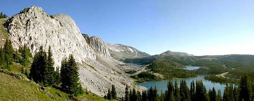 Trail view of Schoolhouse Rock, The Diamond & Old Main
The nearby towns of Laramie, Centennial and Saratoga offer camping and lodging facilities. But, there are campgrounds close by also. You can find out more information about these by clicking on the links below:
National Forest Camping in the Snowy Range Area
Medicine Bow National Forest Campground Guide
Resource Links
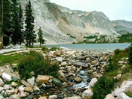 Lake Marie Outlet Stream - French Creek
Forest Supervisor's Office
2468 Jackson Street
Laramie, WY 82070-6535
Phone: (307) 745-2300
TDD Phone: (307) 745-2307
Fax: (307) 745-2398
Hours: 8 a.m. to 5 p.m. Monday-Friday (8 a.m. - 4:30 p.m. during winter)
The Supervisor's Office is co-located with the Laramie Ranger District office.
Brush Creek/Hayden Ranger District
5556 State Highway 130 PO Box 249
Saratoga, WY 82331 Phone: (307) 326-5258
Fax: (307) 326-5250 Hours: 7:30 a.m. to 4:30 p.m. Monday-Friday
Telephone for the Hearing Impaired 307-745-2307