
-
 7590 Hits
-
 84.27% Score
-
 18 Votes
|
|
Mountain/Rock |
|---|---|
|
|
41.40497°N / 106.23918°W |
|
|
Hiking, Scrambling |
|
|
Summer |
|
|
11125 ft / 3391 m |
|
|

Overview
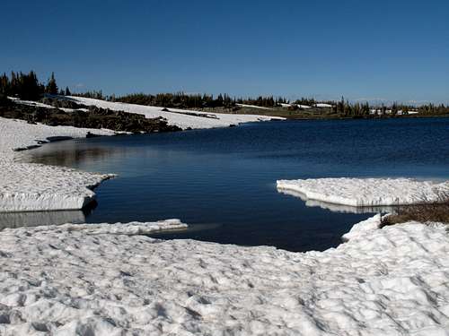
The sight of Rock Creek Knoll is not going to inspire too many people. Although it is not as ugly as some tree-covered bump, a summit "graced" with towers and antennae, or a mountain with a road to its top, it is not exactly something people are going to photograph in order to capture the wild, awesome beauty of the mountains.
But Rock Creek Knoll, joined to the better-known peaks of Wyoming's dramatic Snowy Range by a long, gentle ridge between it and Browns Peak, is an easy climb in a spectacular alpine setting and offers seldom-seen views the range's highest peaks. It also comes with a near-guarantee of solitude in an area that has a very popular trail system and whose highest peak, Medicine Bow Peak, can be crowded on a nice summer day.
Aside from the views of its neighbors, Rock Creek Knoll, on clear days, offers views south to Rocky Mountain National Park, where the Mummy Range, Longs Peak, and the Never Summer Range are visible; southwest to other sections of the Medicine Bow Mountains, and north and east across the expanse of the Wyoming Plains.
So where are pictures of those seldom-seen views, Bob? Well, as I climbed the peak in the late afternoon and the nearby peaks are to the west, if I'd taken any pictures, they'd have been nice shots of the sun. So go see the views yourself; it's probably better that you can't see them here.
Getting There
From WY 130, take the signed turnoff for Brooklyn Lake and Mountain Meadows Cabins. This turnoff is 33 miles east of the junction of WY 130 and 230 (this junction is between the towns of Riverside and Saratoga) and 8 miles west of Centennial.
Drive almost two miles on this good gravel road to a parking area on the left overlooking Brooklyn Lake. The signed trailhead for the Sheep Lake Trail is on the other side of the parking area.
Note: WY 130 is closed in winter and usually does not open until around Memorial Day; it usually closes in October.
Routes

Expect 4-5 miles round-trip, with about 700' of elevation gain.
There are two good routes. I suggest using the first for the ascent and the second for the descent.
Direct
This route is shorter and more fun since it offers some scrambling, but it does have a drawback.
Hike to beautiful North Twin Lake, which is about 1.5-1.75 miles from the TH. As you crest the rise just before the lake, you will see Rock Creek Knoll to the north beyond another rise. Follow the trail to the top of that second rise and then strike out cross-country to the base of the peak. You will be crossing delicate tundra meadows with few large rocks for stepping on; if traveling in a group, spread out to avoid wearing a path into the tundra.
From the base of the peak, scramble up the face (Class 3 at most unless you really try to make it harder) to the summit area and then hike a short distance to the summit cairn. There is no register.
The drawback of this route is the crossing of Rock Creek. The creek is not very swift, but it is wide and can be waist-deep or deeper, and finding a shallower spot to cross may take a little time. Unless it is late summer of a dry year, expect any crossing to be at least knee-deep. Also, the area immediately around the creek is boggy and has a lot of low-growing willows.
Browns Peak/Rock Creek Knoll Ridge
This way is a little longer but avoids the deep creek crossing, though conditions may require shallow crossings, especially in early summer. The off-trail portion is Class 2. Keep hiking until the trail crests the ridge (it is so broad that it is hard to think of it as a true ridge) and then hike off-trail to the summit. You will pass a pair of very pretty lakes at the head of Rock Creek.

Altitude and Weather
The hikes and climbs in the Snowy Range tend to be short, but most of them begin between 10,400 and 10,800'. Take this into account before you start; if you are not acclimated, you will likely be sucking air and have a headache (or worse).
It goes without saying that weather in the mountains is unpredictable, but the weather in the Snowy Range seems especially volatile. I have been there seven times spanning 12 total days, and only on 4 of those days have I not experienced storms or the real threat of them. It is not uncommon for dark storm clouds to fill the sky before 10 A.M. Because you reach treeline so quickly in this range, you are more exposed to lightning, and with fewer retreat options (the only comfort is that short hikes and climbs mean short return trips to the car, though that is little comfort if a thunderstorm hits you when you are on the ridgetops at 11,900').
Red Tape, Camping, and More Information
No official red tape. Take care on the fragile tundra and stick to the drier, rockier areas as much as possible. The area is a haven for mosquitoes, so bring DEET or prepare to do a lot of swatting and scratching.
There is a campground at Brooklyn Lake, and the fee is $10 a night. Reservations can be made at recreation.gov. In heavy snow years, the campground may not open until August if at all. For example, in 2009, it was still closed as of July 8.
Backcountry camping is free and does not require a permit. Please try to camp on previously used sites or in spots that are more durable (i.e. not on the tundra).
Medicine Bow National Forest