
|
|
Mountain/Rock |
|---|---|
|
|
43.91670°N / 122.1135°W |
|
|
Lane |
|
|
Hiking |
|
|
Spring, Summer, Fall |
|
|
5795 ft / 1766 m |
|
|

Overview

This is another mountain that you cannot see from the road. A forested area that helps to hide its mountains very nicely, you also find that there isn't much of a view from the summit which is a shame as there would be terrific views of the Sisters and other Oregon mountains were it otherwise. You can get a few narrow glimpses of these peaks through the trees but the views are limited.
Best to visit in late spring to the middle of fall. Snow will be plentiful in early spring and unless you are into snowshoeing, you will enjoy this one most when the trail is accessible.
Getting There
 Map
Map  Covered bridge
If you are coming from Oakridge on Highway 58, it is 31 miles from to the Box Canyon Campground and Guard Station. Don't be in a hurry, this is a slow road, paved all the way but windy and few places to pass.
If you are coming in from the north via Highway 126, watch for signs indicating the Cougar Reservoir and turn south on Oregon highway 19 . If coming from Eugene on 126, it is located 4 miles east of Blue River (between mileposts 45/46). Highway 19 twists and turns its way for 30 miles to Box Canyon Campground and Guard Station. Like the southern part described from Oakridge, this is a slow road if you get behind a motor home or trailer since there are few places to pass. At least it is paved all the way.
Another view of the Westfir covered bridge
 Covered bridge
Red Tape
Administered by the Willamette National ForestWillamette National Forest
Supervisor's Office
211 E. 7th Avenue
Eugene, OR 97401
541-225-6300
Northwest Forest Pass needed? NO
Wilderness: Self issue permit needed? NO
Wilderness: Limited Entry permit needed? NO
Information on the Box Canyon Guard station (it is for rent)
Camping
Campgrounds are plentiful in the area and the trail takes off from the Box Canyon campground, a campground oriented to the horsey set (for those with horses of courses) When you arrive at the Box Canyon Campground, you will note it is designated as a horse campground but most likely you will find that there are plenty of spaces to camp even if you don't have a horse. We were the only ones camped at the campground the night we stayed there.Box Canyon Horse Camp
Across from the campground entrance is the historic Box Canyon Guard station cabin, restored to allow for renting by interested people and sleeps 4-6. It rents for 25 dollars a day and you can get rental information by calling the Blue River Ranger station at 541-822-3317. When Bob and I were at the campground, we noticed that a couple had rented the cabin and were in the process of getting some firewood into the cabin. Looks like a good option to camping if you are so inclined.
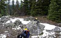
The hike

Head north from this junction to a point along the trail where you can start to go cross country to Pt. 5795, which is So. Chucksney Mountain. Do not confuse the marked Chucksney Mtn with Pt 5795 as while this mountain is worth a visit, it is about thirty feet lower than Pt. 5795 (So. Chuksney Mtn). I hope that is clear. After crashing through the bushes for a bit, you will come to a clearing that has a some rocks that serve as the high point. Look for a register left in 2006 by John Vitz. No benchmark was located. Views were minimal due to the height of the trees in the area but we did capture glimpses of the three Sisters to the east.

The hike: Yes, this one has a nice hike to it. It is ten miles round trip to the summit area with 2200 feet of elevation gain. Allow for about 4 1/2 to 5 hours for the round trip, a bit more if you decide to add Chucksney Mtn to the mix. William Sullivan has a trail description to Chucksney Mtn in his book, "100 Hikes in Central Oregon Cascades" but he isn't aware of the status of the higher mountain just south of Chucksney Mountain.
Sullivan describes the hike as a loop and his description provides good supplemental information to this page. No mention of course is made of the summit of So. Chucksney Peak and it is probable that he was unaware of it. although he most likely noticed the "5795" on the topographic map.
The weather

Peakbagger link
For more details on this prominence peak, click HERENote: John Vitz found my business card under one of the summit rocks and placed it in a register that he left. Would some future visitor note the date of June 19, 2005 on the card or on the register for Bob and I ?
Nearby Chucksney Mountain
The views are from this mountain and it is worth the extra effort to go visit the summit.L.A. Price has a couple of nice pics taken from the top of Chucksney Mountain that gives a feel for this one as a viewpoint.
Pic One
Pic Two
A trip report about a hike up to Chucksney Mountain.
Satellite view of Chucksney Mountain
