
|
|
Mountain/Rock |
|---|---|
|
|
42.49607°N / 120.87743°W |
|
|
Lake |
|
|
Hiking, Mountaineering, Scrambling |
|
|
Summer, Fall |
|
|
8370 ft / 2551 m |
|
|
Overview
Gearhart Mountain is high-elevation mountain located in south-central Oregon. The peak is the centerpiece of its namesake wilderness, Gearhart Mountain Wilderness Area. In regards to peakbagging, Gearhart Mountain is perhaps most notable for being the most prominent point in Lake County, the 10th-most prominent point in Oregon, and the 67th-highest peak in Oregon.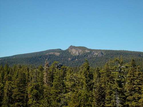 Gearhart Mountain
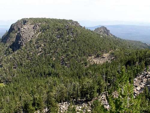
Gearhart Mountain and the surrounding terrain is full of high cliffs and rocky terrain. Ascents of Gearhart Mountain can range from low technical difficulty to high technical climbing; something for everyone.
 Some Of Many Cliffs On Gearhart Mountain
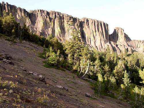
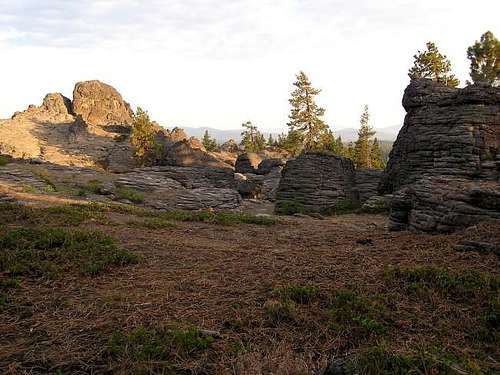
The mountain and surrounding area has been ravaged in recent years by a pine beetle pandemic which has killed many of the trees and forests. Despite this, Gearhart Mountain and its standard approaches have outstanding vistas and interesting landscapes. One of the most interesting features in the area are "The Palisades"... a series of massive volcanic rock pinnacles that are amongst the most popular destinations in the Gearhart Mountain Wilderness Area and which are encountered during standard approaches of Gearhart Mountain.
 Summit Ridge, Before Pine Beetle Pandemic Ravaged Forests
 Looking At A Section Of "The Palisades"
Gearhart Mountain has been the site of fire lookouts for many years. Fire lookouts were first established on the mountain during the 1920s. During 1935, a L-5 cab lookout tower was constructed on slopes north of the summit. During the 1950s, the L-5 cab was replaced by a 10'-tall treated-wood R-6 lookout tower. In recent years, several sources have claimed that the lookout tower is no longer present; the Bald Butte Lookout Tower, located approximately nine miles NE of Gearhart Mountain, is currently used as the primary fire lookout overseeing much of the Gearhart Mountain Wilderness Area.
 Gearhart Mountain Lookout Tower, Circa 2004
Getting There
FROM KLAMATH FALLS, OR:
1) Drive east along Highway 140 for approximately 50 miles.
2) After 1.4 miles beyond the town of Bly, turn left onto Campbell Road.
3) After 0.5 miles, turn right onto Forest Road 34 (paved).
4) After approximately 14.7 miles (only 0.2 miles beyond/east of Road 34's intersection with Road 3660), turn left (north) onto Forest Road 12.
NOTE: Forest Road 12 is shown on some maps as Forest Road 3621). Forest Road 12 leads to both the Corral Creek Campground and Gearhart Trailhead.
5) Follow Forest Road 12 approximately 1.5 miles to the road-end parking area. The Gearhart Trailhead is located on the left (west) side of the parking area.
------------
FROM LAKEVIEW, OR:
1) Drive west along Highway 140 for approximately 30 miles.
2) Turn right (north) onto Forest Road 3660 (paved).
3) After 14.2 miles, Forest Road 3660 intersects Forest Road 34. Turn right onto Forest Road 34.
4) After 0.2 miles, turn left (north) onto Forest Road 12.
NOTE: Forest Road 12 is shown on some maps as Forest Road 3621). Forest Road 12 leads to both the Corral Creek Campground and Gearhart Trailhead.
5) Follow Forest Road 12 approximately 1.5 miles to the road-end parking area. The Gearhart Trailhead is located on the left (west) side of the parking area.
Standard Approach
The standard approach for Gearhart Mountain is from the east, originating at the Gearhart Trailhead (~6200' elevation).1) Hike along the Gearhart Trail, entering the Gearhart Mountain Wilderness Area.
2) After 0.7 miles, the trail passes through one of the more interesting geological areas of Oregon, "The Palisades". The Palisades are numerous massive volcanic rock pinnacles found in the southeastern region of Gearhart Mountain Wilderness.
 A Section Of "The Palisades"
3) After four more miles (4.7 miles from the trailhead), the Gearhart Trail reaches a high saddle (~7925' elevation). The summit can be seen in the distance, still over 1.5 miles away.
4) Once at the saddle, leave the trail and head left (west) towards the southern end of the nearby cliffy ridgeline. At the base of the ridge, side-traverse leftward until finding a steep but straightforward Class 2 section leading to the ridgetop above.
5) Once on the ridgetop, hike northward along the ridgetop. In general, follow the ridgeline approximately 50 yards (left) from the eastern side/cliffs.
 First Clear View Of Gearhart Mountain From South Ridgetop
6) Approximately 1/3 along the ridgetop, a massive rock pinnacle/gendarme is encountered. At this location, most summiters scramble downhill and then traverse around the right (east) side of the gendarme to get around it. Some people might opt to traverse far to the west down the ridge slopes to go around the gendarme.
 Rock Pinnacle/Gendarme On South Ridgetop
7) Once beyond the gendarme, the summit ascent becomes much broader and straightforward. As with the first part of the ridgetop ascent, remain on the left side of the ridgeline to avoid cliff areas.
8) Eventually, partially ascend and pass by a false summit prior to reaching the true summit (8370' elevation). The true summit has several USGS Benchmarks.
 USGS Summit Benchmark
------------
An alternate, albeit more technical, approach is to continue northward along the Gearhart Trail from the saddle. After 1.3 miles, the Gearhart Trail reaches an obvious notch below the true summit cliffs. At the notch, begin climbing Class 3 and Class 4 rocky cliffs to the summit. Some faint old tracks might be seen intermixed in the rocky terrain. Some people using this route variation opt to continue traversing right from the notch, passing by three gullies before heading up steep-but-loose Class 3 slopes to the summit.
Red Tape
Gearhart Mountain is located within the Gearhart Mountain Wilderness Area. Group size in the Gearhart Wilderness is limited to 10 persons and pack animals. Dogs are not allowed.A Northwest Forest Pass (parking permit) is currently highly recommended, but is rumored to be required sometime in the future. Contact the Bly Ranger Station for current trail and parking regulations.
The Gearhart Trailhead is usually reachable by most street legal vehicles, although occasionally small drainage ditches cross the road which might prevent low-clearance vehicles from driving through.
When To Climb
Gearhart Mountain is typically only summited from Summer through mid-Autumn. This is because snowpack typically begins during October and lasts until mid-July. The closest approach roads to Gearhart Mountain area usually snowed-in from late Autumn through late Spring, too.Camping
Backcountry camping is allowed in the Gearhart Mountain Wilderness.However, there are few water sources (creeks) in the area, especially near the Gearhart Trail.
The Corral Creek Campground (0.2 miles before the trailhead on Road 012) is the closest official campground and has approximately six free sites.
Mountain Conditions
Bly Ranger District:
Located along Highway 140.
PO Box 25, Bly, OR 97622
TELEPHONE: 541-353-2424
Brian Jenkins - Sep 3, 2003 11:22 am - Voted 10/10
Untitled CommentClimbed this 9/1/03 in close to 100 degree heat at probably the driest part of the year and there was plenty of water available in the basin below the summit cliffs. Large meadows with running creeks ran all around. Just bring a filter. There was even a few running streams on the path between the trailhead and the saddle too.
Violette - Jul 6, 2020 6:04 pm - Hasn't voted
Gearhart Hike to Blue Lake July 2020Camped at the Corral Creek Campground and started the trail at 7am. July 3, 20. Headed to Blue Lake. (Shuttled a car at that trail head.) Gearhart Trail was great to No Name Pass and down to the valley. Water was available. Beautiful flowers. Amazing views. We were able to reach the Notch at the end of the meadow with no problem. After that things got sour. Beetle kill has caused the lodge pole pines to lay like pickup sticks all along the trail. We had GPS which saved us. No trail maintenance has been done in this part for years it seems. It was commando style hiking for the next six miles. A mile before Blue Lake the trail got better but be ready for mosquitoes! The Lake was pretty and the rest of the trail was fine. Had we known we would have turned around and gone back at the Notch. Palisades are worth seeing if you only want to do a mile up.