
|
|
Mountain/Rock |
|---|---|
|
|
42.10000°N / 118.6486°W |
|
|
8632 ft / 2631 m |
|
|
Overview
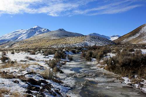 Pueblo Mountain from Little Cottonwood Creek
The fault block tectonics that created the mountain ranges of Southeast Oregon sculpted some of the most dramatic relief changes in the entirety of the state. Oregon's bleakest depression, the Alvord Desert, is ringed by spectacular escarpments especially along its western edge. In the north is majestic Steens Mountain, and dominating the horizons of desert settlements Fields and Denio is the lone giant Pueblo Mountain. The highest peak in the Pueblos Range, Pueblo Mountain is Southeast Oregon's second highest mountain, and is #20 on the Oregon P2K list with 3035 feet of prominence. Standing alone, Pueblo Mountain is the only high peak that does not lie along the West Pueblo Ridge.
No trails exist to the summit of Pueblo Mountain, route finding is merely a matter of going uphill until that is no longer an option. No trees exist on Pueblo Mountain, only in the lower gulleys such as Arizona and Cottonwood Creeks where you will find aspen, willow, and some cottonwood trees. Plant life on Pueblo Mountains upper reaches is limited to bunchgrasses, so you will be navigating a mountainside devoid of anything larger than stunted sagebrush and Lichen encrusted boulders. Expect to see Antelope here, and if you are lucky Bighorn Sheep are occasionally sighted in the Pueblo Mountains.
For hot spring lovers, several undeveloped thermal areas are located north of the mountain. There is nothing like a good soak after a long hike. Alvord Hot Springs has a bath house of sorts, but its pretty hot! Mickey Hot Springs has no bathing potential but has very pretty pools and (if its been wet enough) an active mud pot. Bog Hot Springs around the southern tip of the Pueblo Mountains is easy to access and is pretty much a warm water creek.
Getting There
The closest town of any size is Winnemucca, Nevada, which is located 164 miles east of Reno on Interstate 80. From there follow US 95 for 22 miles north, then turn left onto State Route 140 and proceed 65 miles to Denio Junction. Then follow State Route 292 north for 3 miles through the border town of Denio and on into Oregon.Continue north another 11 miles and watch for a primative road leading towards the peak on to the west. This road climbs to an old mine site at the 6600 foor level of Pueblo Mountain, a good starting point for the climb. A fork in the road also circles around the north side of the mountain. This primative road reaches the 7000 foot level on the west side of the peak, but finding your way is more difficult. The scenery there is better though, with groves of aspen and meadows.
 Pueblo Mountain North Slopes
Many who climb Pueblo Mountain will be coming from Burns in the north. Burns a modest community of 3000 residents is 130 miles ESE of Bend, 126 miles WSW of Ontario, and 197 windy arduous miles south of Pendleton. From there, follow State Route 205 south for about 60 miles to the small community of Frenchglen, which has a store, gas station, post office (all in one, but not always open!), and a nice historic hotel. Continue south on Route 205 for another 58 miles to Fields which has full services and is generally open 7 days a week. About 9 miles south of Fields, the primative road turns off to the west.
Most Pueblo Mountain climbers utilize the North Ridge Route or some variation of it. Arizona Creek draining Pueblo Mountain's north slopes has a rough 4x4 road travelling up it, the further up this road you are able to drive the closer to the summit you get. One word of caution, this is a narrow and rough road. Anytime you are in this region its always a good idea to bring at least one spare tire and to travel at low speeds.
Red Tape
Much of the Pueblo Mountain Range is BLM land and is open to cattle grazing.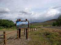 Pueblo Painting at old gift shop
Burns BLM: (541) 573-4400
Always have at least one spare tire when traveling in the Pueblo Mountains, all roads are in poor condition and the nearest tire repairs can be done is over 100 miles away in Burns or Winnemucca.
When To Climb
Pueblo Mountain is accessible year round as the Fields-Denio Road runs along the eastern base of the mountain.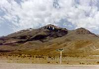 Classic Pueblo Shot
February through Early May can be a great time to hike in the area. In early season you may contend with varying snow levels on the mountain, though the snow tends to only accumulate at higher elevations (6000 feet and higher). By May, Rattlesnakes will be emerging from hibernation and early summer lightning storms become the primary obstacle to hiking in this region. It is quite common for lightning storms to run the length of the Alvord Desert raining down on surrounding mountain tops each and every day beginning in mid-May and running into August. Fall brings hunters to the high desert, and the darkest months of winters bring extreme low temperatures to the region.
Camping
The basin between Pueblo Mountain and West Pueblo Ridge has many nice campsites where you are sure to be alone. Little Cottonwood Creek, which is 2.25 miles north of the Arizona Creek on the east side of the mountain, also makes a good (except for the lack of shade) campsite. The summit is flat and spacious, but lightning storms are common in the spring and summer. Also worth considering are campsites along Little Trout Creek, Bog Hot Springs around the southern tip of the Pueblo Range, or maybe even Pike Creek up on the Alvord Desert.Mountain Conditions
 Pueblo and West Pueblo Mountains seen from Long Hollow Pass
Other Links
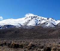 Typical Winter Snow Level
 | 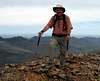 |  |  |  |