
-
 3470 Hits
-
 72.08% Score
-
 2 Votes
|
|
Route |
|---|---|
|
|
46.46320°N / 13.69650°E |
|
|
Hiking, Mountaineering |
|
|
Summer, Fall |
|
|
Most of a day |
|
|
Walk-up, easy climb |
|
|
Approach
The trailhead starts in Tamar, where at the end of the road into Planica valley the mountain hut stands on 1108 m. The hut is reachable by car outside winter season. In winter a cross-country ski track goes there.
Route Description
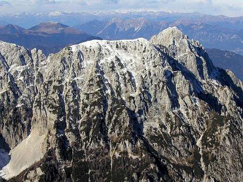
First ascent: Julius Kugy and Andrej Komac, 1897.
From Tamar hut we continue up the valley, but only a few minutes. There to the right our trail on Srednja Ponca branches. Our route uses a ravine, going towards two distinct big caves (the left one is vertical, the right one horizontal). Below the right cave the path turns left and climbs into another, grassy and rocky ravine. The path is not strong, but well marked. Ascending by it, we reach out of woods on a ridge above the broad basin, extending below the walls of Strug and Ponce. Below last larches there's a nice place to rest.
After this point we continue, gain some more altitude and then the path turns to the right and starts ascending far across the slopes of Zadnja Ponca. There's the first more demanding section, where the path is protected by cables. Traversing the slopes towards the N continues and on some 1970 m we reach the second more demanding section. There the trail is already weak, but marks are still reliable. Soon after that the trail turns left, more or less directly up the steep summit slopes. They are rocky and rugged, use the marked passages. So we reach the main ridge and immediately after that to the right the summit.
From Srednja Ponca we continue by the main ridge towards the north. First we descend to the notch (Planiška skrbina, 2156 m) and beyond it climb a good 100 meters more to the main summit. The route is marked and secured, but exposed and needs some experience (ferrata). When on the ridge, take care if weather is deteriorating (lightning!). From Tamar cca 4:30h.
Essential Gear
Good shoes, telescope poles.
Rating the Route (by hiking standards)
Overall: Not hard, but quite steep terrain requires reliable step and keeping to the marked path. A few exposed places on the ridge. Hot, no water.
0. General: 1108 m to 2274 m, exposition SE, marked, steep path, on most exposed passages protected rock route.
1. Effort: 1200 m, 4 h 30 min.
2. Power: 3 - medium (only the short summital part).
3. Psyche: 3 - medium.
4. Orientation: 2 - easy.