
|
|
Route |
|---|---|
|
|
31.92354°S / 70.08519°W |
|
|
Hiking, Mountaineering |
|
|
Expedition |
|
|
40 degr. snow climb |
|
|
Overview
 On the face
Trabante II's south face is not more than 300 meters high and most of the way it's an easy walk on snow. The reward of climbing the peak is excellent views of the nearby Mercedario - South America's 7'th highest peak of 6700 meters. The long east ridge as well as the actual summit is hard to see in such a good way from anywhere else. The climb itself is perfect for acclimatization before attempting higher peaks in the area and it's one of few on the nothern side of the Mercedario massif.
Getting There
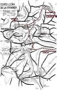 A map of the area
For a detailed explanation on how to reach the peak;look on the main page.
In short.
Argentina - Mendoza - San Juan - Barreal.
By jeep of hitchhiking to Las Juntas.
Alternative 1 - Via Las Molles.
Go by road to Las Molles (at the moment completely wrecked) mining camp. Walk up the narrow Laguna Blanca gorge. Pass the lagoon and continue on the old abandoned road until you see Mercedario. **Go along a good path, until you reach an altitude of about 4850 meters where the path takes a 90 degree turn to the left towards Mercedario. This is a good place to camp. On your right/south you can see the snowy face of Trabante II.
This alternative is no good at the moment, due to a flash flood which swept away the road close to Las Molles.
Alternative 2 - Via Valle Colorado.
Start walking at Santa Ana police post. There are good walking paths all the way to Mercedario's south face base camp. Cross Paso Ancho (4700m) and descend to the old abandoned mining road. Cross it and walk over some low ridges north. Descend into a valley, where you'll find the normal walk in path to Mercedario's normal route. Walk up vallley until and follow the directions given above. Same as from the "**-mark".
Route Description
 Summit view to the west
If you're well acclimatized, count on climbing the peak in about 2 hours (up and down).
There are some nice small streams close to the camp spot at the foot of the peak. Walk over the little bowl and aim for the highest point on the face. The first part is on a low gradiant, but it gets steeper after about 50m. When you have climbed about 2/3 of the face, there's a short section of about 40 degrees.
It flattens out the last part and when you have reached the summit ridge, you'll realize you have reached a false summit. The highest point is located about a 100m east. If there's bad visibillity when you're up there, don't stray too close to the northern edge of the ridge. The rocks are loose and the drop is long.
If you're a hiker and want to summit the peak, there are very easy alternatives, staying close to the east or west ridges leading to the summit.
Essential Gear
Warm and wind proof clothing.Sun glasses.
Snacks and water.
A trekking axe.
Crampons.