
|
|
Mountain/Rock |
|---|---|
|
|
31.92354°S / 70.08519°W |
|
|
Hiking, Mountaineering |
|
|
17224 ft / 5250 m |
|
|
Overview
There are a lot of peaks to climb on the southern and western side of Cordillera De La Ramada. La Mesa, Ramada, Polaco, Negro, Alma Negra and of course Mercedario and its amazing south face. If you head for the normal route (east-north) on Mercedario, via Las Molles there are very few other climbs to attempt. One of the few is Trabante II (pronounced Trabante dos), a little peak with a snow covered south face. It’s not a technical climb and is suitable for any kind of hiker or climber.Trabante II is the highest peak in a small sub-range consisting of three peaks; Trabante I, II and III. Number II is the highest and the center piece in the ridge. It is also the most accessable as it is located close to Mercedario’s normal walk-in route. From its summit you can see the deep valleys of western Argentina, which continues into Chile. To the east you have splendid views of the Laguna de Rio Blanco. It’s also a spot from where you have excellent views of the higher reaches of Mercedario and its sub-peak Pilar Grande.
From Campo de Mulas, which is usually called camp 2 on Mercedario’s normal route, an ascent of Trabante II is both rewarding and easy. The altitude gain is only 300-350m and can be done as a half day hike. Some groups have used is as an acclimatization peak from Camp 1 at 4400-4450m, but then it’s a long and taxing venture. The climb itself can be done in two ways.
Either go straight up the snow/ice face directly to the summit, or scramble up on any of the ridges. The face is about 40 degrees at most and require a little bit of experience of walking with crampons and self arrest technique. The ridges any hiker can do.
Getting There
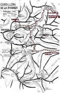 A map of the area
Under normal conditions, access to Trabante II is a quite straight forward undertaking. Since a lagoon collapsed higher up in Los Andes and created a huge flashflood, which swept away the road it’s a complicated or/and dangerous task to get to the peak.
There are two main options.
1. The normal route to Mercedario via Las Molles.
2. The walk in via Valle Colorado and over Paso Ancho to the massif’s north east side.
Both access routes will be explained further down, but first a general description on how to get to the area.
To Barreal
The main city in this part of Argentina is Mendoza. It’s easy to get there from both Buenos Aries and Santiago, the capitals of Argentina and Chile.
You can either fly from Buenos Aries or go any of the many long distance bus companies to Mendoza. This option is completely hassle free.
There is an issue if you go through customs at Santiago airport: there is a good chance that you will have all meat and dairy products from your expedition food confiscated upon entering Chile. Stay in transit and take a short (45 min) flight on Lan Chile or Aerolinas Argentina to Mendoza, Argentina. This will allow you to keep your food, get your permits, possibly see Aconcagua from the air as they fly close to it at times, and save the 100$ U.S. tax Chile imposes on all Americans, Canadians, Mexicans + a couple of more nationals. Chile has made things difficult for climbers (particularly those on a budget) with this tax and with the food issue.
It is recomended to fly to Mendoza as direct as possible.
You can also take the bus from Santiago to Mendoza, which is a scenic journey over Los Andes.
Take a local bus from Mendoza to Barreal. You may have to change bus in San Juan and in total it takes 4-6 hours, depending on which connection you choose.
Some helpful people can be found at the Andesmar bus company in Mendoza. Claudia Yanzon is who to ask for. She speaks English and has connections in Barreal with those who deal with climbers.
 On the approach via Mercedario's normal walk-in route
Getting to the mountain
You can either hitchhike through the desert to Las Juntas or rent transport. The normal drop off points are either at Las Juntas bridge, Santa Ana checkpoint or even Las Molles. There are communications systems in all these places, so you can call for a ride back.
If you hitchhike, be prepared for long waits. There are only a couple of cars a day. Water is never further than a km away on the road’s left hand side. It’s very hot in the area, so bring lots of water and be prepared for being blasted by the sun.
1. Directly to Trabante II via Las Molles.
The road was swept away by a disastrous flashflood in late 2005. You can still make it to Trabante II this way, but consider it a very hard option. I don’t recommend it to anyone. The following info is about the route Under normal conditions. Let’s hope the road will be fixed soon.
Get a hitch or go with a rented vehicle to Las Molles. From there you either walk or ride on a mula up a steep valley to Laguna Blanca. Some km after the end of the lagoon, there’s a refugio. Continue on the abandoned mining road until you arrive at some lush meadows. Here you’ll find some rock shelters and a road towards Mercedario (right). Follow the little trail along a river. There are plenty of very good campspots along the way. There’s one steep section, many times covered with large penitentes fields. When you have reached the top of it, a wide valley appears. On your left you can see parts of the Mercedario massif and on the right you have the small Trabante chain. When reaching about 4800m the valley is about to end. There are small tent platforms here and the main trail continues up towards Mercedario. On your right there’s a little peak with a snowy south face; Trabante II.
 Close to Paso Ancho, looking back into Valle Colorado
To Trabante II via Valle Colorado and Paso Ancho.
Part I.
There are two options on how to walk to Campe de Los Polacos, which is the first stop of the walk.
1. With mules and/or with low water levels in Rio Colorado, you can cross the river at three places and walk on a good path all the way.
2. If there's a lot of water in the river and you go without mules, you may have to walk all the way on the left hand side of the river. This is rough and hard and expect some hairy parts with steep scree and even some short passages with easy rock climbing.
If you go with mules or is a strong walker and choose alternative one, you can reach base camp "Campo de los Polacos" in a long day. 10-12 hours.
If you have to go for alternative two, expect two days to reach base camp. The first stretch is easy, followed by rough terrain and finally some easy walking again, when the valley opens up. You’re now at Mercedario’s famous south face and Campo de Los Polacos.
Part II.
From base camp/Campo de Los Polacos walk straight over the wide river valley towards and obvious opening in the Negro ridge. Head up the steep scree slopes until they get less steep. There's a small spring here where you can fill up your water bottles.
The main horizon ridge is black/grey in color, the next below is red and the lowest one is yellow.
You have two alternatives.
1. Walk up to the gap in between the red and the yellow ridge and turn right. This route is less steep and is the most commonly used. There's a very clear and present danger of rock avalanches here so don't attempt this route if it has been raining!
In the end it joins alternative 2 (described below) and the final part is the same to the pass.
2. Look for guanacos trails before the yellow ridge. They are sometimes very steep and exposed. be very careful in some places. The route is obvious at most times and the trails are easy to find. Also, there's only one way up the connecting valleys.
After an exposed and very steep section, with possible penitentes fields at about 4500m, you can see the pass and the ridge. Unfortunately you can also see traces of mud/sand/scree slides and rock avalanches. Pass this section as fast as you can and don't even consider going on if raining!
When you have passed the dangerous section under the rock towers and big boulders aim up towards the lowest point of the ridge.
A little cairn at the foot of some rock formations marks the Paso Ancho.
 Penitentes fields on the walk-in
Walk towards the foot of Negro. Cross some penitentes fields and pass in between Negro and Wanda.
There are excellent campspots here.
Head for the left hand side of the valley and walk on a wide ridge until you see the valley on the other side. There are many slopes leading down to the mining road far below. Go for one which you find suitable. Guanacos trails will guide you. When on the road, you can see rivers with fresh water in the valley below. Either head down to the grassy fields further down or traverse straight over the ridges which finally takes you to the normal route of Mercedario and Trabante II.
If you go down all the way to the grassy fields, you'll loose about 300m of altitude (3700m). The road is at about 4000m, depending on where you hit it. The ridges you have to traverse is at about 4200m.
Expect a 10 hour day from base camp to the grassy fields on the other side. Don't take this traverse lightly. I would say it's harder, more exposed, filled with more objective danger and is more of a challenge than climbing Ramada and Mercedario.
If you go all the way down to the grassy fields, you connect to the path to Mercedario and Trabante II there. If you opt for traversing the ridges from the mining road it’ll be higher up. If you can’t locate the path, walk over all the way to the far side and you’ll hit it sooner or later.
Red Tape
There is no peak fee or other permits, but you have to register at the gendarmeria in Barreal, located in the huge army compound in the center of town. When crossing Rio de los Patos at Las Juntas, you also have to register or at least tell the guys at the river that you enter the area. 7 km up along Rio Colorado there's an gendarmeria check point in Santa Ana, there you also have to register.Camping
 Rock formation
You can camp everywhere in the area. There’s one refugio on the walk-in via Las Molles. It’s situated just a km south of Laguna Blanca along the main trail. Don’t expect to find anything here, just a roof over the head.
When Las Molles mining camp is built up again (if ever), there may be lodging available there.
At Mercedario’s south face there is a big BC tent, but it’s usually only available for paying clients.
When to climb & Mountain conditions
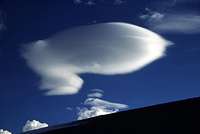 Strange cloud
Late November to late March. There can be lots of snow and the rivers can be impossible to cross outside this time. Count on annoying penitentes fields on higher elevations if you’re around early in the season.
The area has a more stabile weather than many other in the Central Andes. Sudden blizzards and rain is not uncommon, but the Katabatic winds that plague for example Cordon del Plata are not common.
It’s an area full of rivers, small streams and melt-off water and not at all like for example the dry Puna, where water always is an issue. If crossing Paso Ancho, avalanches can be a danger.
Flash floods has occurred in the area and this is a very dangerous issue if there’s heavy rain in the mountains. The valleys are deep and the rivers wild. River crossings is always a worry here.
Mulas, base camp services etc.
 Mercedario's east ridge from the summit
I’m usually not recommending anyone to use mulas (or similar help) to the mountains, but in this area it can be of great help crossing the rivers.
There's one very good organizer in the area. Contact Anibal Maturano or Celeste Arias at San Juan Aventura. They know the area like the back of their hands.
San Juan Aventura
Ruta 12 s-n Pasando Control Fitosanitario Zonda.
5401. SAN JUAN, ARGENTINA.
Ph: (+54) - 264 - 4945231
Mobile: (+54) 9 - 264 - 6711515
Fax: (+54) - 264 - 4945231
http://www.donmercedario.com.ar
NOTE: This web site sometimes doesn't perform well with Mozilla Firefox!
Expediciones Ossa (Barreal) can also arrange all details for the area.
Ramon Luis Ossa
Tel/Fax 0264-8441004
ossaexpediciones@infovia.com.ar
Casa Orviz can arrange everything for you from Mendoza. Transport, equipment, mules etc. This is by far the best gear shop in Mendoza.
Casa Orviz
Juan B Justo 532, 5500 Mendoza
Tel. 0054 261 4251281;
www.orviz.com
Accommodation in Barreal
 Looking towards Chile
There are a couple of hotel in the small town of Barreal. The most well know is Hotel Barreal.
Posada San Migual is another choice. A very old house with courtyard but very cosy pleasent but sometimes nonexistent owners.
Hotel Jorge is a shoe string priced funky old place, where you can stay for as little as $3.
There are also three camp sites, where you can stay for $1/person in a tent.
There are at least two places where you can stay in cabañas, Dona Pipa Cabañas is one I got recommended.
The high altitude
The area is of high elevation and it’s important to be very careful ascending. A lot can be said about this issue, but I think it’s better to let the pros tell you how to play it safe.The high altitude guide is a great site about the issue.
Nature
 A stream from an underground well
Cordillera de La Ramada and the surroundings is a very colorful place. It's a host for more vegetation than in many other areas in Los Andes and there are plenty of Guanacos, hares and foxes. Birds of prey, especially condors are seen on a daily basis.
The rock formations are stunning, both in shape and color. Even if you don't plan to climb any peaks, a trek in the area is warmly recommended.