|
|
Mountain/Rock |
|---|---|
|
|
40.46530°N / 112.4537°W |
|
|
Tooele |
|
|
Hiking |
|
|
Winter |
|
|
6597 ft / 2011 m |
|
|
Overview
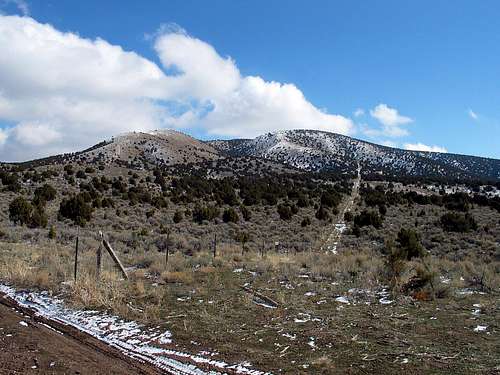
Located west of Salt Lake City, this is a little mountain that you can visit in mid winter when the snow is unstable in the Wasatch and yet you want to get a bit out of town to stretch the legs or just to see some place different. Easily approachable from Salt Lake City via I-80, it is located just south of Grantsville but I didn't even know of its existence until Eric Willhite posted a trip report on his website about this one. He stated: "South Mountain is a perfect little winter trip or a nice spring hike with the kids. The elevation is low with a route that climbs up a southwest ridgeline that melts out fast." He stated that it would be a good snowshoe trip too so that caught my attention since I'm always looking for a potential snowshoe hike that has very little avalanche danger. Thanks to SP member Eric for bringing this one to my attention.South Mountain West does have a twin called South Mountain East but the reason it was more attractive is that it is a mountain that has over 1000 feet of prominence, with 1177' to be exact. It ranks #245 on this list.
So, if you are looking for something a bit different, and to the west of Salt Lake City, this is a nice hike with good views, anytime of the year.

| 
| 
|
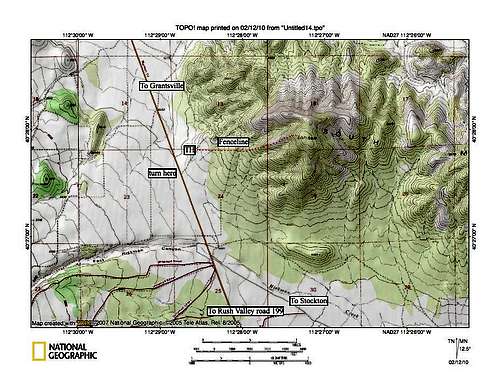
Getting There
Take I-80 west towards Wendover and take exit 84, heading south into Grantsville on highway 138. Its about 9-10 miles to Grantsville from the interstate. In Grantsville, go south on Cooley road which quickly becomes So. Willow/Mormon Trail Road and head south about ten miles to the high point of a pass that begins to drop down on the south side into Rush Valley. Just about at the highest spot on the pass, there is a dirt track that angles to the northeast and heads up the hill to a fence line. The gate is locked and no negative signage is in place. We climbed over the gate and made our way up the dirt track until we came to the fenceline. Rather than cross the fence (no gate), we headed east up the fenceline and that worked great as a route.From the south, you can either come in from Rush Valley or via Silver Ave road from Stockton.

| 
| 
|
Red Tape
I'm not aware of any problems if you stay on the south side of the fenceline but it might be private property on the otherside of the fenceline (north side). I saw no negative signs indicating that this is off limits. The gate is locked down at the highway so it is your call whether to climb over the gate and head up the road. A rancher pulled in as we were doing so and didn't indicate that it was a problem, the gate is locked most likely to keep hunters and ATV'ers off the road.Camping
Since this is really an easy day hike, I couldn't think you'd want to camp but there is a campground to the south on highway 199 (see a highway map)That campground is: Clover Springs campground near Johnson Pass. Click this LINK for an interesting photo story of the history of this campground. Clover Springs has 11 sites and charges a fee. See below:
Description: 6000 ft. elevation. 11 campsites at the northeast end of the Onaqui Mountains. The clear, bubbling waters of a natural spring gave this site its name. Cottonwood trees frame this campground which includes a trailhead for hikers and horseback riders. Group camping is available with a reservation. Additional group camping is available for equestrians.

| 
| 
|
The route
From the parking spot at the on the highway, walk up the dirt track until you reach the fenceline, then turn east along an old bulldozer type track that parallels the barbwire fence for awhile. After that ends, continue along the fenceline along a use trail and it'll drop into a draw before the fence turns northward and ends shortly after that. Leaving the fenceline, you'll be on the ridgeline with easy routefinding up the ridge to the summit area. Not much in the way of brush to deal with and when you reach the top area, summit is a very broad area that is nice and flat. I was unable to find a benchmark nor a summit register in 2009.I really enjoyed the views to the west and north. Total distance 1.50 miles,
elevation gain 1400'.
Weather
 External LinksGrantsville Utah Wikipedia link
Map