

-
 7432 Hits
-
 79.78% Score
-
 11 Votes
|
|
Route |
|---|---|
|
|
41.18600°N / 113.3675°W |
|
|
Hiking |
|
|
Spring, Summer, Fall, Winter |
|
|
Half a day |
|
|
Overview
Desert Peak has a nice route description from the east side and yet, one of the people who climbed the peak from the east, mentioned that the west side might be an easier way to climb it. In looking at topographical maps of the peak, I felt that there might be a reasonable western approach and selected the southwest ridge from an old mine area as a possibility. Three guys from Arizona tried the route and relayed the information to me that it was a "reasonable" and direct way to go. So here it is, the Southwest Ridge, hiked by MikerHiker and myself on August 18th, 2009. Normally an August day would NOT be a good time to be in this area but we took advantage of a cool spell (in the low 80's) to be there.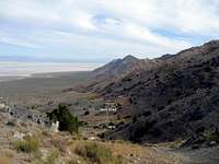
Do not venture out into the Newfoundland area after or during a rainy spell.
The roads become muddy and slimy and you do not want to get stuck out there.
Getting There
From the front page description:"From Salt Lake City: (120 miles)
Head west on I-80 towards Wendover. Continue to exit 62 (Lakeside Military Area) and head north towards the Military Area. About 15 miles from the Interstate you will reach the Military Area where the paved road bends and then continues to the military base. At this bend there is a dirt road that continues straight, follow this well-graded dirt road. After another 14 miles you will reach the railroad tracks. Continue about a 1/4 mile west to where a road crosses the tracks and follows the railroad tracks. This is where the road is marked as private. Continue west along the railroad tracks for 25.5 miles to the Newfoundland Mountains road."
 Map one
My odometer varied a bit from the above mileages but I would recommend following Greg's mileage. When you get to the turnoff that goes south across the tracks into the Newfoundland range (see map 3), you are about 8 or 9 miles from the area where I parked. However, those miles took me about 45 minutes. Follow the dirt road as it makes it way south and watch for a "decent" road that goes west. There was a metal stake placed at the right junction (GPS 002 on map 3) but no signage to indicate that particular road. Follow the road west and before long it will bend around the range and then start heading south. The key junction is shown on map 2 as 001.
If you do not have a high clearance vehicle, park near here as the road that heads towards GPS waypoint 002 gets pretty rough. You could walk from this point, just follow the road. At waypoint 002, you will see a road branching off to the right and it heads towards the old mines in the area. This is a rough road and I had a couple spots to negotiate that I know I couldn't have made past without 4WD.
We parked near the old mine area (watch for nails) at waypoint 003.
 Map 2
Map 2Route Description
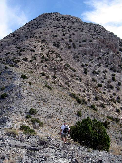
From the mine area where we parked at 5300 feet, we walked the jeep track up to a saddle where the jeep road continued on up to the right. At the saddle (5500'), go east and work your way up the steep terrain, following some animal trails that pretty much lead to the ridgeline. Avoid going to the north as cliffs will stop you so continue working your way up until you come to the north south ridgeline. A few spots will require the use of hands but for the most part, it is no worse than class 2 and believe me when I say you will figure out the logical way to go as you proceed upward. Once you reach the ridgeline at 6000 feet, you will see the remainder of the route plainly before you. Another 1000 feet will put you on the summit itself.
Again, there is nothing technical about the southwest ridge, you will need to avoid a few small cliffy areas but we were able to figure out a route that took us directly to the summit. It may be steep but the footing is generally
good and straightforward.
Total mileage: 1.3 miles each way with 1700 feet of elevation gain.
Route map

Gear?
Well equipped vehicle with maybe a 2nd spare tire and lots of water. Be prepared for what to do if your vehicle breaks down out there as it is veryremote.
voxnihili - Jan 15, 2012 12:30 pm - Hasn't voted
Road ClosedAs of January 2012, the last stretch of road near the mines is marked as closed, private property. Instead of hiking the road to the saddle and then going along the ridge, we turned straight uphill (west). Steep, but otherwise not difficult.
Dean - Jan 15, 2012 4:09 pm - Hasn't voted
Re: Road ClosedThanks for that update. I'll add it to the SW ridge page. Glad you were able to go out there in January and pick that one up. Nice.
voxnihili - Jan 16, 2012 12:41 am - Hasn't voted
Re: Road ClosedIf it helps, the sign was located at 41.189288 N, 113.382172 W. By the way, thanks for the route description, it was very helpful
1L-19 - Mar 27, 2017 12:46 am - Voted 9/10
Re: Road ClosedI'm planning on going out there next weekend (4/1/2017) if the rain backs off this week. When I do, I will update if the sign is still there or not.
1L-19 - Mar 25, 2017 11:09 pm - Voted 9/10
I wanna check it outI was scoping out some possible places to go on Google Earth and ran across this area by accident and thought it looked intriguing. I was looking at going up this weekend (3/25/2017) to check it out but rain was forecast today and sure enough it rained like heck all day. I have a co-worker who is a volunteer fire/rescue guy out of Tremonton. He has helped people out who have gotten stuck out in this area and he confirmed that you do not want to be out here when it's raining. The mud is gnarly sticky stuff, you can get stuck real easy, and you don't want that in this remote area. Maybe next weekend, I'd like to try it before it gets hot.
1L-19 - Mar 25, 2017 11:13 pm - Voted 9/10
Re: I wanna check it outMy fire/rescue friend recommends that if you want to come out to this area and it's been raining, wait at least 48 hours before going and keep an eye on the weather.
1L-19 - May 5, 2017 1:15 am - Voted 9/10
Re: I wanna check it outIt's been such a rainy spring that I'm finally going tomorrow (Friday 5/5/2017) to climb the southwest route. Forecast temps are in the low 80s but will feel hot because we've had such a cool spring and the sun is supposed to be intense. I'll report back.
1L-19 - May 6, 2017 1:02 pm - Voted 9/10
Southwest route, I couldn't get thereI attempted to climb Desert Peak using the southwest ridge but I couldn't get up to the mine (more about that in a minute). I could see where I needed to get up to and it looked to be 3-4 miles away. Mapping it out on Google Earth, it was only 2. At the time, I was thinking, "It's already 3 PM and I wasn't planning on a 7-8 mile hike in addition to the climb," so I aborted. Now that I know I can get within 2 miles of the ridge, I'm going to give it another shot (if a weekend this spring isn't too hot or wait until the fall). It's all good, I did some hiking in the area and still had a great time. It's a beautiful area, especially because it's been a wet spring. I'll upload some pictures soon. Some things to be careful of: 1. There are many areas on E Newfoundland Mountain Road where there's low spots with standing water. Most of these spots have little bypass paths around them, just don't go barrelling into them. Don't just go driving into a puddle without knowing how deep it is or how soft the soil is under the water. When I was out yesterday (5/5/2017), I didn't see a single other person or vehicle out the whole day. If you get stuck, plan on being there until somebody comes looking for you or you better MacGyver a way to get your vehicle out. 2. A guy posted that he got up to the mine area in his sedan. That was 8 years ago, that's not going to happen now. It got too sketchy in my RAV4 and I didn't make it. There was a part of the road that was all loose rocks about bowling ball size and a good drop on both sides. You could do it in a truck, preferably one with a shorter wheelbase, I could see problems with a long-bed truck. There's also numerous areas where runoff water had gouged out the road, navigating through the low spots is challenging. E Newfoundland Mountain Road also has areas with large ruts that anybody without a high-clearance vehicle is going to get high-centered on. There's ways around, just be careful. 3. When coming south from Kelton, there's more than one E Hogup Road. Don't get sucked into the path that runs farther east that takes you right by the lakebad (stay west of Broom Mountain, not east!). It's scenic but the road is much smaller, is only single-vehicle width, and is extremely rough. I lost a couple hours going this way. It's a less-direct route where you can only do 10-15 MPH vs. 45-50 MPH, so it is a major time-killer. Coming back, I took the left fork (also called E Hogup Road, WTF Google Earth?!) instead of the Hogup Bypass Road that takes you right by the lakebed. You'll soon see a sign that says Kelton 41 miles. I saved major time on the way back, it was a wide road in good condition and I was able to do 50 comfortably.
MikerHiker - May 15, 2017 7:38 am - Voted 10/10
Re: Southwest route, I couldn't get thereYa that is one place that you don't ant to get stuck too, That mud out there turns to grease with a small amount of rain, I'll bet this winter we had and all the snow made for a very muddy road. The route to the western side of this mountain (if passable) is by far the best way to go, the hike is fairly easy but fairly steep.
1L-19 - Dec 1, 2017 12:58 am - Voted 9/10
Re: Southwest route, I couldn't get thereGood stuff! I'd like to re-attempt in spring 2018. The real problem is that I didn't even get out there until almost 3 PM because I got so delayed with a slow route. If I get a little bit hurt, twist an ankle or things just take longer than I thought, I could wind up coming back in the dark. REAL dark, country dark out there. Being my first time out, I did not want to take a chance on that. I see now that my post comes off really negative. That's not right. I did some desert hiking, took some pics, saw some really cool stuff, and learned some lessons about routes to take and how NOT to get out there. I still had a great time and the whole trip was really worth it. I have a friend who works volunteer Box Elder County Fire/Rescue, he's confirmed that you do not want to get stuck in the mud out in this area. He was saying that if it has rained in the last 48 hours, don't go out. He also said really watch the weather forecast and don't go if it threatens rain. I live in the Ogden area, so coming around the north or south is the same distance. Having done both routes now, I'm doing the south route. Coming up through the Military Area from I-80 Exit 62, 90% of that is paved. When the pavement ends, the road is maintained really well and you can do 50 MPH no problem. It's also not the spiderweb of dirt roads that the north route is. Coming from the south, there's exactly one route through the military area and it's obvious. To screw it up, you'll have to literally drive through a fence or run the gate to the military base (iron gate with armed guards, that ain't happening).