
|
|
Mountain/Rock |
|---|---|
|
|
49.28393°N / 20.29861°E |
|
|
Hiking, Skiing |
|
|
Spring, Summer, Fall, Winter |
|
|
4131 ft / 1259 m |
|
|
Overview
 Bucolic landscapes
 Ridge in winter
Spišská Magura is not exactly a "top", neither a "range". It's a stripe of 30km stretching on the north of the White Tatras, and south from the Slovak Pieniny.
As it name suggests, it is located in the Spiš region, "Magura" meaning "little mountain" (Hungarian name : Szepesi-Magura)
 Toward the Tatras
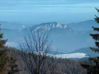 And the Pieniny...
Despite an unsignificant part of it lies on the Polish side of the border, most of Spišská Magura lies in Slovakia.
Its highest point, Repisko (1259), is not served by any marked trail, on almost all of the main ridge of Spišská Magura runs a marked trail, served occasionally from the north and from the south by side-trails.
The main ridge starts at the pass of Ždiarske Sedlo (on the main road that circumvents the Tatras between Podspady and Ždiar) and runs through the tops of: Repisko, Magurka, Bukovina, Smrečiny, Spádik, until the pass of Magurské sedlo. Some geographers consider that Spišská Magura continues further on to the East, some not.
On all its length, Spišská Magura provides stunning views to the White Tatras. If the ridge is reached from the North, the apparition of the twin peaks of Ždiarska Vidla (2146) and Havran(2152) is breathtaking. Spišská Magura is a mandatory stage for the one who undertakes a walk across the Carpathians.
The trail across Spišská Magura, despite not being explicitely marked for bikes, lies out of any national park, then is not subject to any specific regulation, and then can be cycled with a mountain bike (MBPost link). It is often mentioned to be a very rewarding trip, for example in this article of a famous Polish biking magazine (english google-translated version)
Anf finally, since I mentionned all seasons, Spišská Magura is a great place for ski-touring and cross-country sking (ridge only), if you stay a bit out of the rush of the ski lifts of the Bachledova ski station. If you plan to go on foot in winter, it's also a place to bring snow-shoes, as very few people go, and the trace often doesn't exist.
Getting There


The best base for exploring Spišská Magura is for sure Ždiar, on the foot of the Tatras. While the Tatras offer many demanding day-hikes, Spišská Magura is an attractive alternative for making relaxing familly walks.
 Bachledova dolina
Another alternative as place to base, on the north side (then, by car, in the surrounding of the Pieniny region), is the village of Jezersko (english version). Many accomodation since this pretty village hosts few lifts of the Bachledova ski station.
The map below shows the many road by which it is possible to approach the range (the B and D points being respectively Ždiar and Jezersko):
View Larger Map
Red Tape
I had some feedbacks from people who walked secondary marked trails on the north side of Spišská Magura. The trails are not very well marked and it requires a minimum of orientation skills.If you camp, beware, some bears live in Spišská Magura...
 wild Spišská Magura
Map
A map on the excellent site http://mapy.mk.cvut.cz/ :
Unfortunately not all the surface of Spišská Magura is not covered by this map, the far east end is missing.
yatsek - Apr 25, 2009 8:13 am - Voted 10/10
Magura Spiska ProperThe page is about the Magura Spiska "Proper" but in fact, the rather Slovak word "Magura" seems to be a synonim for the Polish "Pogórze". And the term "Pogórze Spiskie/Magura Spiska" is also used to name the whole area east of the Białka River. It's a bit like the Beskid Żywiecki/Oravske Beskydy problem - there are different names on either side of the political border splitting quite a homogenous region.
visentin - Apr 27, 2009 7:22 am - Hasn't voted
Re: Magura Spiska ProperMy page is not about all the region, but about Magura Spiska as the map shows, just the long hill that runs north from Zdiar.
yatsek - Apr 27, 2009 9:38 am - Voted 10/10
Re: Magura Spiska ProperThat's exactly what my addition reads :)
visentin - Apr 27, 2009 5:03 pm - Hasn't voted
Re: Magura Spiska Properhopefully I'll ride it by bike in the beginning of June !
yatsek - Apr 28, 2009 3:09 am - Voted 10/10
Re: Magura Spiska ProperI hope you will, and I hope I will - a bit later :) although at the moment I can hardly ride 80 km while 4 years ago I did 160 :(
visentin - Apr 28, 2009 3:47 am - Hasn't voted
Re: Magura Spiska Proper80 is not bad at all ! road of MTB ?
yatsek - Apr 28, 2009 5:21 am - Voted 10/10
Re: Magura Spiska ProperRoad, unfortunately :( - my bike's no good for off-road but excellent for road: 28", bald tyres :)