
-
 3842 Hits
-
 82.48% Score
-
 15 Votes
|
|
Route |
|---|---|
|
|
46.33084°N / 12.25989°E |
|
|
Trad Climbing |
|
|
Summer |
|
|
A long day |
|
|
ED-, VII (VI+, A1) |
|
|
Overview
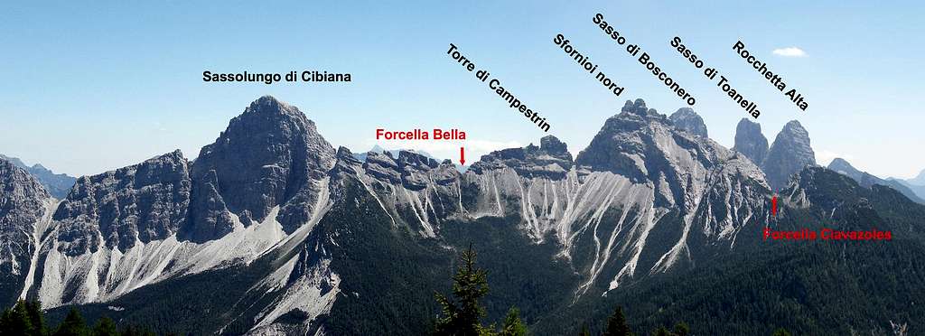
Spigolo Strobel (Rocchetta Alta di Bosconero NW ridge)
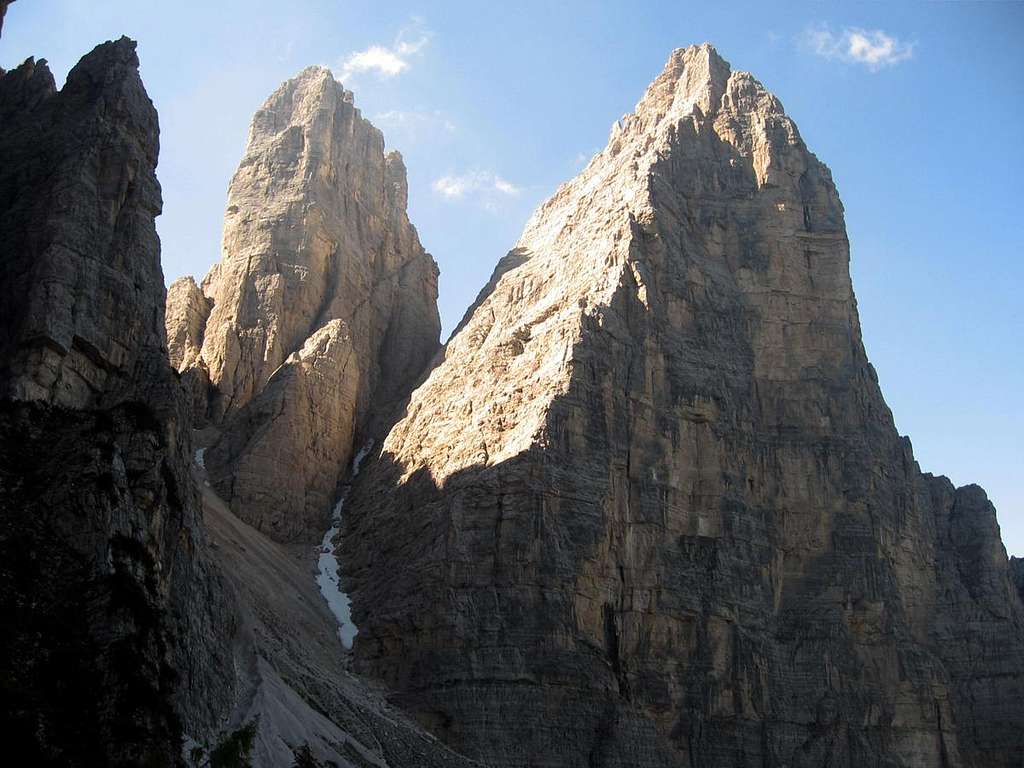
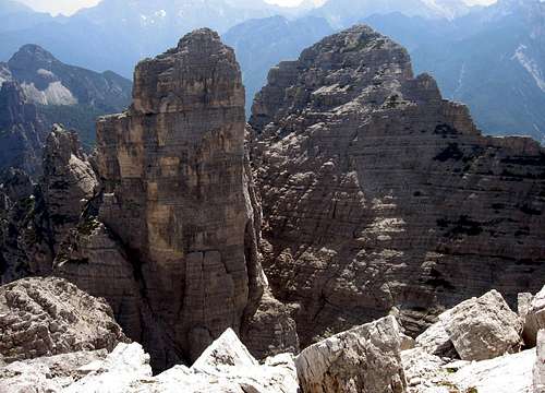
Rocchetta Alta di Bosconero, or simply Rocchetta Alta, is the fifth summit in height of the "Bosconero group", belonging to the Dolomiti di Zoldo. With the neighbour “Sasso di Bosconero" it has the most impressive wall facing the Val di Zoldo side (West). It's part and the major of a cluster of peaks called "Rocchette di Bosconero". Most of the climbing routes are located on the West side above the Zoldo valley.
Despite the altitude of the summit not very high - 2412 m - the walls have the lenght of 650/700m drop! It appears on the West side, from far, like a square rocky wall. If seen from its foot, it has the shape of a huge pyramid even more massive than from other points of view. If seen from East, it’s hidden from the “Sasso di Toanella". The two peaks are divided by a narrow couloir usually covered of snow called “Canalone di Rocchetta Alta”.
The Northern pillar of the Rocchetta Alta di Bosconero is today one of the most admired rocky structures in the Dolomites. The route "Spigolo Strobel", dedicated to Albino Michielli "Strobel", is wonderful, both for the exposure and the continuity of the climbing and for the line, running on the right of the mighty NE pillar.
History
The beauty of the Rocchetta attracted the climbers only from the mid-Sixties, when the Scoiattoli di Cortina (Bruno Menardi - Lorenzo e Sergio Lorenzi - Luciano Da Pozzo - Giusto Zardini) realized this daring climbing itinerary in the year 1964, july 14-15.
Second ascent: Hans-Peter Geihs - Richard Goedeke 1965, July 23th
First winter ascent: Renato Casarotto - Piero Radin - Diego Campi 1974, March
First solo climb: Soro Dorotei 1982, August 12 nd
Getting There
Road access
Rocchetta Alta di Bosconero is located inside the “Bosconero Group", Valle Zoldana. The access is from the town of Longarone. From Longarone reach the Val Zoldana, from there follow the road to Forno di Zoldo. Leave your car in a large car park on the left immediately after the Pontesei lake (signpost on the right indicating the Casera Bosconero).
Walking approach
From the parking lot take the path reaching the nice Rifugio Bosconero (about 1h and 30 min.). To take it easy is advisable stay overnight at the hut.From the refuge follow the path that leads to the Forcella di Toanella up to the edge of the woods. Leave the main and follow to the right a path (cairns) continuing in the direction of the North-West pillar. The start of the route at the bottom of the pedestal is shortly reached across scree terrain (45 minutes from the refuge).
Route Description
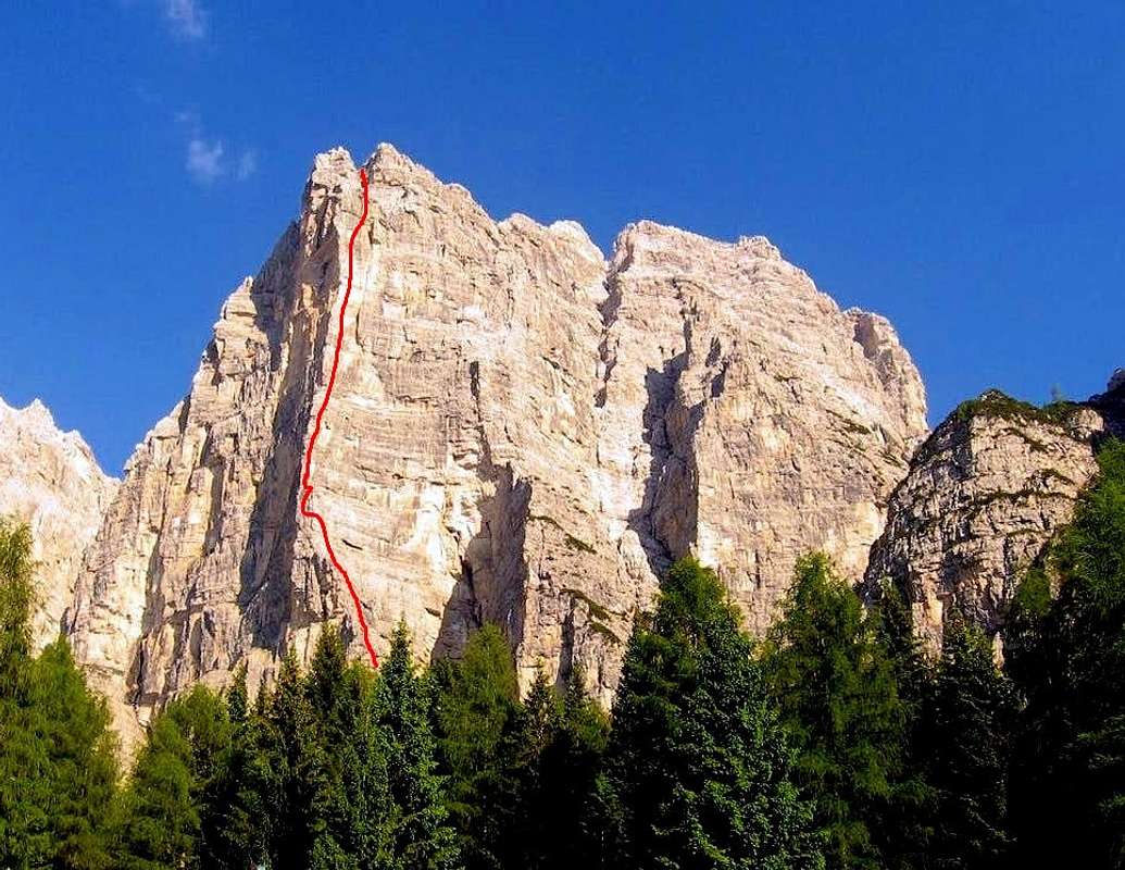
Spigolo Strobel report - UIAA SCALE
Summit altitude: m. 2992
Climbing length: 700 m
Equipment: the pegs at belays are on site, as well as some pegs along the pitches, needed quick protections to integrate
Exposure: West
First ascent: L. Da Pozzo, L. Lorenzi, S. Lorenzi, B. Menardi, G. Zardini 1964, July 14-15
Starting point: Casera Bosconero
A challenging climb on a wonderful line, not to be missed! The route doesn't follow the steep and sometimes overhanging ridge of the Rocchetta, but it follows a direct and very obvious line along dihedrals and cracks.The equipment of the route is good both along the pitches and at the stops, moreover the possibility of integrating with mobile protections is excellent.
Approach
From the refuge follow the path leading to the Forcella di Toanella up to the edge of the woods. At the end of the wood leave this path and head in the direction of the north-west ridge on a trail on stony ground (cairns). The start of the route is reached in about 45 minutes from the refuge and is located near a wide couloir, just to the right of the NW ridge.
Route report
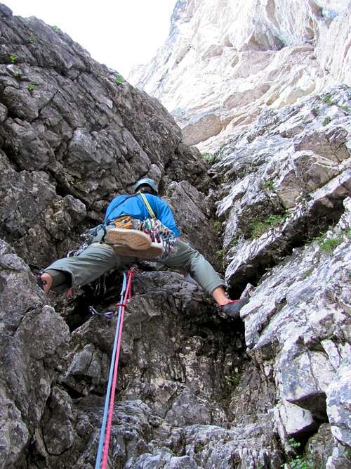
L1 - L2 Climb up the basal pedestal following a series of chimneys from left to right (II, III, III +). Continue to follow the chimney in the direction of an obvious blackish dihedral and stop in a niche at the base of the actual wall (II).
L3 - Climb the roof on the right, then for rocks with more holds, reach the base of the black dihedral and climb it completely, first on the right face, then on the bottom crack, reaching a wide ledge, VI-, then V, 50 m
L4 - Follow the ledge to the left and belay near the ridge, 40 m
L4 - Follow the ledge to the left and belay near the ridge, 40 m
L5 - On easy rocks reach a small terrace under a band of vertical rocks carved by cracks. Climb up under a roof and traverse 2 m to the right, then through cracks overcome a vertical wall to stop on a narrow ledge under an overhang, V, V +, VI, 50 m
L6 - Traverse left towards the ridge at the base of a crack and climb it, then exit right on slabs, return to the the crack and more easily reach a ledge under a roof, V +, VI-, 35 m
L7 - Traverse to the left a few meters under the roof, passing it where it is more affordable, then diagonally to the right towards a yellow black plate. Traverse to the right. and reach the base of a dihedral. Climb the beautiful dihedral with several nails and possibly stop in the middle. VI, VI +, VII-, 35 m.
L8 - Continue along the dihedral which widens as a chimney and stop on a small terrace at the end, V +, 15 m
L9 - Reach the ledge above and go under a roof. Climb it on the left, then traverse right towards a difficult crack, climb it and at the end exit right on a good terrace under a yellow corner, V, VI, VI +, 35 m.
L10 - Difficult pitch. Climb the entire dihedral, passing a roof and after an overhang and gaining a belay at the base of another dihedral, VI, VI +, VII or A0, 35 m
L11 - Follow the corner and after a few meters exit right at a pulpit. Then enter another dihedral of yellow rock and climb it using the bottom crack, reaching a small niche under a yellow dihedral-chimney closed by a roof, V +, VI, 35 m
L12 - Enter the dihedral-chimney and climb it entirely up to the roof closing it, avoiding it on the right and exiting on an exposed terrace at the base of a crack, VI +, p. VII- or A0, 25 m
L13 - Climb the narrow crack, then wider, pass a small overhang and exit by traversing left for a few meters. Reach a small terrace at the base of a crack on the left of a large chimney closed by roofs, VI, V +, 25 m
L14 - Follow the crack and before a roof traverse to the left bypassing an edge. A comfortable ledge is gained climbing on gray rock. Stop in a niche, V, V +, VI, 35 m.
L15 - Exit the niche and enter an open dihedral. Go up the dihedral and under a large roof closing it, exit to the left and on easier rocks reach a large terrace, IV+, V, 45 m. Here the major difficulties end.
Slanting right reach the bottom of two gullies. Take the one on the right which ends at a notch on the summit crest, (II,III, 120 m). Follow the crest to the summit of the North pillar.
Descent: take a small ledge on the right towards the Sasso di Toanella. Descend by ledges interspersed with rock walls and mountain pines (little men), on sometimes exposed terrain. You pass a fixed vertical section (fixed rope), then continue along the ledge to the right until it ends in the channel between Rocchetta Alta and Sasso di Toanella. The canal is often cluttered with snow until late into the season and can be very insidious. You descend it passing some jumps with abseiling up to where it ends in a large scree. For traces of the path you reach the path to the Toanella fork and the refuge
Essential Gear
In addition to the normal mountaineering gear, bring a hammer and an assortment of pegs, stoppers and friends
Red Tape
No permits, no fees and no particulary restrictions in hiking and climbing, but the whole area had been acknowledged inside the Unesco World Heritage natural sites list and requires the best care and respect. More info about Dolomites Unesco World Heritage on SP: Dolomites, living mountains by Silvia Mazzani .
Hut
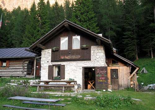
Casera di Bosconero 1457m
Property: CAI sez. Valzoldana
Keeper: Monica Bagatin tel. +393383713870
Size: 28 persons + 4 (winter shelter)
Open from: 20/06 - 20/09
Phone: +39 0437 78100
Access: from lake of Pontesei 858 m, path 485, 2 hours E From Passo Cibiana, path 485, 2 hours EE
When to climb
The best period goes from middle June to middle September
Meteo
ARPAV DOLOMITI METEO Phone +390436780007 fax +390436780008 CENTRO VALANGHE DI ARABBA Phone +390436755711 fax 043679319 e-mail cva@arpa.veneto.it
Guidebooks and maps


"IV Grado Dolomiti Orientali 2" - II edition - Emiliano Zorzi, Luca Brigo, Carlo Piovan - Idea montagna ed. 2018
123 classic and moderne in the groups: Civetta, Moiazza, Fanis, Tofane, Nuvolau, Croda da Lago, Cristallo, Pelmo, Dolomiti Zoldane, Schiara, Antelao, Marmarole
"Pelmo e Dolomiti di Zoldo" - Guida dei Monti d'Italia - G.Angelini & P.Sommavilla - 1983
"Il Bosconero" - Tamari edizioni montagna - De Zordo Vittorio
"La Val di Zoldo" - Cierre edizioni - Bonetti Paolo/Lazzarin Paolo - 2009
Map Tabacco 25 - Dolomiti di Zoldo - Cadorine - Agordine
External links
www.infodolomiti.it zoldoalto@infodolomiti.it