
-
 33795 Hits
-
 79.78% Score
-
 11 Votes
|
|
Area/Range |
|---|---|
|
|
37.56660°N / 90.7333°W |
|
|
Overview
The St. Francois Mountains of southeastern Missouri contains some of the oldest exposed igneous rock in the United States. These rounded mountains, which include the Missouri state highpoint Taum Sauk Mountain, are all that is left of a range that was formed by igneous activity occuring over a billion years ago.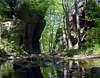 Devil's Tollgate
The St. Francois Mountains are part of the larger Ozark Plateau which includes south and central Missouri, northern Arkansas and small parts of Kansas and Oklahoma and is generally bound by the Missouri and Arkansas Rivers.
The area is drained primarily by the St. Francis River and it's tributaries south into
Arkansas and after about 470 miles empties into the Mississippi River.
A beautiful way to experience the heart of the St. Francois Mountains is to hike a portion or backpack all of the 33 mile Taum Sauk Section of the Ozark Trail. This portion of the Ozark Trail starts at a trailhead on Highway A just west of Bell Mountain and terminates at a trailhead on Highway 21 to the east of Taum Sauk Mountain.
More overview information is available at this site.
Peaks on Summit Post
 Taum Sauk
Taum Sauk Mountain at 1,772 feet is the highest point of the St. Francois Mountains
and the State of Missouri. The standard route begins at the Taum Sauk Mountain
State Park parking lot and follows a paved path. For the more adventurous the
surrounding area is much more interesting including Mina Sauk Falls (the highest
falls in Missouri), Devils Tollgate and the Taum Sauk section of the Ozark Trail.
 Bell
BellBell Mountain at 1,702 feet is the highest point in the Bell Mountain Wilderness
and provides a great overnight campsite for stargazing as the summit has some
great camping areas and is miles from light pollution.
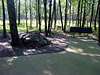
 Mudlick
Mudlick Mountain at 1,313 feet is the highest point in Sam A. Baker State Park
and may be the most prominent peak in Missouri. It also provides the most elevation
gain in Missouri from base to summit. Three stone shelters along the trail to the
summit each make for a great overnighter.
Noteworthy Peaks not yet on Summit Post
Wildcat Mountain 1,770*Buford Mountain 1,740*
Proffit Mountain 1,700*
Lindsey Mountain 1,662
High Top Mountain 1,590
Goggins Mountain 1,484
Pilot Knob 1,470
Hughes Mountain 1,210*
*Peaks I have summited but don't have enough good pictures to post. If someone is willing to submit some good photos for these peaks I would be happy to create pages based on my summit experience.
Shut-Ins of the St. Francois Region
The following bites are excerpted from "Geologic Wonders and Curiosities of Missouri" by the Missouri Department of Natural Resources:"As typically used in the Missouri Ozarks, a "shut-in" refers to a gorge cut by a stream whose valley is locally constricted as it cuts through or between resistant igneous knobs. Upstream and downstream from the shut-in the stream commonly has a relatively wide or open valley and, in some cases, the stream seems to be preverse as it elects to cut a canyon through an isolated mass of igneous rock instead of going around it as a sensible stream would."
"A majority of the Missouri shut-ins are in the St. Francois Mountains area of Washington, St. Francois, Madison and Wayne Counties, with Ironton and Arcadia near the center. Another important area lies east of Eminence."
The following shut-ins are some of the better ones that I have visited:
Big Creek shut-in is actually comprised of three closely spaced shut-ins. Two on Big Creek and one on a tributary to the south between Green Mountain and Stone Battery. These are located near the northwest corner of Sam A. Baker State Park just northwest of Mudlick Mountain.
Hahns Mill (Castor River) shut-in is located in Mark Twain National Forest east of Fredericktown and is one of the best swimming holes in Missouri. Luckily it has remained mostly undiscovered to the masses from St. Louis who flock to the more famous Johnson shut-ins at Johnson Shut-ins State Park.
Crane shut-in is located below the dam at Crane Lake in Mark Twain National Forest about twelve miles southeast of Taum Sauk Mountain.
Johnson shut-in is located in Johnson Shut-in State Park and is a very popular swimming location on summer weekends - in fact the park typically has a line of cars waiting to enter by late morning as the park has an occupany limit that is strictly enforced. Portions of the park were damaged by the colossal failure of the Taum Sauk Reservoir in December of 2005. Check the Park website for the status of accessibility. Photos of the damage can be seen here. The Park Ranger and his family barely escaped with their lives - if this failure had occured in the summer season there could have been hundreds of people swimming at the shut-ins in the path of this flood.
 Mill Mountain
Mill Mountain shut-in on Rocky Creek in Mark Twain National Forest and is located
along the Ozark Trail and is one of the best backcountry swimming holes around.
Klepzig Mill, a abondoned mill built in the early 1900's, is located along Mill
Mountain shut-in. To access Mill Mountain shut-in from Highway NN via the Ozark
Trail you will pass through Buzzard Mountain shut-in as well.
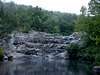 Rocky Falls
Rocky Falls shut-in is located in Mark Twain National Forest near the Current River
on a spur of the Ozark Trail and is a spectacular sight where Rocky Creek tumbles
40 feet down a steep slope of pink and purple porphyry into a large pool (ideal for
swimming - are you beginning to notice a theme in this section?).
Royal Gorge is located just east of Taum Sauk Mountain along Highway 21. There is a pull-out along the east side of the highway from which the shut-in can be viewed.
Shut-In Creek is located between Bell Mountain and Lindsay Mountain in Mark Twain National Forest. It is accessible by bushwacking down the east slope of Bell Mountain to the creek 600 feet below. This bushwack can try your endurance as the Bell Mountain summit is a long hike by itself.
Silver Mine shut-in is located in Mark Twain National Forest on the St. Francis river just downstream from Tiemann shut-in and Mud Creek shut-in. These three shut-ins provide the best whitewater in Missouri after a nice rain.
Tiemann (Millstream Gardens) shut-in is on the St. Francis River east of Acadia Valley and is an especially scenic shut-in. The stretch of the St. Francis River between Tiemann shut-in and Silver Mine shut-in in Mark Twain National Forest is the best white water stretch in Missouri and is frequently ran by kayakers in the spring.
If anyone has any good photos of these shut-ins please feel free to add them to this page. Good submissions will be considered for inclusion in this section.