
-
 8261 Hits
-
 73.06% Score
-
 3 Votes
|
|
Trailhead |
|---|---|
|
|
37.57030°N / 90.7279°W |
|
|
Iron |
|
|
1760 ft / 536 m |
Getting There
Head south on State Route 21 from Arcadia, Missouri for about 4 and a half miles. Turn right onto Highway CC which is signed for Taum Sauk Mountain State Park. Along Highway CC you will see an Adopt-A-Highway sign listing the highpointers club and it's founder Jack Longacre who lived in this area. After a few miles the pavement will end near a fork in the road. To the left is a lookout tower with wonderful views, to the right is Taum Sauk Mountain State Park. Once in the park there will be a viewing platform on the right side of the road that includes a panoramic photo labeling the peaks and valleys before you. At the end of the road is parking for many vehicles. I've seen as many as five different state plates - apparently highpointers - at one time.Destinations from this Trailhead
Photos of a few Destinations
Description of Destinations
Taum Sauk Mountain summit - Missouri state highpoint
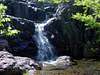
Mina Sauk Falls - highest waterfall in Missouri located on the southwest slopes of Taum Sauk Mountain
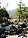
Wildcat Mountain - second highest point in Missouri (bushwack)
Devil's wall - Rocky wall on the west and south slopes of Wildcat Mountain (bushwack)
Devil's Tollgate - nice rock formation through which the Ozark Trail passes
Unnamed waterfall (about a ten feet drop - location is approximate) on the west slopes of Taum Sauk Mountain (bushwack)
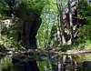
Unnamed scenic shut-in (location is approximate) on the west slopes of Taum Sauk Mountain (bushwack)
Proffit Mountain via the Ozark Trail
The beautiful shut-ins of Johnson Shut-Ins State Park via the Ozark Trail