
-
 10568 Hits
-
 81.18% Score
-
 13 Votes
|
|
Area/Range |
|---|---|
|
|
50.39651°N / 115.78421°W |
|
|
Hiking, Scrambling, Skiing |
|
|
Summer, Fall, Winter |
|
|
8816 ft / 2687 m |
|
|
Overview
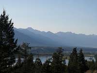 View south to Stanford Range
The Stanford Range is a subrange of the Canadian Rockies, located along the eastern side of the Rocky Mountain Trench in South-Eastern British Columbia. The main parent range is referred to as the Southern Continental Range, further divided down into three main subdivisions; the Front Ranges, the Main Range (sometimes referred to as the Park Ranges) and the Kootenay Ranges (sometimes referred to as the Western Ranges). The Kootenay Ranges include the Beaverfoot Range, the Brisco Range, the Hughes Range, the Van Nostrand Range and the Stanford Range.
 Map of Stanford Range
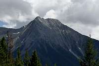
The highest point in the Stanford Range is the summit of Indian Head Mountain at 2687 metres (8815 feet). The boundary of range is defined by the valley bottoms of the significant drainage basins. Specifically, south of Sinclair Creek and Canyon, west of the Kootenay River and east of the Columbia River and its continuous lakes, Columbia Lake and Windermere Lake. The range has fairly low elevation summits with prominent highpoints reaching over 2400 metres (8000 feet) with an average tree line elevation of 2100 metres (7000 feet); the somewhat deep valley bottom elevations (lowest about 810 metres, 2660 feet) can require a lot of elevation gain to reach a summit.
The valley along the western edge of the Stanford Range is the source of the Columbia River. The name of Columbia River is first applied to the outlet stream emerging from the northern end of Columbia Lake. The Columbia River is 2000 kilometres (1,243 miles) in length and flows north from Columbia Lake towards Golden, British Columbia eventually reaching the Pacific Ocean on the Oregon coast.

|
 |
 |
|---|
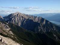
There are no glaciers in the range and no published information on alpine rock routes. The range provides scenic hiking and interesting rock scrambles. The region receives significant snowfall in the winter, but nothing is documented about ski routes or descent lines. The only sport crag developed is on Mount Sabrine above the town of Canal Flats; including an old school trad rock route established by Canadian climbing pioneers Pat Morrow and Bernhard Ehmann in 1977. Once a website address www.mountainelectric.ca provided some great route topo's and history regarding routes on Mt. Sabrine, but unfortunately in 2014 this website went offline.

The range was named by John Palliser in 1863 for Edward Stanford, a London map publisher. The Stanford firm still publishes maps and remains one of the most important and prolific cartographic publishers in the world.
Geology
The Rocky Mountain Trench was created mainly by Cenozoic-aged extension faulting. The extensional faulting was substantial, having extended as deep as 13.5 km (8.4 mi). The southern trench also differs from the northern trench in that it is more sinuous and is asymmetrical in cross-section (perpendicular to its length). The western side of the Southern Rocky Mountain Trench is more subdued and irregular than the east side. During late Paleozoic to Mesozoci rapid sediment deposition and subsidence to the west transitioned in the area of the modern Rocky Mountain Trench into a stable continental shelf in the east. The Nevadan Orogeny destroyed the western wedge of sedimentary rocks during Jurassic to middle Cretaceous time, thrusting them up into metamorphic fold belts. Currently, strata on either side of the Southern Rocky Mountain Trench consist mainly of Precambrian and Paleozoic sedimentary rocks.History
The entirety of the range would have been covered by glacial ice during the last ice age, likely completely covering the summits, with valley bottoms holding ice until 10,000 years ago. The local aboriginal people, the Ktunaxa (Kootenays), hunted and lived in valleys of the Stanford Range as the glaciers retreated more and more. In 1807 the first European explorer arrived. David Thompson, aided by Ktunaxa guides, canoed the North Saskatchewan River to Howse Pass, then followed the Columbia River south to its headwaters.Also in 1807 Thompson built a fort, Kootenae House, near present day Invermere. At that time the Columbia Valley was primary dry grassland, with both natural grass fires, and fires started by the Ktunaxa, cycling the regrowth of the grass. Eventually fire control and farming allowed the cooler coniferous forest to descend to the valley bottom. Throughout the 1800’s gold, farming and logging brought more and more Europeans to the region. Today, the once dominant logging and mining industries are secondary to tourism and recreational support industries.
Getting There
The Stanford Range is surrounded by roads. Two primary highways, highway 93 along the northern edge in Kootenay National Park, and highway 93/95 in the Columbia Valley provide access to the region. Highway 93 connects to the Banff National Park and the Trans Canada Highway with Canmore about 170 kilometres from the northern Columbia Valley town of Invermere. Calgary is about 270 kilometres from Invermere.
The most popular hiking and scramble routes in the range get access from FSR’s (Windermere Creek and Madias Creek) leaving highway 93/95 travelling east to the western side of the range. This includes access to Mt. Aeneas, Swansea Mountain, Indian Head Mountain, Mt. Tegart and associated hikes and outlier peaks. The eastern edge FSR’s are well maintained, but only ploughed in the winter if there is winter mining or logging occurring; this varies winter to winter.
Red Tape
Essentially there is none. The majority of the Stanford Range is B.C. Crown Land. Within Canada, Crown Land is a designated area belonging to the Queen in Right of Canada, the equivalent of an entailed estate that passes with the monarchy and cannot be alienated from it; thus, per constitutional convention, these lands cannot be unilaterally sold by the monarch, instead passing on to the next king or queen unless the sovereign is advised otherwise by the ministers of the Crown. Though the Canadian monarch owns all Crown Land in the country, paralleling the division of the Crown amongst the federal and provincial governments, Crown Land is similarly divided so that some lands within the province are administered by the provincial Crown, whereas others are under the federal Crown.In British Columbia, like all provinces, Crown Land is extensively leased for resource extraction, typically mining and logging. There are many active mine sites and ongoing logging in the Stanford Range; this industry active is obvious and well posted and likely causes little impact (other than visible) on the recreationalist. There are three minor Provincial Parks (Dry Gulch, Columbia Lake and Canal Flats) and provincially protect ecological reverses, but there sites are small, mostly provide camping or limit access for ecological protection, and have no impact on access to alpine terrain.
Crown Land is generally available for camping anywhere, unless leased to a specific party for resource development, farming or ranching. Any leased area are generally signed as such. No fee or registration required for parking, camping or climbing. Wear bright clothes during hunting season!
List of Peaks

The range contains 15 officially named summits and approximately 10 unofficially named significant summits. Local, unofficial names for features are shown italicized within quotes after the Universal Transverse Mercator (UTM) National Topographic System of Canada (NTS) grid reference, denoted as GR.
Principle Summits
|
Indian Head Mountain 2687 metres (8,850 ft.). Official Name. |
 |
 |
|---|---|---|
|
Mount Aeneas 2675 metres (8,776 ft.) Official Name. |
 |
|
|
Mount Sinclair 2667 metres (8,750 ft.) Official Name. |
||
|
Fairmont Ridge 2650 metres (8,694 ft.) Official Name. |
 |
 |
|
Fairmont Mountain 2628 metres (8,622 ft.) Official Name. |
 |
|
|
Pinto Mountain 2547 metres (8,450 ft.) Official Name. |
||
|
Mount Pedley 2545 metres (8,350 ft.) Official Name. |
 |
|
|
Mount Bryan 2490 metres (8,169 ft.) Official Name. |
||
|
Nappe Mountain 2451 metres (8,041 ft.) Official Name. |
||
|
Mount Tegart 2393 metres (7,850 ft.) Official Name. |
 |
Redstreak Mountain 2160 metres (7,085 ft.) Official Name. |
|
Mount de Smet 2157 metres (7,077 ft.) Official Name. |
||
|
Four Points Mountain 1905 metres (6,250 ft.) Official Name. |
||
|
Swansea Mountain 1735 metres (5,692 ft.) Official Name. |
||
|
Mount Sabine 1603 metres (5,259 ft.) Official Name. |
Secondary Summits
|
GR 871856 2667 metres (8,750 ft.) Unofficial Name. (50:25:06 | -115:46:34) |
 |
|---|---|
|
GR 818015 'Piebald Peak' 2637 metres (8,652 ft.) Unofficial Name. (50:33:24 | -115:50:42) |
|
|
GR 856876 2599 metres (8,527 ft.) Unofficial Name. (50:26:05 | -115:45:00) |
|
|
GR 778061 'Dappled Peak' 2590 metres (8,500 ft.) Unofficial Name. (50:36:08 | -115:54:01) north portal of Kimpton Pass |
|
|
GR 825995 2575 metres (8,450 ft.) Unofficial Name. (50.5412 | -115.836400) |
|
|
GR 776047 2537 metres (8,323 ft.) Unofficial Name. (50:35:23 | -115:55:04) south portal of Kimpton Pass |
|
|
GR 885964 2500 metres (8,200 ft.) Unofficial Name. (50.51219 | -115.79472) |
|
|
GR 751059 2481 metres (8,140 ft.) Unofficial Name. (50:36:02 | -115:56:18) |
|
|
GR 868704 2347 metres (7,700 ft.) Unofficial Name. (50.2811599 | -115.782160) |
|
|
GR 846826 2339 metres (7,674 ft.) Unofficial Name. (50:23:28 | -115:48:36) |