
-
 16412 Hits
-
 91.75% Score
-
 36 Votes
|
|
Area/Range |
|---|---|
|
|
50.76650°N / 115.095°W |
|
|
Hiking, Mountaineering, Ice Climbing, Mixed, Scrambling |
|
|
Summer, Winter |
|
|
10161 ft / 3097 m |
|
|
This page is still a work in progress and will be updated and upgraded over the next several years. More peaks in this range will be added as children over time.
 |
 |
 |
|---|
Overview
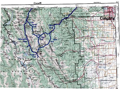
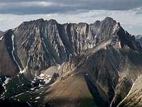
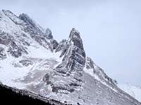
The Opal Range is a compact subrange of the Canadian Rockies, located west of Calgary in Kananaskis Country, near the continental divide, with an approximate surface area (flat map area) of 185.0 square kilometres (70 square miles). The main parent range is referred to as the Southern Continental Range, further divided down to the Front Ranges, though not really on the Front. The broader term of Kananaskis Ranges refers to a grouping of 3 ranges; the Opal Range, the Fisher Range and the Kananaskis Range.
 |
The highest point in the Opal Range is the summit of Mount Evan-Thomas at 3097 metres (10,161 feet). The boundary of range is defined by the valley bottoms of the significant drainage basins. Specifically, east of the Kananaskis River/Pocaterra Creek, south and west of Evan-Thomas Creek, west of the Little Elbow River and north of a small section of the Elbow River and Elbow Lake. These principle watercourses flow from several primary passes; Tombstone Pass (2270m), Evan-Thomas Pass (2180m) and Elbow Pass (2085m). |
|---|
 Opal Range location
Geology and Human History
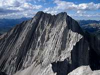
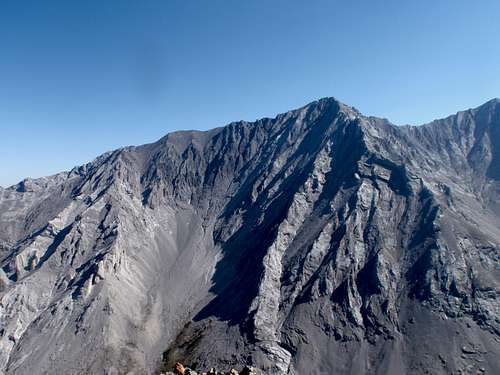
A period that occurred during the Lewis Thrust called the Laramide Orogeny created the Opal Range. The Opal Range is composed of sedimentary limestone, primary the Rundle Formation, with near vertically tilted sedimentary layers providing sharp, sawtooth profiles, deep gullies and steep slab faces. Localized intrusions of conglomerate dolomites and metamorphic quartzite help add colour against the light grey of the dominate limestone. These intrusions at appear at lower elevations and provide dramatic contrast to bright green meadows and sparking creeks. The entirety of the range would have been covered by glacial ice during the last ice age; valley bottoms likely held ice until 10,000 years ago. The local aboriginal people certainly hunted and lived in valleys of the Opal Range during the summer months. The dramatic landscape with many inspirational features must have influenced local spirit mythology. European explorers began expeditions in the within the current boundary of Alberta in 1754 by Anthony Henday, but the local Kananaskis River valley first saw Europeans in 1860’s, at that time the region was dominated by the Niitsitapi (Blackfoot Nation). George Dawson named the Opal Range when he discovered small cavities lined with quartz and coated with what he thought were thin films of opal. However, it was not opal, but a chert with a similar appearance composed of silica imbedded with various quartz impurities.
 |
 |
 |
|---|
Exploitation of natural resources began soon after the arrival of the settlers and continued unabated with lumber, coal mining, oil and gas exploration until the early 1970’s. Once the prime resources were consumed, or harnessed by dams, and since carbon based resources were minimal, the continued growth in population in the region made the area more ideal for recreational purposes. In 1977 Peter Lougheed Provincial Park (originally named Kananaskis Provincial Park), and the surrounding multi-use area, Kananaskis Country were established to develop recreational facilities in the region.
Climbing History
Once access was better developed, and more people had time to climb, the major summits were soon conquered. First ascents began in 1950’s, with a surge by Glen Boles and Don Forest during the 1960’s and 1970’s. The focus of climbers was alpine climbing with attaining summits as the primary goal. Despite the verticality, easy access and pockets of good quality rock, no sport crags or multi pitch rock routes (non summit routes) have been developed in the range. Primary waterfall ice climbs were completed as the sport developed, with the top-drawer ice route in the range, Whiteman Falls, climbed in 1979. Apart from this classic route, only minor ice climbs exist; with a two exceptions, the Evan-Thomas Creek drainage has excellent short ice routes and a new bolted mixed venue, Rehab Wall and modern mixed routes in the Opal Creek/Whiteman Falls area. The range is mostly in a rain shadow of the continental divide and only occasionally provides good snow for touring or turns. High winds in the winter are common and rake most of the ridges and basins bare of snow above tree line.
Getting There
Easy highway access from Highway 40 along the western edge of the range provides the best approach. Highway 40 does provide access from the Trans Canada Highway in the north, and continues south to the Longview area, but the southern section is closed for wildlife protection from December 1 to June 15 each winter/spring. Best vehicle access from Canmore/Banff or Calgary is via the Trans Canada Highway, south along Highway 40.
 |
 |
 |
 |
|---|
Red Tape
About half of the Opal Range is located in Peter Lougheed Provincial Park and the other in the Elbow-Sheep Wildland Provincial Park, with the high point of range forming much of this boundary. Best highway access from Highway 40 (Peter Lougheed Provincial Park ) or long bike or boot approach from Highway 66 (Elbow-Sheep Wildland Provincial Park). Peter Lougheed Provincial Park only allows backcountry camping in designated backcountry campgrounds and no random backcountry camping is allowed. Backcountry camping permits are required at all designated backcountry campgrounds anywhere in Kananaskis Country. Random backcountry camping without a permit is allowed in most Wildland Provincial Parks, including Elbow-Sheep Wildland Provincial Park. Permits can be purchased in person at Barrier Lake Visitor Information Centre and the Peter Lougheed Provincial Park Visitor Information Centre during normal hours of operation. No permit is required to climb in these parks. Up to date information is available at Alberta Parks.
Important Red Tape Update. As of June 2021, a mandatory user fee will be in place for Kananaskis Country - 90$ for an annual pass or 15$ for a day pass. More information: https://www.alberta.ca/kananaskis-conservation-pass.aspx
List of Peaks
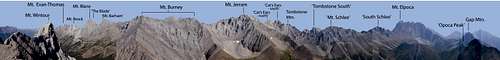
The range contains 15 officially named summits and approximately 20 unofficial summits, including several striking stand alone outliers or features that provide interesting climbs. In the lists below, unofficial names for features are shown italicized within quotes after the Universal Transverse Mercator (UTM) National Topographic System of Canada (NTS) grid reference, denoted as GR.
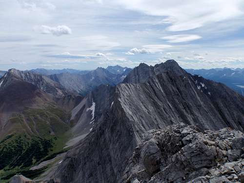
The Opal Range provides a stunning silhouette from Evan-Thomas Creek south to Elbow Pass. However, the primary section of the range is the stunning ridge line formed from Mt. Evan-Thomas south to Mt. Elpoca. This is highest elevation section of the range, the heart of the range, and provides the most interesting climbs. Outliers of this grouping complete the range with lower elevation summits and peaks, but a few higher peaks protrude.
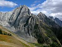
 Main Range of the Opals - West side
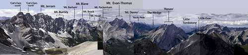 Main Range of the Opals – East side
Principle Summits
| Mount Evan-Thomas
3097 metres (10,161 ft.) Official Name. First ascent July 1954 by M. Dixon, N. Gish, S. Pearson and P. Rainier via North-West Ridge. |
 |
 |
| GR 373253 (’Ripsaw' or 'Mt. Sarcee’)
3008 metres (9,868 ft.) Unofficial Name. First ascent September 1976 by D. Forest and J. Calvert via East Face to North-East Ridge. |
 |
 |
| GR 338277 (’Mt. Potts’)
3000 metres (9,843 ft.) Unofficial Name. First ascent July 1954 by J. Farman, M. Hicks, W. Lemmon, G. Ross, I. Spreat and J. Tarrant via South-East Ridge. |
 |
 |
| GR 338277 (’Mt. Denny’)
3000 metres (9,843 ft.) Unofficial Name. First ascent March 1973 by J. Martin solo via South-West Face. |
 |
 |
| Mount Packenham
3000 metres (9,843 ft.) Official Name. First ascent June 1972 by J. Pomeroy, M. Simpson and D. Forrest and G. Boles via North-West Face, North Ridge |
 |
 |
| Mount Hood
2903 metres (9,524 ft.) Official Name. First ascent May 1953 by J. Dodds, W. Lemmon and others via North Ridge from Hood/Packenham col. |
 |
 |
| Mount Brock
2902 metres (9,521 ft.) Official Name. First ascent July 1954 by P. Duffy and K. Ingold via South-West Face. |
 |
 |
| Mount Blane
2993 metres (9,820 ft.) Official Name. First ascent September 1955 by P. Duffy, G. Johnson, D. Kennedy and F. Koch via Blane/Brock col and chimneys of West Face. Koch was killed by rock fall during descent. |
 |
 |
| Mount Burney
2934 metres (9,626 ft.) Official Name. First ascent August 1956 by R. Lofthouse solo via West Face. |
 |
 |
| Mount Jerram
2996 metres (9,829 ft.) Official Name. First ascent June 1957 by D. Morrison and J. Tarrant via West Ridge. |
 |
 |
| Tombstone Mountain
3029 metres (9,938 ft.) Official Name. First ascent September 1975 by E. Grassman and others via West Ridge and North Ridge. |
 |
 |
| GR 407165 (’Tombstone South’)
3000 metres (9,843 ft.) Unofficial Name. First recorded ascent August 1969 by M. Bowen, K. Smith and J. Martin via South-East Face; cairn on summit, but no record. |
 |
 |
| Elpoca Mountain
3036 metres (9,938 ft.) Official Name. Lower, south summit, first ascent 1960 by D. Elliott, H. Kirby and P. Scribens. Main (North) summit first ascent unknown. |
 |
 |
Secondary Summits
| GR 382180 ('Cat's Ears - north')
2960 metres (9,711 ft.) Unofficial Name. First ascent June 1982 by D. Forest and F. Campbell. |
 |
 |
| GR 385179 ('Cat's Ears - south')
2960 metres (9,711 ft.) Unofficial Name. First ascent Sept. 1981 by D. Forest and G. Fraser. |
 |
 |
| GR 363205 ('Mt. Barham')
2920 metres (9,580 ft.) Unofficial Name. First ascent unknown, but has been climbed. |
 |
 |
| GR 361210 ('The Blade')
2920 metres (9,580 ft.) Unofficial Name. Impressive gendarme on South Ridge of Mt. Blane. First ascent September 1974 by P. Morrow and C. Perry via South Ridge. |
 |
 |
| GR 334290 ('Rocky Peak’)
2915 metres (9,564 ft.) Unofficial Name. First recorded ascent by Kevin Barton and Laurie Kimber, July 2, 2014 by West Gully to West Ridge. |
 |
|
| GR 385168 ('Mt. Schlee’)
2850 metres (9,350 ft.) Unofficial Name. First ascent D. Forest, G. Scruggs, G. Boles and M. Simpson via South Ridge. |
 |
 |
| GR 396213 ('Little Tombstone')
2800 metres (9,186 ft.) Unofficial Name. First ascent July 3, 1975 by S. Toporowskj and D. Smith via North Ridge |
 |
 |
| GR 388157 ('South Schlee')
2800 metres (9,186 ft.) Unofficial Name. First ascent September 18, 2016 by Kevin Barton and Scott M. Berry via North Ridge/West Face |
 |
 |
| Mount Wintour
2700 metres (8,858 ft.) Official Name. First ascent September 1968 by G. Boles and E. Peyer via North Ridge. |
 |
 |
| GR 401140 ('Elpoca Tower')
2680 metres (8,793 ft.) Unofficial Name. First recorded ascent 1998 by O. Miskiw and others via South Buttress. |
 |
 |
| Gap Mountain
2675 metres (8,776 ft.) Official Name. First ascent August 1948 by Hans Schwarz solo. |
 |
 |
| The Wedge
2667 metres (8,750 ft.) Official Name. First recorded ascent 1950 by unknown party via North West Ridge. |
 |
 |
| GR 385256 ('Little Evan')
2665 metres (8,743 ft.) Unofficial Name. First ascent unknown, but has been climbed. |
 |
 |
| Opal Ridge (North)
2575 metres (8,448 ft.) Official Name. First recorded ascent March 1977 by J. Martin solo via South-West Face. |
 |
 |
| Opal Ridge (South)
2575 metres (8,448 ft.) Official Name. First ascent unknown, but has been climbed. |
 |
 |
| GR 328249 ('Grizzly Peak')
2545 metres (8,350 ft.) Unofficial Name. First ascent unknown, but has been climbed many, many times. |
 |
 |
|
2480 metres (8,137 ft.) Unofficial Name. No record of previous ascent. FRA Kevin Barton and Laurie Kimber via East Face and traverse, 5.7+R. June 19, 2018. |
 |
 |
| GR 323350 ('Mt. Mackay')
2455 metres (8,055 ft.) Unofficial Name. First ascent unknown, but has been climbed. |
 |
 |
| GR 333341 ('Mackay Hills - centre')
2440 metres (8,005 ft.) Unofficial Name. First ascent unknown, but has been climbed. |
 |
 |
| GR 374159 ('East Opoca')
2450 metres (8,040 ft.) Unofficial Name. No official record of a first ascent, but would have been easily ascended many years ago. |
 |
 |
| King Creek Ridge
2425 metres (7,956 ft.) Official Name. First ascent unknown, but has been climbed. |
 |
 |
| Limestone Mountain
2173 metres (7,129 ft.) Official Name. First ascent unknown, but has been climbed. |
 |
 |