
-
 7631 Hits
-
 84.27% Score
-
 18 Votes
|
|
Route |
|---|---|
|
|
41.97580°N / 111.6608°W |
|
|
Hiking, Mountaineering |
|
|
Spring, Summer, Fall |
|
|
Most of a day |
|
|
Class 2 |
|
|
Overview
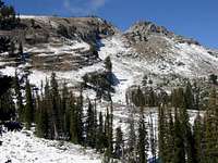 Doubletop Mountain
Steep Hollow is the shortest route to the summit. It is located on the east side of Doubletop Mountain. I enjoyed the route a lot but this may be because everything was covered in snow. This is an interesting mountain that isn't climbed as often as peaks farther south. The route follows an old jeep trail and then branches off into the north fork of Steep Hollow. Either fork of the canyon can be used on the approach. It then climbs up the east face of Doubletop Mountain.
Doubletop Mountain is the second highest peak in the Bear River Range. The summit is near the border of Northern Utah with the north ridge connecting into Southeastern Idaho. The name of the mountain comes from its twin summits. A distinct gunsight notch divides the two summits. The south summit is the highpoint and the north summit has the more interesting summit block. The mountain is not climbed often.
Getting There
Drive on I-15 north of Brigham City and take exit 362 (US-91/Logan). Keep driving on US-91 through Sardine Canyon. After 25 miles US-91 will merge into Main Street in Logan. Drive to the intersection of Main Street and 400 North in Logan. Turn east on Hwy 89 into Logan Canyon. Drive up Logan Canyon for about 25 miles until you see a dirt road branching off to the west signed for Franklin Basin. Drive down this road for about 3.3 miles. There is a dirt road on the left with a sign that will either be labeled as Steep Hollow or Steep Canyon. On maps it is labeled as Steep Hollow so that is what I will call it. High clearance vehicles can drive farther. If the road is wet 4-wheel drive is recommended. The road continues for 1.5 miles. There will be a few side roads but just stay on the main road which ends at a barrier that was put there for ATV riders. The high clearance trailhead starts here.
Route Description
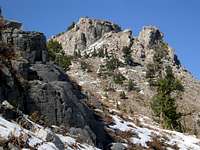 Doubletop Mountain
Approach Option #1 - South Fork / Standard Route
This is the route described in Kelsey's Utah Mountaineering Book. From the parking area follow the old dirt road until you get to the high clearance parking area. Those of you who are lucky enough to have driven to the higher parking area are starting here. Follow the route which goes along a jeep trail. The trail will start heading toward a basin. This is where the jeep trail changes directions to the southwest. Leave the jeep trail and hike toward the low point of the ridge that is south of Point 9,588. Once on the main ridgeline, follow this north. There should be a trail if the ridge is not covered in snow.
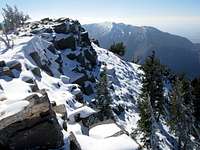 Doubletop Summit
The summit is a flat rocky plateau that is similar to Naomi Peak. It has a nice cliff on its west face. With a name like Doubletop, you have to climb both summits. The north summit requires a little scrambling but is not difficult. The view includes all of the major southern peaks like Gog, Magog, and Naomi Peak. The view north looks into Idaho. You can see Cache Valley and several cities below.
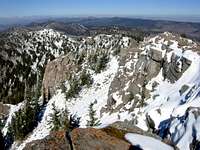 Summit View
Approach Option #2 - North Fork / Direct Route
This is the route I used to climb the mountain. There was a lot of new snow in the mountains and this more direct route seemed a little safer from steep snow cornices on the ridge. The route branches off from the standard route at the large basin at 8,400 feet. Hike cross country in northwest direction. You’ll want to go around the ridge of Point 9,018. Continue into what I call the cirque of upper Steep Hollow. You should be able to see Doubletop through the trees most of the time so route finding is straight forward.
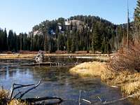 Crescent Lake
Once you make it to the base of the steep east face you have two choices. You can either climb up the slabs to the left of the south summit or climb directly up the notch between the two summits. I chose to climb up the slabs on the left because there was less snow. During summer, climbing up either way will work just fine. Remember that the south summit is the highpoint so you’ll want to head toward that.
Crescent Lake Canyon Descent
This is an optional descent down Crescent Lake Canyon. This is the next canyon north of Steep Hollow. This is for people looking for a fun alternative to the regular descent back down Steep Hollow. From the summit, downclimb to the notch between the two summits. For this route you can continue over to the north summit which is most easily climbed from the south ridge up steep boulders. You can also descend around the north summit and then go towards the north ridge.
Follow the north ridge to the Point 9,652. Now change directions and follow the ridge east to Point 9,645. From this point descend down northeast into Crescent Lake Canyon. The lake will be directly southeast of you. This is a rarely visited lake, located below Point 8,954, so be sure to spend some time there. From the lake, hike over the ridge to the southeast through the forest. You should be able to find the dirt road that you used on the approach so you can't get lost here.
Distance from the lower trailhead to the summit is 5.85 miles and elevation gain is 2,473 feet
When to Climb
This route is best climbed during the summer months. I would say that you could climb from mid-June through mid-October depending on conditions. Use caution during hunting season. There will be hunters in this area during this time.
This route would be difficult to access in winter because dirt roads will be covered in snow. Franklin Basin road is used by snowmobilers and is packed down so you could ski in to the trailhead if you want to. This would add several miles to the route.
Essential Gear
Regular day hiking essentials. Food and water. Good pair of hiking boots. A road map is helpful because of all dirt roads in the area. Also, have a topo map of the mountain with you.