Introduction
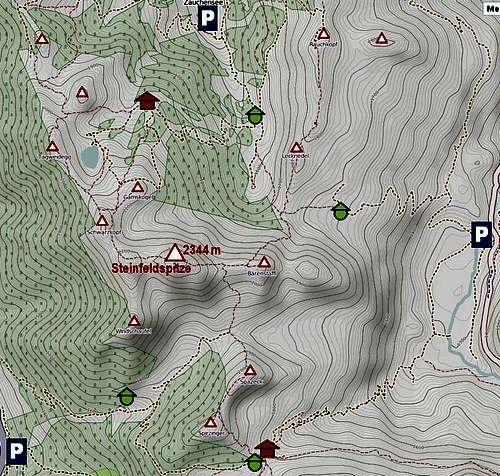
When hiking over highly degraded ski slopes above Zauchensee, one can hardly imagine that above 1900 m of altitude, and especially on the summit ridge, the scenery will change so much. The upper part of this hike is very nice and panoramic.General Information
Views from the ridge Overall difficulty: It's a hiking tour, difficulties are concentrated on the summit ridge. There, parts of trail are protected by cables, but on many places there is no protection and easy climbing (UIAA I) is needed. Rock is brittle and the path is very exposed. On the
Swiss Hiking Scale its difficulty would be graded T4, a place or two perhaps even T5.
Orientation: Easy, all the time marked.
Exposition: Some places are exposed, so a lot of care is needed.
Best season: Dry months of season (June to October).
Gear: Good shoes and poles. Rope for less experienced or children.
Tour start: Zauchensee, 1361 m. See the main page how to get there.
Highest point: 2344 m.
Altitude to overcome: 1000 m.
Time for ascent: 3 h 30 min.
Route Description
Seekarkessel
On the saddle below Gamskogel From the
parking place we follow the inscriptions on plates
towards the W. We gain some 250 m by a road, then we follow ski slopes towards the SW to
Gamskogelhuette, 1878 m. From there we continue towards the SW and soon reach the shore of artificial lake in
Seekarkessel, 1960 m. Ski slopes continue also above it. We follow them
towards the S, where we find a
crossroads. The horizontal route follows the road towards the E, below Gamskogel, while we deter
right and cross a high plateau
towards the S. Nice marked path is winding through the landscape, then it ascends some 50 m on a distinct
saddle between Gamskogel on the left and Schwarzkopf on the right. Nice views open towards the E and towards the SE, on the northern face of Steinfeldspitze.
From the saddle we follow a weak path
towards the right, by the ridge towards Schwarzkopf. But only a few minutes, then the path starts
crossing the E slopes of Schwarzkopf. It is narrow, but without any difficulties we reach in some 15 minutes the
notch in the NW ridge of Steinfeldspitze. Great views towards the SW open!
By the W ridge
Descending the ridge Along the ridge we immediately meet a few sections, where the path is secured by cables. The path is narrow, and some easy climbing is needed. Then the path switches to the other side of the ridge, where it soon goes more steeply up. We scramble by a rocky, crumbly terrain up and soon reach the main ridge again. By it and partly by its northern side we continue towards the E. We pass the W foresummit and gain a
bump in the ridge, where the path can't continue by it any more. The arrow on the rock directs us
steeply down towards the south. The cable lies on the ground and is of little help, unless we want to crawl down. Also continuing over a very steep grassy slope is unpleasant and very exposed. Then a
crossing follows, where the route is not protected, in the grass we see only a few old pegs which probably once held a cable. By a narrow ledge around a rocky edge we reach a shallow ravine, then the path starts to
ascend again. By steep scrambling we finally reach the
summit ridge and by it the
highest point.