
-
 2852 Hits
-
 83.1% Score
-
 16 Votes
|
|
Mountain/Rock |
|---|---|
|
|
47.26623°N / 13.45009°E |
|
|
Hiking, Mountaineering, Scrambling, Via Ferrata, Skiing |
|
|
Spring, Summer, Fall |
|
|
7690 ft / 2344 m |
|
|
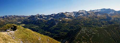
Overview

Steinfeldspitze and its N face from the north-west
Broader Area

Western views
In the eastern branch the first higher summit from the north is Strimskogel, 2139 m. South of it the ridge is lowering over a few unimportant summits (Taxalmkogel, 2021 m, 2038 m, Hakopf, 1996 m), then reaching Schlanningsattel, 1846 m. There one cable car reaches from the valley. The ridge further towards the south is more plateau-like, then it descends to Stubhoehe, 1739 m. That's a broad saddle with a big alpine meadow east of it. South of it, a higher and steeper north face of Baerenstaffl, 2125 m, rises. That is already the first higher summit in the main ridge of Steinfeldspitze. Towards the main summit the connecting ridge becomes more and more narrow and exposed, only the last part is again grassy and more comfortable.
From Steinfeldspitze towards the west a sharp rocky ridge continues. Soon it turns towards the north-west. On Schwarzkopf, 2263 m, a short north-eastern branch goes on the nearby Gamskogel, 2186 m. Further towards the north-west, the ridge from Schwarzkopf goes on Tagweidegg, 2135 m, then towards the north on Arche, 2060 m, on Hirschkoepfl, 1971 m, Rosskopf, 1929 m, Hinterkogel 1922 m, Vorderkogel, 2008 m, and far towards the north, where Lackenkogel, 2051 m, is the last summit over 2000 meters. All these last summits are mostly grassy, rounded and easily reachable.
With this horseshoe, the story of Steinfeldspitze group is not completed yet. South of it some more high summits are rising, but only a few of them are more often visited. From the western fore-summit of Steinfeldspitze towards the south a high and wild ridge deters, finishing on the summit of Windschaufel, 2114 m. This ridge, together with the main ridge borders the high valley of Hafeichtkessel. South of Baerenstaffl there is the saddle of Hafeichtscharte, 1838 m. On this one to the main group a small subgroup is attached. It consists of two quite popular summits: Spazeck, 2065 m, and Spirzinger, 2066 m. On the south-east the whole mountain area ends with a broad saddle, where Suedwienerhuette, 1804 m, stands.
Summit Views

Towards Dachstein

Towards Mosermandl and Faulkogel
Steinfeldspitze is quite remote from other high mountains of Niedere Tauern. That is why it has a very broad and nice panorama. Towards the SW we can nicely see the high summits of Radstaedter Tauern: Mosermandl, Faulkogel and Kraxenkogel. Behind them are the glaciated summits of Hohe Tauern, from Hochalmspitze over Schareck, Sonnblick, Hocharn, to Grossglockner and Grosses Wiesbachhorn. Towards the NW we can nicely see the massifs of Hochkoenig and Watzmann. Right of it, the whole massif of Tennengebirge is seen. More on the N and NE, there is the group of Dachstein, and on the east many high summits of Schladminger Tauern, ruled by Hochgolling. Finally, on the SE there is the crest of Radstaedter Tauern west of Obertauern Pass.
The view towards the south-east. Obertauern pass and Radstaedter mountains west of it.
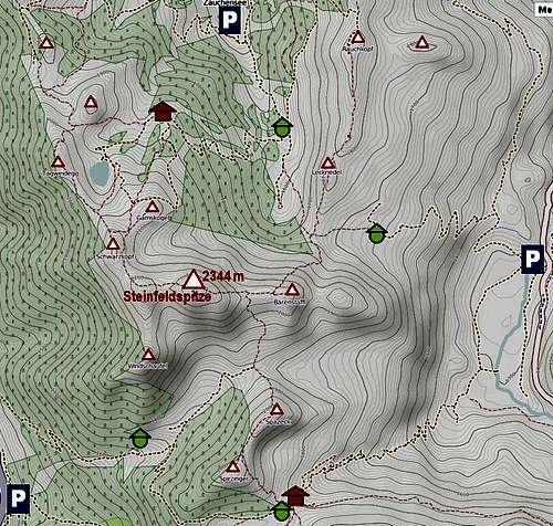
Getting There
The main starting point for tours on Steinfeldspitze is Zauchensee. We enter the valley from the north, from the town of Altenmarkt. At the end of public road, by the lower cable-car stations, there is a big parking place on 1361 m. From there, towards the east and south-west cable-cars go, but only in winter and summer. They can save you some boring walk up on higher altitudes.
From the south, ascents can start on Radstaette Tauernalm, 1200 m, where you can exit the highway Villach-Salzburg.
On the east, you can start the ascent on Vordergnadenalm, 1272 m, very close to the local road, which connects Radstadt and Obertauern Pass.
On the web, you can see a detailed map (1:50000) on: Austrianmap
Ascent Routes
|  West ridge route  On the E ridge Remark: Difficulties of routes sections are rated on the Swiss Scale for Hiking Tours (T1-T6). 1. From Zauchensee via W-NW ridge. By mountain roads (closed for public traffic) and ski slopes we ascend to the artificial lake in Seekarkessel, 1960 m, (T1 till here). From there we continue southwards on the saddle between Gamskogel and Schwarzkopf, and across the eastern slopes of the latter on the notch in the NW ridge of Steinfeldspitze. (T2 till here). Then by the W-NW ridge on top. (T4 the last section). From above the lake very nice hike, the last part very exposed, some easy climbing needed. Marked all the time. 3 h 30 min. 2. From Zauchensee via E ridge. By mountain roads (closed for public traffic) and shortcuts towards the S-SE on Oberzauchenseealm, 1556 m. Then by a good shepherds path further on Stubhoehe, 1739 m, (T1 till here). Then southwards on the main ridge (T2/T3 till here). Finally by the E ridge on top (T3 the last section). Nice hike up, the summit ridge is very fine and picturesque. Some secured passages and some exposed passages. 3 h 30 min. 3. From Radstaette Tauernalm there are more options to reach first Hafeichtalm, 1640 m, then further towards the NE we continue on Hafeichtscharte, 1838 m, then towards the N on the summit ridge and towards the west on top. Long approach. 4. From Vordergnadenalm we go by cart roads and shepherds paths towards the W on Stubhoehe, 1739 m, then as described above in route #2 on top. 3 h 30 min. |
Mountain Huts
In Zauchensee valley and above the tourist resort there are many hotels and private huts. Such a hut is Gamskogelhuette, 1878 m, north of Steinfeldspitze.
On the south of the mountain group, on Gnadenalm, already quite remote from Steinfeldspitze, stands Suedwiener Huette, 1801 m, which is the official mountain hut of Austrian Alpine Club.
When To Ascend?
| Steinfeldspitze is ascended mostly in dry seasons, so between June and October. Snow or even ice on the summit ridges can make the tour very serious, so in winter conditions full winter equipment will be required. For very good skiers, the descent over the south east ridge is possible, but it requires optimal conditions and its difficulty must be already on the border of alpinistic skiing. | Click for weather forecast |

Red Tape
There are no special restrictions. Even if above Zauchensee valley nature is very degraded, visitors should still (or even more) care about preserving the environment.Your Help Is Needed
If you have more information, please add, especially the following:> Other harder routes (besides the described marked and secured ones).
> Any experiences with winter ascents on Steinfeldspitze or with skiing from its summit.