


-
 9314 Hits
-
 88.6% Score
-
 27 Votes
|
|
Route |
|---|---|
|
|
45.83292°N / 6.86502°E |
|
|
Mountaineering |
|
|
Summer |
|
|
Most of a day |
|
|
From PD- to PD+; from PD+ to AD |
|
|
Note
|
La montagna chiama i suoi figli, ed essi rispondono fedelmente al suo appello… Osvaldo Cardellina, Diario alpinistico, 1964-65 Page texts: @ OsvaldoCardellina "Osva", passed away on May 2, 2022. Page owners: Christian Cardellina e Osvaldo Cardellina. Any updates from September 12, 2022: Antonio Giani, page administrator, friend and climbing companion. Testi della pagina: @ OsvaldoCardellina "Osva", scomparso il 2 maggio 2022. Proprietari pagina: Christian Cardellina e Osvaldo Cardellina. Eventuali aggiornamenti dal 12 settembre 2022: Antonio Giani, amministratore della pagina, amico e compagno di salite. |
Overview
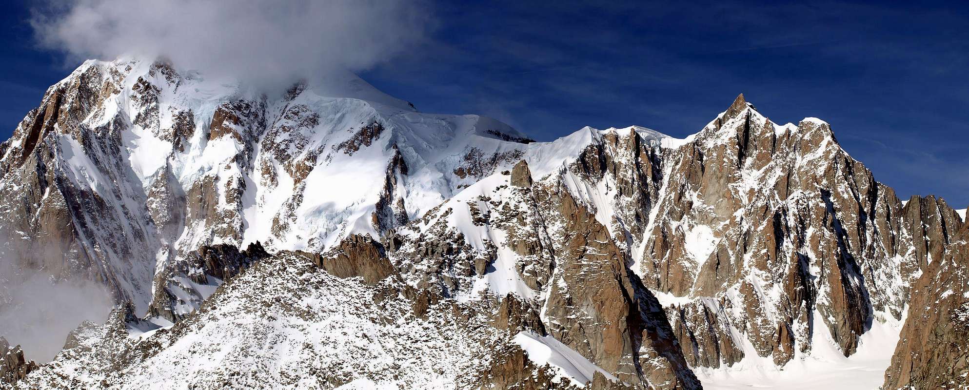
This great crossing of Mont Blanc (4.811m), than historical, may be considered for a long time a classical way, so that, at times, be the Normal Route to the same. History, because it marks the old Italian way to search for a maximum Summit Europe by the Guides of Courmayeur, in contrast to the French one of the first climbers of the Top. In fact, the ascent takes place entirely in French territory starting from the Col du Midi and to find the truly Italian way before it must wait for the Mount Blanc equally historic ascent along the Brenva Éperon probably covered by the Guides September 28th, 1854 Joseph Marie Chabod said Turin, Gratien Bareux Joseph Marie Chabod said Turisa, Alexis Clusaz, Alexandre Fenoillet, Joseph Marie and Alexis Perrod Proment. Surely the same was increased following eleven years, ie July 15th, 1865, by A.W. Moore, G.S. Mathews F. Walker, H. Walker with the famous Swiss Guides Jakob and Melchior Anderegg, and even today the road is known as "Via Moore". Two splendid enterprises, especially in view of the very scarce resources available at the time.
As regards the crossing in question there is to be noted that the same saw his first ascension August 13th, 1863 by R.W. Head with Guide Julien Grange said Laberge, Marie Joseph Adolphe Orset and Perrod, but the way had already been explored September 20th, 1854 until the Mur de la Cote (ice Coast Wall; attempts in 1854/55), thus solving in practice all the technical problems, by Joseph Marie Guides Cabod "Turin", Gratien Bareux, Joseph Marie Chabod "Turisa", Alexis Clusaz, Alexandre Fenoillet, Joseph Marie perrod and Alexis Proment, imitated the following year, July 31th, again by the "Turin" with J.H. Ramsey, Pierre Joseph Mochet nicknamed "Gros" and yet Joseph Marie Perrod. A diversification of the route takes place August 21th, 1895 when G.H. Morse, accompanied by the exceptional Mountai Guide Courmayeur Emile Rey, making the crossing but no more avoiding the two peaks of the Mount Blanc de Tacul and Mount Maudit, but climbing all three peaks, including that of Mount Blanc in a crossing then complete. To finally arrive at a crossing with full path no longer passes through the Col du Mont Maudit, but that the Western Summit of the Tacul falls to Col Maudit and reaches the large and Easstern shoulder of the Maudit, so inserting at the end of the Via Kuffner, July 1887, the performing J.S. Masterman with two renowned Swiss Mountain Guides Albert and Benedikt Supersaxo July 31th, 1898.
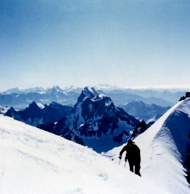
Ascent is not so difficult, as long and exposed to serac falls in the ascent of Mount Blanc of Tacul, where its North Slope occurred many misfortunes for this reason, it is very rarely carried out from the two Refuges Turin, while generally leaving the is from the reconstructed Refuge des Cosmiques on the Col du Midi, after the old one was burned down in the early Seventies. Occasion was made the bivouac slipping into the very small tunnels, including the remaining axes and remained trapped by ice. The proximity of the Glaciers Cable car to Aiguille du Midi (currently closed for renovations) favors this departure, but it is used as a result of the crossing in the opposite direction, even when returning from the various routes in ascents of Mount Blanc.
Is not difficult, but even from underneath evaluate in relation to the weather situation and that in any case requires a departure night, certainly more secure.
As regards the crossing in question there is to be noted that the same saw his first ascension August 13th, 1863 by R.W. Head with Guide Julien Grange said Laberge, Marie Joseph Adolphe Orset and Perrod, but the way had already been explored September 20th, 1854 until the Mur de la Cote (ice Coast Wall; attempts in 1854/55), thus solving in practice all the technical problems, by Joseph Marie Guides Cabod "Turin", Gratien Bareux, Joseph Marie Chabod "Turisa", Alexis Clusaz, Alexandre Fenoillet, Joseph Marie perrod and Alexis Proment, imitated the following year, July 31th, again by the "Turin" with J.H. Ramsey, Pierre Joseph Mochet nicknamed "Gros" and yet Joseph Marie Perrod. A diversification of the route takes place August 21th, 1895 when G.H. Morse, accompanied by the exceptional Mountai Guide Courmayeur Emile Rey, making the crossing but no more avoiding the two peaks of the Mount Blanc de Tacul and Mount Maudit, but climbing all three peaks, including that of Mount Blanc in a crossing then complete. To finally arrive at a crossing with full path no longer passes through the Col du Mont Maudit, but that the Western Summit of the Tacul falls to Col Maudit and reaches the large and Easstern shoulder of the Maudit, so inserting at the end of the Via Kuffner, July 1887, the performing J.S. Masterman with two renowned Swiss Mountain Guides Albert and Benedikt Supersaxo July 31th, 1898.
Ascent is not so difficult, as long and exposed to serac falls in the ascent of Mount Blanc of Tacul, where its North Slope occurred many misfortunes for this reason, it is very rarely carried out from the two Refuges Turin, while generally leaving the is from the reconstructed Refuge des Cosmiques on the Col du Midi, after the old one was burned down in the early Seventies. Occasion was made the bivouac slipping into the very small tunnels, including the remaining axes and remained trapped by ice. The proximity of the Glaciers Cable car to Aiguille du Midi (currently closed for renovations) favors this departure, but it is used as a result of the crossing in the opposite direction, even when returning from the various routes in ascents of Mount Blanc.
Is not difficult, but even from underneath evaluate in relation to the weather situation and that in any case requires a departure night, certainly more secure.
 |
Questa grande traversata del Monte Bianco (4.811 m), oltreché storica, può essere considerata ormai da molto tempo una via classica, tanto da, a volte, costituire la Via Normale al medesimo. Storica, poiché segna l'antica ricerca di una via italiana alla massima Sommità di Europa da parte delle Guide di Courmayeur, in contrapposizione a quella francese dei primi salitori della Cima. In realtà la salita avviene completamente in territorio francese con partenza dal Col du Midi e per trovare la prima via veramente italiana al Bianco si deve attendere la altrettanto storica salita lungo lo Sperone della Brenva, probabilmente percorsa il 28 Settembre 1854 dalle Guide Joseph Marie Chabod detto Turin, Gratien Bareux J.M. Chabod detto Turisa, Alexis Clusaz, Alexandre Fenoillet, Joseph Marie Perrod ed Alexis Proment. Sicuramente il medesimo fu salito undici anni appresso, ovvero il 15 Luglio 1865, da parte di A.W. Moore, G.S. Mathews F. Walker, H. Walker con le famose Guide Svizzere Jakob e Melchior Anderegg, tanto che ancora oggi la via é conosciuta come "Via Moore". Due splendide imprese, soprattutto in considerazione dei mezzi veramente scarsi a disposizione dell'epoca.
Per quanto concerne la traversata in questione vi é da rilevare che la medesima vide la sua prima ascensione il 13 Agosto 1863 da parte di R.W. Head con le Guide Julien Grange detto Laberge, Adolphe Orset e Joseph Marie Perrod, ma la via era già stata esplorata il 20 Settembre 1854 fino al Mur de la Cote (tentativi del 1854/55), risolvendo quindi in pratica tutti i problemi tecnici esistenti, da parte delle Guide Joseph Marie Cabod "Turin", Gratien Bareux, Joseph Marie Chabod "Turisa", Alexis Clusaz, Alexandre Fenoillet, Joseph Marie Perrod ed Alexis Proment, imitati l'anno successivo, il 31 Luglio, sempre da "Turin" insieme a J.H. Ramsey, Pierre Joseph Mochet soprannominato "Gros" ed ancora Joseph Marie Perrod. Una diversificazione all'itinerario avviene il 21 Agosto 1895 allorché G.H. Morse, accompagnato dall'eccezionale Guida di Courmayeur Emile Rey, effettuano la traversata ma non più evitando le due Cime del Mont Blanc de Tacul e del Maunt Maudit, bensì salendo tutte e tre le vette, quella del Monte Bianco compresa in una traversata quindi completa. Per giungere infine ad una traversata integrale con percorso non transitante più pel Col del Mont Maudit, ma che dalla Cima Ovest del Tacul discende al Col Maudit e raggiunge la grande spalla Orientale del Maudit, così inserendosi nella parte finale della Via Kuffner del Luglio 1887; lo effettuano J.S. Masterman con le due rinomate Guide svizzere Albert e Benedikt Supersaxo il 31 Luglio 1898.
Ascensione non tanto difficile, quanto lunga ed esposta a cadute di seracchi nella salita al Mont Blanc de Tacul, ove sul suo Versante Settentrionale si son verificate numerose disgrazie per codesta ragione; viene molto raramente effettuata partendo dai due Rifugi Torino, mentre in genere la partenza inizia dal ricostruito Refuge des Cosmiques al Col du Midi, dopo che il vecchio era andato a fuoco agli inizi degli Anni Settanta. Nell'occasione si effettuava il bivacco infilandosi negli più che angusti cunicoli, tra le residue assi rimaste ed imprigionate dai ghiacci. La vicinanza della Funivia dei Ghiacciai all'Aiguille du Midi (attualmente chiusa per lavori di ristrutturazione) favorisce questa partenza, ma é utilizzata, a seguito della traversata in senso contrario, anche al ritorno dalle varie vie di salita al Monte Bianco.
Salita non difficile, ma neppure da sotto valutare anche in rapporto alla situazione meteo e che comunque richiede una partenza notturna, sicuramente più sicura.
 |
Getting There
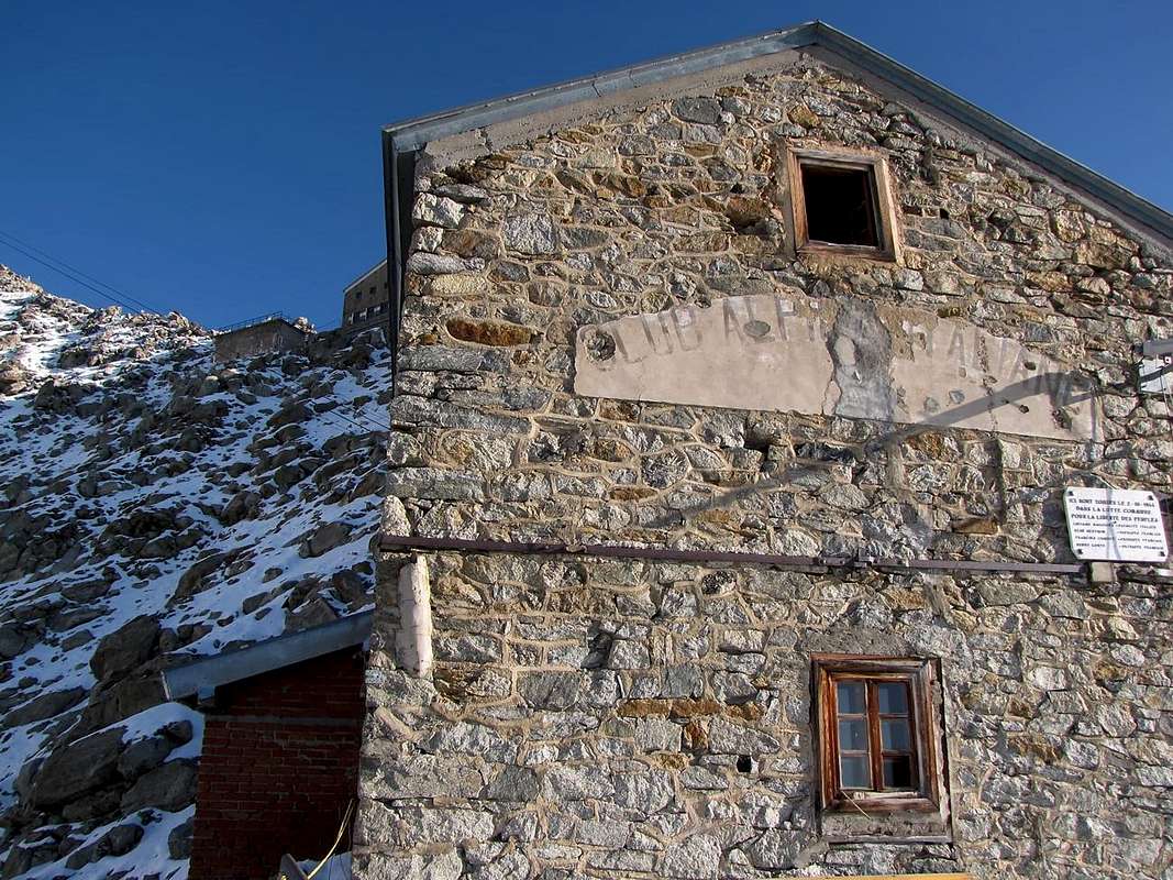
- From Chamonix-Mount Blanc (France) or from Courmayeur-la Palud through the Cable car "of the Glaciers" up the Aiguille du Midi (3.795m), the Italian is currently closed for restoration and renovation. Otherwise from Courmayeur Resort with the old path of the Pavillon for the two Refuges Torino, Old and New (3.371 m), and crossing the Glacier du Géant and the Vallée Blanche to the Refuge des Cosmiques (3.613m) just above the Col du Midi (3.516m).
Da Chamonix-Mont Blanc (Francia) o da Courmayeur-la Palud tramite la "Funivia dei Ghiacciai" fino all'Aiguille du Midi (3.795 m); la parte italiana attualmente é chiusa per lavori di restauro e ristrutturazione. Altrimenti da Cormayeur con il vecchio sentiero del Pavillon per i due Rifugi Torino, Vecchio e Nuovo (3.371 m), e traversata del Ghiacciaio del Gigante e la Vallée Blanche fino al Refuge des Cosmiques (3.613 m), appena al di sopra del Col du Midi (3.516).
Approach from Refuges Torino towards Giants Glacier
Quite different is this ascension, per se already quite long, starting directly from one of the two shelters Turin (3.334m, 3.371m), at the Colle del Gigante and just below the Punta Helbronner.
Crossing the Glacier du Géant and the upper part of the Vallée Blanche requires an additional two hours, in the case of return by the same route, become four, and also something more, when fatigue begins to advance.
Built in 1898 and opened by the Section of the C.A.I, of Turin, the New, above, is the property by Sections of Aosta and Turin, and was positioned on the promontory where there was the ancient Capanna (Hut) Margherita, later demolished. These shelters, together with Quintino Sella Refuge 1885 Rochers, the Shack-Vallot Observatory, 1890, the Plan de l'Aiguille, 1890, at the Refuge Francesco Gonella, 1891 at the Dôme, the Refuge Charles Henri Durier 1899 at Col du Miage, the Gôuter 1906, at the Chatelet Gamba Hut of 1912 (current Refuge Monzino), the Hotellerie des Grands Mulets of 1853, the first shelter in the Mountain Chain of Mount Blanc, the Montervers, Couvercle, Charpoua etc. mark, step by step, the history of this great mountain from the generic "Mont Maudit" became, thanks to the explorations and ascents, Mount Blanc.
For those who want to go back to those old tracks that exude sacrifice and glory climbing, trail n° 20, from Courmayeur-La Palud (1.370m) , rises to the Refuge de Pavillon at Mount Fréty (2.174m, the first section of the Cablecar) and then enter on the great Southeast Ridge that descends from Punta Helbronner (3.462m; culmination of that before continuing, as the gondola to Aiguille du Midi, 3.842m) to finally get on a track in succession the two shelters (* be careful, snow up to mid-July). The history of these mountains passes through their shelters and camps, but also through their paths, for which reason it is worthwhile to smell the powder.
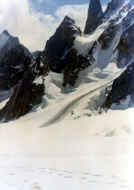
Let's see in detail this crossing, which is also a classic of mountain skiing with downhill to the Valley Chamonix-Mont Blanc: from Turin Shelter cross with moderate descent Northeast reaching down to the Giant Pass (3.365m), at the beginning of glacier with the same name; changing direction in the opposite direction, reaching in a short time to the Flambeaux Hill (about 3.400 meters), between Grand/Petit Flambeau. From this begin a descent towards the West-northwest through a long diagonal (traces of transition on the glacier with large crevasses, generally, already open) below the watershed Italian/French from the Aiguilles des Thoules that goes to the Tour Ronde, with a semicircular route around 3.300 meters. Leaving on the left the "Cirque Maudit", including the Tour Ronde/Mount Maudit/Tacul/Aiguilles du Diable, go to the area of "Satellites" by Mount Blanc de Tacul. Passing beneath these famous granite peaks, among which emerges the Grand Capucin, still down to 3.150 meters below the big channels/couloirs Eastern Tacul (4.247m), gradually abandon the Glacier du Géant to enter the Vallée Blanche, at the top of the area known as "the Bedière". Continue, more to the North, in the direction of the Col du Gros Rognon (3.415m), between the Gros Rognon/Pointe Louis Lachenal. Do not reach it but, keeping to the left towards the rocky point 3.448 meters, below the Quote 3.570 met
Crossing the Glacier du Géant and the upper part of the Vallée Blanche requires an additional two hours, in the case of return by the same route, become four, and also something more, when fatigue begins to advance.
Built in 1898 and opened by the Section of the C.A.I, of Turin, the New, above, is the property by Sections of Aosta and Turin, and was positioned on the promontory where there was the ancient Capanna (Hut) Margherita, later demolished. These shelters, together with Quintino Sella Refuge 1885 Rochers, the Shack-Vallot Observatory, 1890, the Plan de l'Aiguille, 1890, at the Refuge Francesco Gonella, 1891 at the Dôme, the Refuge Charles Henri Durier 1899 at Col du Miage, the Gôuter 1906, at the Chatelet Gamba Hut of 1912 (current Refuge Monzino), the Hotellerie des Grands Mulets of 1853, the first shelter in the Mountain Chain of Mount Blanc, the Montervers, Couvercle, Charpoua etc. mark, step by step, the history of this great mountain from the generic "Mont Maudit" became, thanks to the explorations and ascents, Mount Blanc.
For those who want to go back to those old tracks that exude sacrifice and glory climbing, trail n° 20, from Courmayeur-La Palud (1.370m) , rises to the Refuge de Pavillon at Mount Fréty (2.174m, the first section of the Cablecar) and then enter on the great Southeast Ridge that descends from Punta Helbronner (3.462m; culmination of that before continuing, as the gondola to Aiguille du Midi, 3.842m) to finally get on a track in succession the two shelters (* be careful, snow up to mid-July). The history of these mountains passes through their shelters and camps, but also through their paths, for which reason it is worthwhile to smell the powder.
Let's see in detail this crossing, which is also a classic of mountain skiing with downhill to the Valley Chamonix-Mont Blanc: from Turin Shelter cross with moderate descent Northeast reaching down to the Giant Pass (3.365m), at the beginning of glacier with the same name; changing direction in the opposite direction, reaching in a short time to the Flambeaux Hill (about 3.400 meters), between Grand/Petit Flambeau. From this begin a descent towards the West-northwest through a long diagonal (traces of transition on the glacier with large crevasses, generally, already open) below the watershed Italian/French from the Aiguilles des Thoules that goes to the Tour Ronde, with a semicircular route around 3.300 meters. Leaving on the left the "Cirque Maudit", including the Tour Ronde/Mount Maudit/Tacul/Aiguilles du Diable, go to the area of "Satellites" by Mount Blanc de Tacul. Passing beneath these famous granite peaks, among which emerges the Grand Capucin, still down to 3.150 meters below the big channels/couloirs Eastern Tacul (4.247m), gradually abandon the Glacier du Géant to enter the Vallée Blanche, at the top of the area known as "the Bedière". Continue, more to the North, in the direction of the Col du Gros Rognon (3.415m), between the Gros Rognon/Pointe Louis Lachenal. Do not reach it but, keeping to the left towards the rocky point 3.448 meters, below the Quote 3.570 met
res of Lachenal, land in the upper basin of the Blanche Valley, and from this, rounding the same, addressing the Northwest get near the large glacial saddle of the Col du Midi (3.516/32m). Discarding the same immediately to the left (west), go up instead of North towards the Aiguille du Midi reaching the Refuge des Cosmiques (3.613m), perched on the edge of the Ridge South-southwest that comes from this (2h'00/2h'30).
 |
 |
 |
 |
 |
Ben diversa risulta questa ascensione, di per se già abbastanza lunga, partendo direttamente da uno dei due Rifugi Torino (3.334 m, 3.371 m), presso il Colle del Gigante ed appena sotto la Punta Helbronner.
La traversata del Glacier du Géant e della parte superiore della Vallée Blanche richiede un supplemento di altre due ore che, nel caso di rientro tramite la stessa via, diventano quattro ed anche qualcosa di più, allorché la fatica incomincia ad avanzare.
Costruito nel 1898 e inaugurato da parte della Sezione del C.A.I. di Torino; il soprastante Nuovo é di proprietà delle Sezioni di Aosta e Torino ed é stato edificato sul promontorio dove esisteva l'antica Capanna Margherita, in seguito demolita. Questi rifugi, insieme Rifugio Quintino Sella del 1885 ai Rochers, alla Capanna-Osservatorio Vallot del 1890, al Plan de l'Aiguille del 1890, al Rifugio Gonella del 1891 al Dôme, al Refuge Charles Henri Durier del 1899 al Col du Miage, al Gôuter del 1906, alla Capanna Gamba al Chatelet del 1912 (attuale Monzino), all'Hotellerie des Grands Mulets del 1853, il primo rifugio nella Catena del Monte Bianco, ai Montervers, Couvercle, Charpoua ecc. segnano, passo dopo passo, la storia di questa grande montagna che dal generico "Mont Maudit" diventò, grazie alle esplorazioni ed alle ascensioni, il Monte Bianco.
Per chi vuole percorrere nuovamente quelle vecchie tracce che trasudano di sacrifici e gloria alpinistica, un sentiero n° 20 parte da La Palud (1.370 m), sale al Refuge de Pavillon al Mont Fréty (2.174 m; primo troncone della Funivia) per poi inserirsi sul crestone Sudest che scende da Punta Helbronner (3.462 m; punto di arrivo della medesima prima di proseguire, come cabinovia, verso l'Aiguille du Midi, 3.842 m) per infine raggiungere su di una traccia in successione i due rifugi (* attenzione, neve fino a metà di Luglio). La storia di queste montagne passa attraverso i loro rifugi e bivacchi, ma anche attraverso i loro sentieri, per cui val la pena d'odorarne la polvere.
Vediamo nel dettaglio la traversata costituente, inoltre, una classica dello sci-alpinismo con discesa fino alla Valle di Chamonix-Mont Blanc: dal Torino attraversare con moderata discesa a Nordest raggiungendo il Colle del Gigante (3.365 m), all'inizio dell'omonimo ghiacciaio; cambiando direzione in senso opposto, pervenire in breve al Col des Flambeaux (3.400 metri circa), tra Petit/Grand Flambeau. Da questo punto iniziare verso Ovest-nordovest una discesa con un lungo diagonale (tracce sul ghiacciaio con grandi crepacce, generalmente, già aperte) sottostante lo spartiacque italo/francese che va dall'Aiguilles des Thoules sin verso la Tour Ronde; con giro semicircolare a quota 3.300 metri circa, lasciando a sinistra il "Cirque Maudit", tra Tour Ronde/Mont Maudit/Tacul/Aiguilles du Diable, portarsi nella zona dei "Satelliti" del Mont Blanc de Tacul. Passando al di sotto di queste celebri cime granitiche, tra le quali emerge il Grand capucin, ancora in discesa verso i 3.150 metri circa e sotto i canaloni Orientali del Tacul Est (4.247 m), abbandonare progressivamente il Ghiacciaio del Gigante per entrare nella Vallée Blanche, nella parte superiore di quell'area detta "la Bedière". Proseguire, più verso Nord, in direzione del Col du Gros Rognon (3.415 m), tra il Gros Rognon e la Pointe Louis Lachenal. Non raggiungerlo ma, tenendosi più a sinistra verso il punto roccioso 3.448 metri, sottostante la Quota 3.570 metri della Lachenal, approdare nel bacino superiore della Vallée Blanche; doppiando questa punta ed indirizzandosi a Nordovest arrivare nei pressi della larga sella glaciale del Col du Midi (3516/32 m). Scartandolo subito a sinistra (Ovest), salire invece verso Nord in direzione dell'Aiguille du Midi raggiungendo il Refuge des Cosmiques (3.613 m), appollaiato ai margini della Cresta Sud-sudovest proveniente da questa (2h '00/2h '30).
![]()
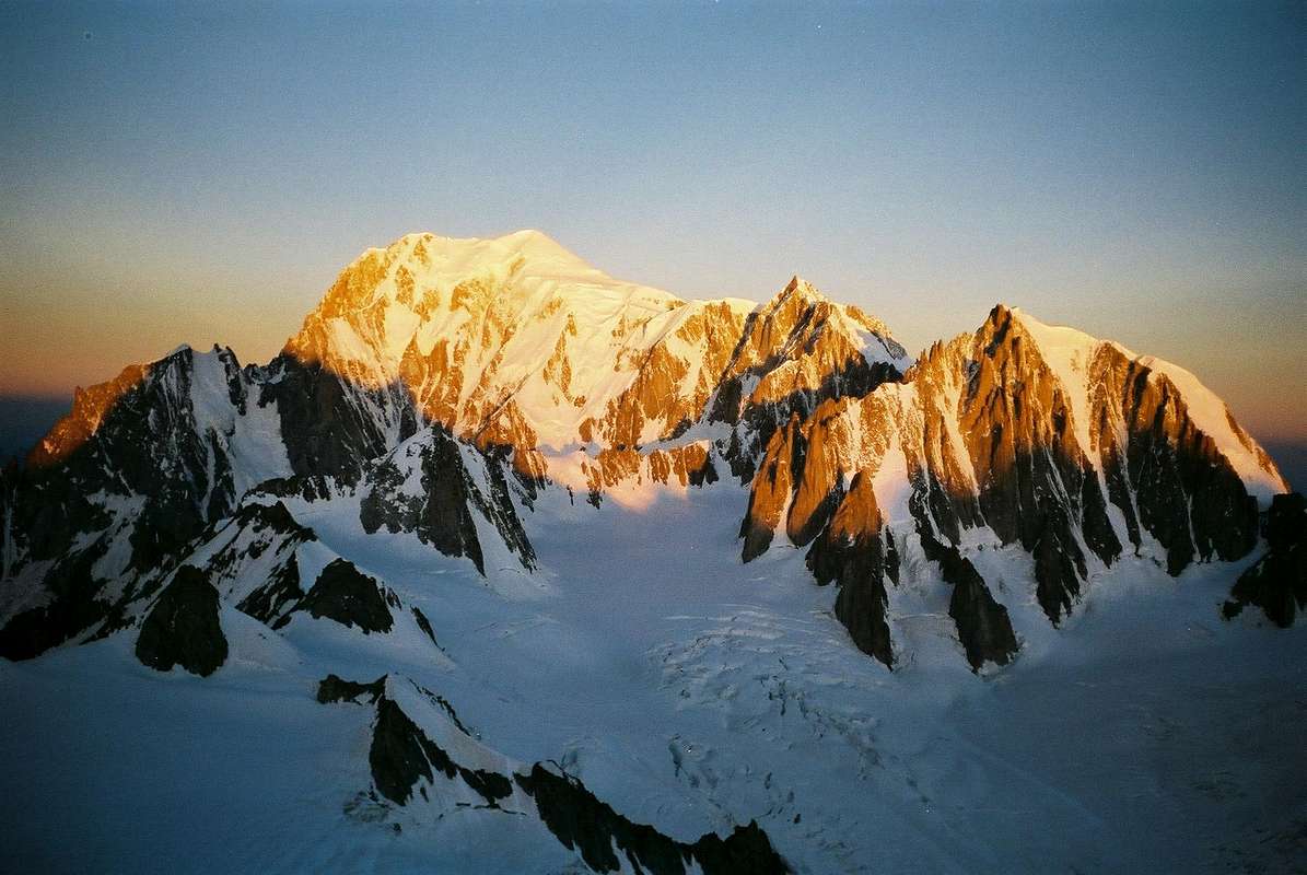
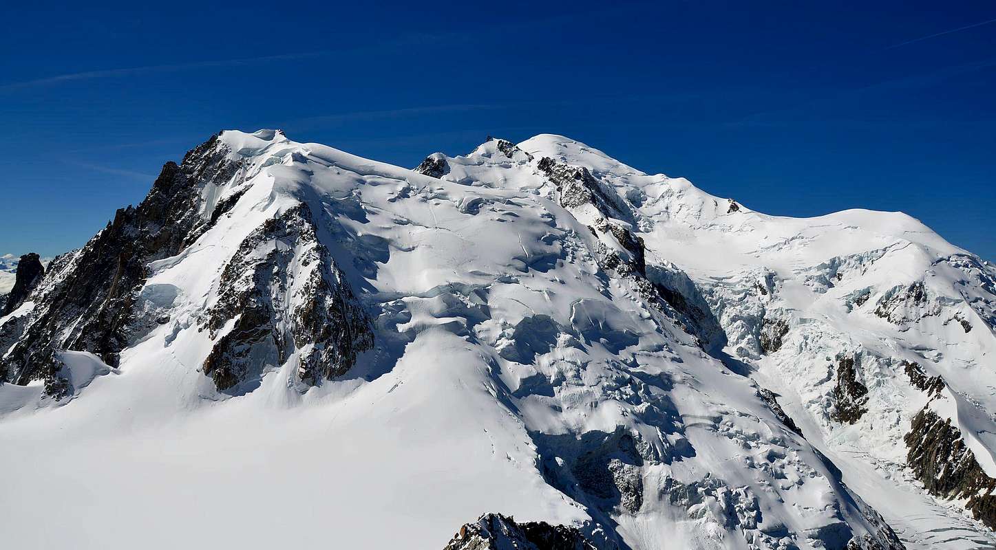
"Classic from Col du Midi or North", by om
La traversata del Glacier du Géant e della parte superiore della Vallée Blanche richiede un supplemento di altre due ore che, nel caso di rientro tramite la stessa via, diventano quattro ed anche qualcosa di più, allorché la fatica incomincia ad avanzare.
Costruito nel 1898 e inaugurato da parte della Sezione del C.A.I. di Torino; il soprastante Nuovo é di proprietà delle Sezioni di Aosta e Torino ed é stato edificato sul promontorio dove esisteva l'antica Capanna Margherita, in seguito demolita. Questi rifugi, insieme Rifugio Quintino Sella del 1885 ai Rochers, alla Capanna-Osservatorio Vallot del 1890, al Plan de l'Aiguille del 1890, al Rifugio Gonella del 1891 al Dôme, al Refuge Charles Henri Durier del 1899 al Col du Miage, al Gôuter del 1906, alla Capanna Gamba al Chatelet del 1912 (attuale Monzino), all'Hotellerie des Grands Mulets del 1853, il primo rifugio nella Catena del Monte Bianco, ai Montervers, Couvercle, Charpoua ecc. segnano, passo dopo passo, la storia di questa grande montagna che dal generico "Mont Maudit" diventò, grazie alle esplorazioni ed alle ascensioni, il Monte Bianco.
Per chi vuole percorrere nuovamente quelle vecchie tracce che trasudano di sacrifici e gloria alpinistica, un sentiero n° 20 parte da La Palud (1.370 m), sale al Refuge de Pavillon al Mont Fréty (2.174 m; primo troncone della Funivia) per poi inserirsi sul crestone Sudest che scende da Punta Helbronner (3.462 m; punto di arrivo della medesima prima di proseguire, come cabinovia, verso l'Aiguille du Midi, 3.842 m) per infine raggiungere su di una traccia in successione i due rifugi (* attenzione, neve fino a metà di Luglio). La storia di queste montagne passa attraverso i loro rifugi e bivacchi, ma anche attraverso i loro sentieri, per cui val la pena d'odorarne la polvere.
Vediamo nel dettaglio la traversata costituente, inoltre, una classica dello sci-alpinismo con discesa fino alla Valle di Chamonix-Mont Blanc: dal Torino attraversare con moderata discesa a Nordest raggiungendo il Colle del Gigante (3.365 m), all'inizio dell'omonimo ghiacciaio; cambiando direzione in senso opposto, pervenire in breve al Col des Flambeaux (3.400 metri circa), tra Petit/Grand Flambeau. Da questo punto iniziare verso Ovest-nordovest una discesa con un lungo diagonale (tracce sul ghiacciaio con grandi crepacce, generalmente, già aperte) sottostante lo spartiacque italo/francese che va dall'Aiguilles des Thoules sin verso la Tour Ronde; con giro semicircolare a quota 3.300 metri circa, lasciando a sinistra il "Cirque Maudit", tra Tour Ronde/Mont Maudit/Tacul/Aiguilles du Diable, portarsi nella zona dei "Satelliti" del Mont Blanc de Tacul. Passando al di sotto di queste celebri cime granitiche, tra le quali emerge il Grand capucin, ancora in discesa verso i 3.150 metri circa e sotto i canaloni Orientali del Tacul Est (4.247 m), abbandonare progressivamente il Ghiacciaio del Gigante per entrare nella Vallée Blanche, nella parte superiore di quell'area detta "la Bedière". Proseguire, più verso Nord, in direzione del Col du Gros Rognon (3.415 m), tra il Gros Rognon e la Pointe Louis Lachenal. Non raggiungerlo ma, tenendosi più a sinistra verso il punto roccioso 3.448 metri, sottostante la Quota 3.570 metri della Lachenal, approdare nel bacino superiore della Vallée Blanche; doppiando questa punta ed indirizzandosi a Nordovest arrivare nei pressi della larga sella glaciale del Col du Midi (3516/32 m). Scartandolo subito a sinistra (Ovest), salire invece verso Nord in direzione dell'Aiguille du Midi raggiungendo il Refuge des Cosmiques (3.613 m), appollaiato ai margini della Cresta Sud-sudovest proveniente da questa (2h '00/2h '30).
Route A Classic Passage
This is the "Via Classica" of ascent but also, as mentioned above, descent, where this term is meant to signify the path of most, if not exclusive, passing all roped climbing Mount Blanc or return by the same. Despite the fact that the two Summits of the Mount Blanc de Tacul are avoided by "cutting" the route on the great Western Shoulder of the first and the Col du Mount Maudit for the second, which remains a long way with all the considerations already expressed in OVERVIEW requires good weather and stable, and an adaptation to altitude, good degree of preparation and training. Let's see in detail: from the Col du Midi (3.516m) or, better, from the just above Refuge des Cosmiques (3.613m) via a short descent to the same; crossed to the South the large glacial saddle (not recommended on the crossing to the West most Eastern branch of the Glacier des Bossons) to reach the base of the North Slope of Tacul at an altitude of 3.600 meters. With a climb of moderate slope (from 30° to 35°) you will come progressively to the right ( West) passing the first of the three bands glacial (hanging seracs) in this direction , the other two are overcome with a slope greater ( from 38° to 40°) in the opposite direction to reach a vast plateau sloping almost to the far left (East) of the same. A long diagonal, leads again to the right, passing immediately to the side of a iced hump, about 4.000 meters, and from this point to climb almost vertically, but leaning slightly more to the left, leaving a large icefall in the opposite direction to the seracs Bossons, you reach a crevasse very long which descends diagonally from East to West breaking in two face (40°). The first centrally and then you pass out on the right, with the consideration that in the years 1970/74 the passage of the same was not so simple as to require a small human pyramid in order to fit the ax above his upper lip, usually overflowing to the underlying (43°/45°, to keep in mind that the tools of that time did not allow the technical piolet-traction). With a final part easier and descending slope you reach the large Western Tacul Shoulder midway between the points 4.187/4.100 meters, a short and easy descent leads to extensive glacial plateau around 4.010/20 meters, between the Top of the Western Tacul (4.248m) and Mount Maudit (4.468m; 2h'00/2h'30 by Cosmiques, 4h'30 from Refuge Torino). Crossing the same to the right , just below the Col Maudit (4.035m) taking progressively under the Col du Mount Maudit (4.345m) and exactly at 4.000 meters. Traced directly to the crevasse (30°/33°) that exceeds directly, or it can force you to bypass any right or left, "appearing" in the upper slope or North Wall, but after about fifty metres, turn sharply to the right (West) focusing on the directive comes down from the Col du Mount Maudit; these 250 meters progressively increase in slope (35°/37° to 45° and above) and create some difficulty if they are " verglass", even if the existing tools diminish somewhat the problem than those who had to carve the steps proceeding with technical edge traversal (usually near the top of the slope is driven in the snow left by the mountain guides a small wooden pole to facilitate descent). From the pass with a crossing slightly downhill we reach the Brenva Pass (4.303m; 2h '00 from the shoulder; 4h'15/4h'30 by Cosmiques). Rise, leaving West it to the Rochers Rouges Lower, Upper and Little along the North Slope of Mount Blanc via what is better known as "Mur de la Cote" with 500 meters of ascent is not very steep but always considered "hard", especially psychologically (2h'15/2h'30; 6h'00/6h'30 by Cosmiques; 8h'30/10h'00 from Torino two Shelters, very variable as a result of the conditions).
Descend via the Ridge West-northwest towards the "Rochers de la Tournette" (4.677m) and the two subsequent Petite (4.509m) and Grande Bosses (4.335m), just above the Observatory-Vallot Hut (4.362m) at the "Rochers Foudroyés" (rocks struck by lightning); quickly and easily you can reach the Col du Dôme (4.240m), from which the various routes of descent. Instead go back to the Northwest, via an easy slope, near the Dôme du Gôuter (4.306m), which concludes the first crossing of the various possibilities of descent, which we analyze separately.
Descend via the Ridge West-northwest towards the "Rochers de la Tournette" (4.677m) and the two subsequent Petite (4.509m) and Grande Bosses (4.335m), just above the Observatory-Vallot Hut (4.362m) at the "Rochers Foudroyés" (rocks struck by lightning); quickly and easily you can reach the Col du Dôme (4.240m), from which the various routes of descent. Instead go back to the Northwest, via an easy slope, near the Dôme du Gôuter (4.306m), which concludes the first crossing of the various possibilities of descent, which we analyze separately.
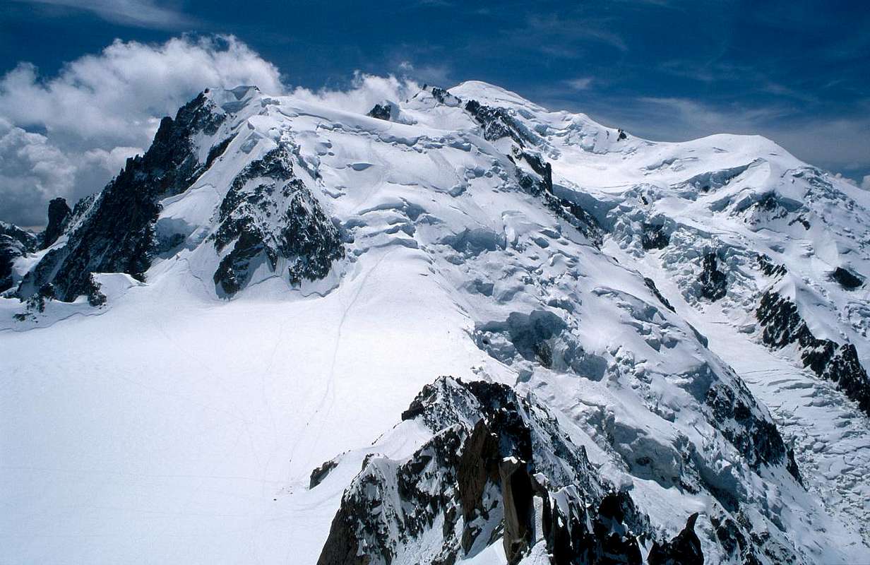 |
Questa costituisce la "Via Classica" di salita ma anche, come detto sopra, di discesa, dove con questo termine si intende significare il percorso di maggior, se non di esclusivo, passaggio di tutte le cordate in salita al Monte Bianco o in rientro dal medesimo. Nonostante che le due Cime del Mont Blanc de Tacul siano evitate "tagliando" il percorso sullo Spallone Occidentale del primo e sul Col del Mont Maudit per il secondo, rimane una via lunga che con tutte le considerazioni già espresse in OVERVIEW richiede tempo buono e stabile, adattamento all'altitudine ed un buon grado di preparazione e di allenamento. Vediamo nel dettaglio: partenza da Col du Midi (3.516 m) o, meglio, dall'appena soprastante Refuge des Cosmiques (3.613 m) tramite una breve discesa verso il medesimo; attraversata verso Sud la larga sella glaciale (assolutamente sconsigliabile l'attraversamento ad Ovest nonché relativa discesa sul ramo più Orientale del Glacier des Bossons) si arriva alla base del Versante Settentrionale del Tacul a quota 3.600 m). Con una salita di moderata pendenza (dai 30° ai 35°) ci si porta progressivamente verso destra (Ovest) superando la prima delle tre fasce glaciali con seracchi sospesi in questa direzione; le altre due vengono superate con una pendenza maggiore (da 38° a 40°) in direzione opposta raggiungendo un vasto plateau inclinato quasi all'estrema sinistra (Est) del medesimo. Un lungo diagonale, nuovamente a destra conduce, passando subito a fianco d'una gobba glaciale, a 4.000 m circa; da questo punto con salita quasi in verticale, ma poggiando appena più a sinistra e lasciando nel senso opposto una grande cascata di seracchi verso i Bossons, si raggiunge una crepaccia molto lunga che scende in diagonale da Est ad Ovest spezzando in due la faccia (40°). La si supera dapprima centralmente e poi uscendo a destra, con la considerazione che negli anni 1970/74 il passaggio della medesima non era così semplice e tale da richiedere una piccola piramide umana onde infilare la piccozza sopra il labbro superiore, in genere debordante al sottostante (43°/45°; da tenere presente che gli attrezzi di quel tempo non consentivano la tecnica di piolet-traction). Con una parte finale più facile ed in pendenza decrescente si raggiunge il largo Spallone Occidentale del Tacul a metà strada tra i punti 4.187/4.100 metri; una breve e facile discesa porta al vasto plateau glaciale circa 4.010/20 metri, tra la Punta Ovest del Tacul (4.248 m) ed il Mont Maudit (4.468 m; 2h'00/2h'30 dai Cosmiques; 4h'30 dal Rifugio Torino). Attraversare verso destra il medesimo, appena al di sotto del Col Maudit (4.035 m) portandosi progressivamente sotto il Col du Mont Maudit (4.345 m) ed esattamente a quota 4.000 m. Risalire direttamente verso la crepaccia terminale (30°/33°) che si supera direttamente, oppure può costringere a qualche aggiramento a destra o sinistra, "entrando" nel pendio superiore o parete Nord ma, dopo una cinquantina di metri, volgere decisamente a destra (Ovest) puntando sulla direttiva che scende dal Col du Mont Maudit; questi 250 metri aumentano progressivamente in pendenza (da 35°/37° a 45° ed oltre) e creano qualche difficoltà se sono in "verglass", anche se gli attrezzi attuali sminuiscono alquanto il problema rispetto a chi doveva intagliare dei gradini procedendo con tecnica di salita traversale (in genere quasi in cima al pendio viene lasciato dalle guide infisso nella neve un paletto in legno per favorirne la discesa). Dal colle con una traversata in leggera discesa si raggiunge il Colle della Brenva (4.303 m; 2h'00 dalla spalla; 4h'15/4h'30 dai Cosmiques). Salire, lasciando ad Ovest i Rochers Rouges Inferiori, Superiori e Petis, lungo il Versante Settentrionale del Monte Bianco tramite quello che viene maggiormente conosciuto come "Mur de la Cote" con 500 metri di dislivello non molto ripidi ma sempre considerati "duri" soprattutto psicologicamente (2h'15/2h'30; 6h'00/6h'30 dai Cosmiques; 8h '30/10h'00 dal Rifugio Torino, molto variabile a seguito delle condizioni).
Scendere tramite la Cresta Ovest-nordovest verso i "Rochers de la Tournette" (4.677 m) e le due successive Petite (4.509 m) e Grande Bosses (4.335 m), appena al di sopra dell'Osservatorio-Rifugio Vallot (4.362 m) presso i "Rochers Foudroyés" (rocce colpite dal fulmine); in breve tempo e facilmente si raggiunge il Col du Dome (4.240 m), dal quale si dipartono diverse vie di discesa. Risalire invece verso Nordovest, tramite un facile pendio, il vicino Dôme du Gôuter (4.306 m), dove si conclude la traversata prima delle varie possibilità di discesa, che analizzeremo a parte.
![]()
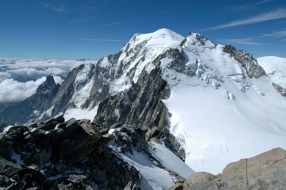
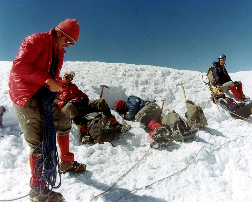
"Complete from North-northwest", by Antonio
Scendere tramite la Cresta Ovest-nordovest verso i "Rochers de la Tournette" (4.677 m) e le due successive Petite (4.509 m) e Grande Bosses (4.335 m), appena al di sopra dell'Osservatorio-Rifugio Vallot (4.362 m) presso i "Rochers Foudroyés" (rocce colpite dal fulmine); in breve tempo e facilmente si raggiunge il Col du Dome (4.240 m), dal quale si dipartono diverse vie di discesa. Risalire invece verso Nordovest, tramite un facile pendio, il vicino Dôme du Gôuter (4.306 m), dove si conclude la traversata prima delle varie possibilità di discesa, che analizzeremo a parte.
 |
 |
 |
 |
 |
Route B Complete Crossing
A) - Via a) - : the large shoulder of Mount Blanc de Tacul give up on the right (West) the "Normal Route" for Mount Blanc and turn left (East) and, using climb with moderate slope (30°/32°), reaching the base of the little castle of red rocks that forms the Summit of the Western Tacul, going around to his left, and letting down the spiraling couloir that goes down to 800 meters ("Couloir Gervasutti") above the Glacier du Géant, with granite blocks stacked to reach the Top. This path was followed for the first time by a single component of the a group of roped climbers Hudson-Kennedy and his companions in an attempt to Mount Blanc from Col du Midi,in the August 8th, 1855, "leaved" the big fellow 's shoulder, reached the Summit. The first ascent is certain, however, that the June 26th, 1882 by H. Duhamel and Pierre Gaspard and his son, who arrived in the middle of a rope away completely to the left of the North Slope, and perhaps never repeated that today, however, it is not most viable and somewhat dangerous for the current ice situation with many seracs suspended. In addition through a short traverse to the East you can reach quite easily even the Eastern Summit (4.247m), only one meters lower.
Via b) - : from the center of the North Slope, the above three glacial bands and the long crevasse before the diagonal, by an initial diagonal climb directly to the Summit, thus approaching the Via in 1882 and completely covering the North Wall of the Tacul. Variant to go when the crevasses of the upper complicated or impossible to make your way to the big Shoulder.
B) - : similarly in the ascent on Mount Maudit from the Col Mount Maudit abandon the "Standard Route" and with a digression along the Northwest Ridge, formed from broken rocks, some spikes, alternating with small ridges of snow and sharp form with frames addressed in the Northeast. The first route of this road is to G.H. Morse with the famous Emile Rey Courmayeur, August 21th, 1895. Calculate both for the variant to Tacul that for that to Maudit half hour later uphill and a quarter hours downhill for both an increase of time of 1h'30 supplementary then about with respect to the ordinary path.
 |
A) - Via a) - : dalla grande spalla del Mont Blanc de Tacul abbandonare sulla destra (Ovest) la "Via Normale" per il Bianco e girare verso sinistra (Est) e, tramite salita con moderata pendenza (30°/32°), raggiungere la base del piccolo castello di rocce rossicce che costituisce la Sommità Occidentale del Tacul; aggirandola sulla sua sinistra, e lasciando in basso il vertiginoso canale che scende per 800 metri ("Couloir Gervasutti") sopra il Glacier du Géant, tramite blocchi di granito accatastati raggiungere la Cima. Questa via venne seguita per la prima volta da parte di un solo componente della cordata Hudson-Kennedy e compagni che in un tentativo al Monte Bianco del 8 Agosto 1855, "lasciati" i compagni allo Spallone, raggiunse la Sommità. La prima ascensione certa risulta comunque quella del 26 Giugno 1882 da parte di H. Duhamel e Pierre Gaspard con il figlio, i quali giunsero in Cima per mezzo di una via completamente a sinistra del Versante Nord; forse mai ripetuta e che comunque oggi non é più percorribile ed alquanto pericolosa per l'attuale situazione dei ghiacci con molti seracchi sospesi. Inoltre con una breve traversata ad Est si può raggiungere abbastanza agevolmente anche la Sommità Orientale (4.247 m), di un solo metro più bassa.
Via b) - : dal centro del Versante Settentrionale, sopra le tre fasce glaciali e prima del lungo crepaccio diagonale, salire in diagonale e direttamente verso la Sommità, avvicinandosi così alla Via 1882 e percorrendo completamente la Parete Nord del Tacul. Variante da percorrere quando i crepacci della parte superiore rendono complicato oppure impossibile il tragitto verso la grande spalla.
B) - : analogamente nella salita del Mont Maudit dal Col du Mont Maudit abbandonare la "Normale" e con una digressione percorrere la cresta Nordovest, formata da rocce rotte, alcuni spuntoni, alternati a piccole creste di neve di forma affilata e con cornici rivolte a Nordest. Il primo percorso di questa via é quello di G.H. Morse con il celebre Emile Rey di Courmayeur, il 21 Agosto 1895. Calcolare sia per la variante al Tacul che per quella al Maudit mezza ora in più in salita ed un quarto di ora in discesa per entrambe con un aumento di orario supplettivo quindi di 1h'30 circa rispetto al percorso ordinario.
![]()
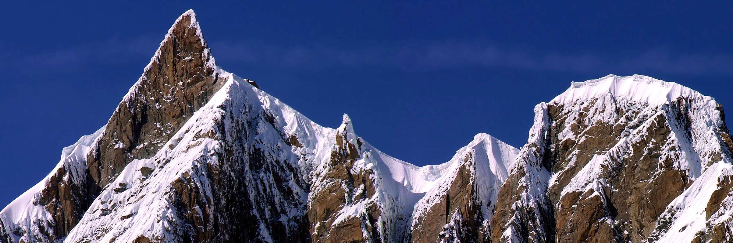
"Integral from Tacul to Maudit", by Antonio
Via b) - : dal centro del Versante Settentrionale, sopra le tre fasce glaciali e prima del lungo crepaccio diagonale, salire in diagonale e direttamente verso la Sommità, avvicinandosi così alla Via 1882 e percorrendo completamente la Parete Nord del Tacul. Variante da percorrere quando i crepacci della parte superiore rendono complicato oppure impossibile il tragitto verso la grande spalla.
B) - : analogamente nella salita del Mont Maudit dal Col du Mont Maudit abbandonare la "Normale" e con una digressione percorrere la cresta Nordovest, formata da rocce rotte, alcuni spuntoni, alternati a piccole creste di neve di forma affilata e con cornici rivolte a Nordest. Il primo percorso di questa via é quello di G.H. Morse con il celebre Emile Rey di Courmayeur, il 21 Agosto 1895. Calcolare sia per la variante al Tacul che per quella al Maudit mezza ora in più in salita ed un quarto di ora in discesa per entrambe con un aumento di orario supplettivo quindi di 1h'30 circa rispetto al percorso ordinario.
Route C Integral Traverse
This last type of crossing, at least among those chosen, provides a greater commitment from the technical point of view with difficulty definitely higher. In theory, the way to really "integrally" you should make the climb to the Mount Blanc of Tacul through the Via 1882 which, as we have already said, it is quite unwise if not impossible, and that involve risks are too high. We limit ourselves instead to the sector, which concerns the Mount Maudit giving other two alternative path which make it, so to say, "more integral":
1) - : instead of relying make the climb to the Col du Mount Maudit, attack, after the common initial part, the North Face directly the same as they did July 31th 1901 P. Cassan, P. Kornacker and H. Kuhn, the uphill has a degree of inclination which progressively varies from 35° to 45° in the lower part until the second crevasse which introduces to 135 meters of the terminal part, where the slopes reach even 50° and beyond. In the case of "verglass" or excessive width of the upper crevasse, should shoulder support on the neighbor 4.340 meters rejoining the Via of 2/3/4th July 1887 made by M. von Kuffner with the two Swiss Mountain Guides Alexander Burgener and Josef Furrer, together with a Porter Mountain, known precisely as "Via Kuffner". The tower is around the Summit to the right and go onto the Ridge to the Northwest and with this rope.
2) - : Tacul down from the ridge through the Southwest with the Via Morse -Rey 1895, without losing altitude, reaching the Col Maudit. Having exceeded the 4.187 meters at the end of the Aiguilles du Diable; reach an altitude 4.049 meters, and continuing on the ridge but keeping more on the French side and at a safe distance from the big snow drifts (which in 1946 fell on the Glacier du Géant French Mountain Guides Marcel Meysellier and Marcel Vuiller, for the failure of one of them), to reach the large shoulder 4.340 meters from the Via Masterman-Supersaxo 1898, whence the previous route. For both calculate at least 1h'00 more.
 |
Questo ultimo tipo di traversata, almeno tra quelli prescelti, prevede un maggiore impegno dal punto di vista tecnico con difficoltà sicuramente più elevate. In teoria per effettuare il percorso veramente in "modo integrale" si dovrebbe effettuare la salita al Mont Blanc du Tacul tramite la Via 1882, cosa che, come già abbiamo detto, é del tutto sconsigliabile se non addirittura impossibile e tale da comportare rischi troppo elevati. Ci limitiamo invece al settore concernente il Mont Maudit dando altre due alternative di percorso che lo rendono, per così dire, "maggiormente integrale":
1) - : invece di effettuare la salita appoggiandosi al Col du Mont Maudit, attaccare, dopo la parte iniziale comune, direttamente la Parete Nord dello stesso come fecero il 31 Luglio 1901 P. Cassan, P. Kornacker e ed H. Kuhn; la salita presenta un grado di inclinazione che progressivamente varia dai 35° ai 45° nella parte inferiore fino alla seconda crepaccia che introduce ai 135 metri della parte terminale, dove le pendenze raggiungono anche i 50° ed oltre. In caso di "verglass" o di eccessiva larghezza della crepaccia superiore, conviene appoggiare sull'attigua spalla 4.340 metri ricongiungendosi alla Via del 2/3/4 Luglio 1887 compiuta da M. von Kuffner con le due Guide svizzere Alexander Burgener e Josef Furrer, insieme ad un Portatore di Montagna, conosciuta, appunto, come "Via Kuffner". Il torrione sommitale lo si aggira a destra portandosi sulla Cresta Nordovest e con questa alla Cima.
2) - : dal Tacul scendere tramite la Cresta Sudovest con la Via Morse-Rey 1895 e, senza perdere dislivello, raggiungere il Col Maudit. dopo aver superato la quota 4.187 metri al termine delle Aiguilles du Diable; raggiungere la quota 4.049 metri e, continuando sul filo di cresta ma tenendosi più sul versante francese ed a debita distanza dalle grandi cornici di neve (dove nel 1946 precipitarono sul Glacier du Géant le Guide francesi Marcel Meysellier e Marcel Vuiller, per il cedimento di una di esse), pervenire alla grande spalla 4.340 metri tramite la Via Masterman-Supersaxo 1898, donde alla precedente via. Per entrambe calcolare almeno 1h'00 in più.
![]()
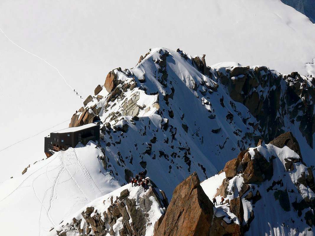
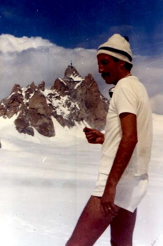
"Complete from West-northwest through ascent and "Bossons" descent, below Dôme du Gôuter", by Alberto Rampini
Come per ogni montagna, dopo la salita, bisogna effettuare la discesa e questa, a prescindere dal tipo più o meno facile, più o meno lungo, più o meno estenuante, é sempre guardata dall'alto con un atteggiamento di fatica e di sofferenza prossimo a venire. Non per nulla infatti molti incidenti e molte disgrazie si son verificate in una banale, o per lo meno meno difficile rispetto alla salita, discesa. Incominciando dalla cordata di Whymper al Cervino nel Luglio 1865, ma anche antecedentemente. La discesa costituisce un momento psicologico e fisico particolare: da una parte v'é l'appagamento per una meta ambita raggiunta e quindi l'attenzione tende inevitabilmente a decadere, dall'altra lo sforzo fisico incide sulla prestazione essendo le energie disponibili certamente non illimitate e di conseguenza l'organismo entra in una fase di recupero che farebbe sicuramente a meno d'un ulteriore sforzo. Quando poi aggiungiamo il fattore altitudine il quadro diventa ancor più completo. In breve tempo il corpo deve adattarsi a determinate situazioni fisiologiche ed in altrettanto breve deve rovesciare i valori acquisiti. Questo vale anche per il Monte Bianco che, con i suoi (4.811 metri), questo "giochino" lo ripropone sempre. Guai ad ignorarlo ...
Proponiamo le quattro discese fondamentali collimanti anche con le Vie Normali di salita, tenendo ben presente che in ognuna d'esse é certamento meglio non transitare, avendone la possibilità ma anche "organizzando l'orario" di percorrenza, nelle ore più calde:
1) - Rientrando al Col du Midi attraverso la via di salita ma, logicamente, passando al Col du Mont Maudit e "tagliando" sullo Spallone del Tacul. Possibilità d'indirizzarsi in Francia tramite la Funivia dall'Aiguille du Midi oppure in Italia con traversata del Glacier du Géant, salita al Col des Flambeaux e Rifugi Torino Nuovo e Vecchio.
BREVI, ma IMPORTANTI ANNOTAZIONI: evitare le ore più calde per il pericolo di caduta di seracchi sia sul Versante Settentrionale del Mont Maudit (tre anni orsono grande valanga con diverse vittime) che su quello del Tacul (numerose disgrazie nel corso degli anni anche in cordate con Guide, perché i seracchi non fanno differenze per nessuno). Eventuale piccola corda doppia alla grande crepaccia longitudinale superiore; in questo caso non lasciarsi attrarre da varianti più pericolose. Calcolare metà o due terzi del tempo di salita fino al Col du Midi, a seconda delle condizioni; da questo al Rifugio Torino identico tempo, se non qualcosa di più poiché la risalita al Col des Flambeaux in condizioni di stanchezza risulta sempre "ostica".
2) - Scendendo per quella che una volta era la "Via Normale francese", ovvero lungo il Glaciers de Bossons e verso il Rifugio dei Grands Mulets.
BREVI, ma IMPORTANTI ANNOTAZIONI: Via semplice e relativamente veloce, dove però non sempre si trova la via tracciata per diversi motivi (caduta di neve fresca, oppure sul ghiacciaio consunzione da parte del sole del tracciato); la medesima, dopo il Col du Dôme, diventa meno ripida con un pendio
(* * * attenzione nel tratto tra la Cima e la Capanna Vallot (4.362 m), poichè la cresta verso la Tournette, la Petite e la Grande Bosse può, a volte, trovarsi ghiacciata oppure con neve fresca; in questo ultimo caso si deve aver cura di "battere" continuamente con la piccozza sui ramponi, onde evitare l'accumulo ed il formarsi di pericolosi "sabots" o zoccoli di neve), che attraversa, scendendo a Nord del Col du Gouter, il Grand ed il Petit Plateau per raggiungere l'Hotellerie, la Jonction (2.642 m), Pierre à l'Echelle e, tramite sentiero, raggiungere Chamonix-Mont Blanc; se avete l'occasione d'incontrare una cordata con Guida seguitela, perché eviterete di sprecare tempo nella ricerca dei ponti sul ghiacciaio. Percorso molto esposto a grandi torri di ghiaccio, al di sotto delle quali é purtroppo obbligatoriamente transitare (il più rapidamente possibile; da 5 a 6 ore). Da la Jonction possibilità di scendere anche direttamente tramite il Ghiacciaio di Taconnay o Taconnaz sin sopra l'imbocco del Tunnel del Monte Bianco; questa scelta richiede totale visibilità, conoscenza del territorio ed ottima esperienza, altrimenti del tutto sconsigliabile.
3) - Attraversando all'Aiguille du Gôuter ed omonimo Rifugio, attualmente sicuramente la via maggiormente frequentata.
BREVI, ma IMPORTANTI ANNOTAZIONI: salire facilmente il Dôme du Gôuter per rendere veramente completa la traversata, oppure "tagliarlo" sotto sul Versante Meridionale raggiungendo l'Aiguille (3.863 m) ed il successivo Rifugio du Gôuter (3.817 m), Grand Couloir, les Rochers Rouges (3.270 m), Refuge de Tête Rousse (3.167 m), piccola traversata nella parte terminale del Glacier de Tete Rousse e con tracce seguite da sentiero. Dal rifugio, tramite sentiero, raggiungere la Stazione della Funivia (Tramway du Mont Blanc) del Nid d'Aigle (2.372 m). (4/5 ore; pericolo di caduta di pietre, nonostante che il tratto sia stato recentemente attrezzato; ma le pietre non vengono fermate dalle corde fisse, in un tratto dove generalmente si forma una "coda").
4) - Con discesa verso l'Italia e quindi in direzione del Rifugio Francesco Gonella, Ghiacciaio del Miage, Lago Combal e strada per Courmayeur attraverso la Val Veny.
BREVI, ma IMPORTANTI ANNOTAZIONI: dal Dôme, o subito al di sotto, volgere a Sudovest sulla cresta di confine in direzione del Col de Bionnassay (3.892 m), ma senza raggiungerlo; prima della quota 4.002 metri, girare a sinistra (Sud) e scendere sul Ghiacciaio del Dome , sotto la Calotte e la Tour des Aiguilles Grises (molto pericoloso nelle ore più calde con tutta una serie di crepacce collocate a "tambur battente" lungo l'asse trasversale) fino al Rifugio Francesco Gonella (3.072 m). Da questo tramite un promontorio roccioso scendere sul Glacier du Miage raggiungendo il "Jardin du Miage" in Val Veny, donde a Plan de Lognan (1.676 m; dalle 7 alle 9 ore).
![]()
"From East with fresh snowfall", by Antonio
1) - : invece di effettuare la salita appoggiandosi al Col du Mont Maudit, attaccare, dopo la parte iniziale comune, direttamente la Parete Nord dello stesso come fecero il 31 Luglio 1901 P. Cassan, P. Kornacker e ed H. Kuhn; la salita presenta un grado di inclinazione che progressivamente varia dai 35° ai 45° nella parte inferiore fino alla seconda crepaccia che introduce ai 135 metri della parte terminale, dove le pendenze raggiungono anche i 50° ed oltre. In caso di "verglass" o di eccessiva larghezza della crepaccia superiore, conviene appoggiare sull'attigua spalla 4.340 metri ricongiungendosi alla Via del 2/3/4 Luglio 1887 compiuta da M. von Kuffner con le due Guide svizzere Alexander Burgener e Josef Furrer, insieme ad un Portatore di Montagna, conosciuta, appunto, come "Via Kuffner". Il torrione sommitale lo si aggira a destra portandosi sulla Cresta Nordovest e con questa alla Cima.
2) - : dal Tacul scendere tramite la Cresta Sudovest con la Via Morse-Rey 1895 e, senza perdere dislivello, raggiungere il Col Maudit. dopo aver superato la quota 4.187 metri al termine delle Aiguilles du Diable; raggiungere la quota 4.049 metri e, continuando sul filo di cresta ma tenendosi più sul versante francese ed a debita distanza dalle grandi cornici di neve (dove nel 1946 precipitarono sul Glacier du Géant le Guide francesi Marcel Meysellier e Marcel Vuiller, per il cedimento di una di esse), pervenire alla grande spalla 4.340 metri tramite la Via Masterman-Supersaxo 1898, donde alla precedente via. Per entrambe calcolare almeno 1h'00 in più.
 |
 |
 |
 |
 |
Four ways to descend

As with any mountain, after the climb, you have to make the descent and this, regardless of the type more or less easy, more or less long, more or less exhausting, is always looked at from above with an attitude of toil and suffering neighbor to come. Not for nothing that in fact many accidents and many misfortunes occurred in a banal, or at least less difficult than the ascent, descent. Beginning with the Whymper rope on the Matterhorn in July 1865, but also prior. The descent is a particular physical and psychological moment: on the one hand there is the satisfaction for a destination reached and so the focus tends inevitably to decay, on the other physical exertion affects the performance of the available energy is certainly not unlimited and consequently the body enters a recovery phase that would definitely less than a further effort. When we add the factor altitude the "picture" becomes more complete. In a short time the body has to adapt to certain physiological situations and equally brief must overthrow the acquired values. This also applies to the Mount Blanc, with its (4.811 metres), this little "small game" brings him forever. Woe to ignore it ...
We propose four basic slopes coincide with the Ways Normal edge, bearing in mind that each of them is certainly better not pass, having the opportunity but also "planning time" traveling, during the hottest hours:
1) - Returning to the Col du Midi through the same route but, of course, going to the Col du Mont Maudit and "coupon" on the big Shoulder Tacul. Opportunity to contact in France by Cable car from the Aiguille du Midi or in Italy with the crossing of the Glacier du Géant, climb to the Col des Flambeaux and Shelters Turin New and Old.
SHORT, but IMPORTANT NOTES: avoid the hottest hours of the danger of falling seracs on both the North Slope of Mount Maudit (three years ago with several large avalanche victims) than on Tacul (many misfortunes over the years also roped in with Mountain Guides, because the seracs do not differentiate for none). Any small to big crevasse abseiling superior longitudinal, in this case not to be seduced by the most dangerous variants.
Calculate half or two thirds of the time to climb up to the Col du Midi, depending on the conditions, and from this to the Rifugio Torino same time, if not something more because the ascent to the Col des Flambeaux under conditions of fatigue is always "tricky".
2) - Going for what was once the "French Standard Route", or along the Glaciers de Bossons and to the Refuge of the Grands Mulets.
SHORT, but IMPORTANT NOTES: Via simple and relatively fast crossing where, however, do not always find the path marked out for various reasons (fresh snow fall, or wasting of the glacier from the sun's path), the same, after the Col du Dôme, becomes less steep with a slope
(* * * Attention in the stretch between the Summit and the Vallot Hut (4.362m), as the ridge towards the Tournette Rocks, Little and Great Bosse can sometimes be iced or with fresh snow, in the latter case, care must be taken to "beat" all the time with the ice ax on crampons, to avoid the accumulation and the formation of dangerous "sabots" or snow clogs)
, falling to North Col du Gôuter, the Grand and the Petit Plateau to reach the Hotellerie, the Jonction (2.642m), Pierre à l'Echelle, and through the path, reach Chamonix-Mount Blanc if you have the opportunity to meet a rope with Mountain Guide follow it, because you will avoid wasting time in search of the bridges over the glacier. Path very exposed to large ice towers, beneath of which is unfortunately compulsorily pass (as quickly as possible; from 5 to 6 hours). From the Jonction possibility to go directly through the glacier Taconnay or Taconnaz up above the entrance to the Mount Blanc Tunnel, this choice requires total visibility, experience and excellent knowledge of the area, otherwise completely inadvisable.
3) - Crossing the Aiguille du Gôuter and namesake Shelter, now surely the most frequented via.
SHORT, but IMPORTANT NOTES: easily climb the Dôme du Gôuter to make really complete the crossing, or "cut" under the South Side of reaching the Aiguille (3.863m) and the next Refuge du Gôuter (3.817m), Grand Couloir, les Rochers Rouges (3.270m), Refuge de Tete Rousse (3.167m), a small crossing in the terminal part of the Glacier de Tête Rousse and with traces followed by the path. From the hut, through the path, to reach the cable car station (Tramway du Mount Blanc) of the Nid d'Aigle (2.372m). (4/5 hours; danger of falling rocks, despite the fact that the stretch has been recently equipped, but the stones are not stopped by the fixed ropes, in a stretch where they generally form a "tail").
4) - With descent into Italy and then in the direction of the Refuge Francesco Gonella, Miage Glacier, Lake Combal and the road to Courmayeur through the Val Veny.
SHORT, but IMPORTANT NOTES: from the Dôme, or just below, the turn in the Southwest on the border ridge in the direction of the Col de Bionnassay (3.892m), but without reaching it; prior to 4.002 meters altitude, turn left (South) and get off on the Glacier Dôme, under the Calotte and the Tour des Aiguilles Grises (very dangerous during the hottest hours with a whole series of crevasses placed in "drum swing" along the transverse axis) to the Refuge Francesco Gonella (3.072m). From this through a rocky promontory off the Glacier du Miage reaching the "Miage Jardin" in Val Veny, whence in Plan de Lognan (1.676m; from 7 to 9 hours).
 |
Come per ogni montagna, dopo la salita, bisogna effettuare la discesa e questa, a prescindere dal tipo più o meno facile, più o meno lungo, più o meno estenuante, é sempre guardata dall'alto con un atteggiamento di fatica e di sofferenza prossimo a venire. Non per nulla infatti molti incidenti e molte disgrazie si son verificate in una banale, o per lo meno meno difficile rispetto alla salita, discesa. Incominciando dalla cordata di Whymper al Cervino nel Luglio 1865, ma anche antecedentemente. La discesa costituisce un momento psicologico e fisico particolare: da una parte v'é l'appagamento per una meta ambita raggiunta e quindi l'attenzione tende inevitabilmente a decadere, dall'altra lo sforzo fisico incide sulla prestazione essendo le energie disponibili certamente non illimitate e di conseguenza l'organismo entra in una fase di recupero che farebbe sicuramente a meno d'un ulteriore sforzo. Quando poi aggiungiamo il fattore altitudine il quadro diventa ancor più completo. In breve tempo il corpo deve adattarsi a determinate situazioni fisiologiche ed in altrettanto breve deve rovesciare i valori acquisiti. Questo vale anche per il Monte Bianco che, con i suoi (4.811 metri), questo "giochino" lo ripropone sempre. Guai ad ignorarlo ...
Proponiamo le quattro discese fondamentali collimanti anche con le Vie Normali di salita, tenendo ben presente che in ognuna d'esse é certamento meglio non transitare, avendone la possibilità ma anche "organizzando l'orario" di percorrenza, nelle ore più calde:
1) - Rientrando al Col du Midi attraverso la via di salita ma, logicamente, passando al Col du Mont Maudit e "tagliando" sullo Spallone del Tacul. Possibilità d'indirizzarsi in Francia tramite la Funivia dall'Aiguille du Midi oppure in Italia con traversata del Glacier du Géant, salita al Col des Flambeaux e Rifugi Torino Nuovo e Vecchio.
BREVI, ma IMPORTANTI ANNOTAZIONI: evitare le ore più calde per il pericolo di caduta di seracchi sia sul Versante Settentrionale del Mont Maudit (tre anni orsono grande valanga con diverse vittime) che su quello del Tacul (numerose disgrazie nel corso degli anni anche in cordate con Guide, perché i seracchi non fanno differenze per nessuno). Eventuale piccola corda doppia alla grande crepaccia longitudinale superiore; in questo caso non lasciarsi attrarre da varianti più pericolose. Calcolare metà o due terzi del tempo di salita fino al Col du Midi, a seconda delle condizioni; da questo al Rifugio Torino identico tempo, se non qualcosa di più poiché la risalita al Col des Flambeaux in condizioni di stanchezza risulta sempre "ostica".
2) - Scendendo per quella che una volta era la "Via Normale francese", ovvero lungo il Glaciers de Bossons e verso il Rifugio dei Grands Mulets.
BREVI, ma IMPORTANTI ANNOTAZIONI: Via semplice e relativamente veloce, dove però non sempre si trova la via tracciata per diversi motivi (caduta di neve fresca, oppure sul ghiacciaio consunzione da parte del sole del tracciato); la medesima, dopo il Col du Dôme, diventa meno ripida con un pendio
(* * * attenzione nel tratto tra la Cima e la Capanna Vallot (4.362 m), poichè la cresta verso la Tournette, la Petite e la Grande Bosse può, a volte, trovarsi ghiacciata oppure con neve fresca; in questo ultimo caso si deve aver cura di "battere" continuamente con la piccozza sui ramponi, onde evitare l'accumulo ed il formarsi di pericolosi "sabots" o zoccoli di neve), che attraversa, scendendo a Nord del Col du Gouter, il Grand ed il Petit Plateau per raggiungere l'Hotellerie, la Jonction (2.642 m), Pierre à l'Echelle e, tramite sentiero, raggiungere Chamonix-Mont Blanc; se avete l'occasione d'incontrare una cordata con Guida seguitela, perché eviterete di sprecare tempo nella ricerca dei ponti sul ghiacciaio. Percorso molto esposto a grandi torri di ghiaccio, al di sotto delle quali é purtroppo obbligatoriamente transitare (il più rapidamente possibile; da 5 a 6 ore). Da la Jonction possibilità di scendere anche direttamente tramite il Ghiacciaio di Taconnay o Taconnaz sin sopra l'imbocco del Tunnel del Monte Bianco; questa scelta richiede totale visibilità, conoscenza del territorio ed ottima esperienza, altrimenti del tutto sconsigliabile.
3) - Attraversando all'Aiguille du Gôuter ed omonimo Rifugio, attualmente sicuramente la via maggiormente frequentata.
BREVI, ma IMPORTANTI ANNOTAZIONI: salire facilmente il Dôme du Gôuter per rendere veramente completa la traversata, oppure "tagliarlo" sotto sul Versante Meridionale raggiungendo l'Aiguille (3.863 m) ed il successivo Rifugio du Gôuter (3.817 m), Grand Couloir, les Rochers Rouges (3.270 m), Refuge de Tête Rousse (3.167 m), piccola traversata nella parte terminale del Glacier de Tete Rousse e con tracce seguite da sentiero. Dal rifugio, tramite sentiero, raggiungere la Stazione della Funivia (Tramway du Mont Blanc) del Nid d'Aigle (2.372 m). (4/5 ore; pericolo di caduta di pietre, nonostante che il tratto sia stato recentemente attrezzato; ma le pietre non vengono fermate dalle corde fisse, in un tratto dove generalmente si forma una "coda").
4) - Con discesa verso l'Italia e quindi in direzione del Rifugio Francesco Gonella, Ghiacciaio del Miage, Lago Combal e strada per Courmayeur attraverso la Val Veny.
BREVI, ma IMPORTANTI ANNOTAZIONI: dal Dôme, o subito al di sotto, volgere a Sudovest sulla cresta di confine in direzione del Col de Bionnassay (3.892 m), ma senza raggiungerlo; prima della quota 4.002 metri, girare a sinistra (Sud) e scendere sul Ghiacciaio del Dome , sotto la Calotte e la Tour des Aiguilles Grises (molto pericoloso nelle ore più calde con tutta una serie di crepacce collocate a "tambur battente" lungo l'asse trasversale) fino al Rifugio Francesco Gonella (3.072 m). Da questo tramite un promontorio roccioso scendere sul Glacier du Miage raggiungendo il "Jardin du Miage" in Val Veny, donde a Plan de Lognan (1.676 m; dalle 7 alle 9 ore).
Conclusions
Surely the crossing from North to South and then from the South to West of the Mount Blanc remains a challenging test that can always reserve some surprises in view of the transformation of the ice and then the evolution of the path to follow, also the stability of the time it remains a requirement key to addressing this long path. The same becomes progressively more along with the variants described above and completely changes of perspective, from the point of view of the physical effort, starting from the two Torino Refuges. We have personally experienced this test with a short stop at the ruins of the Refuge des Cosmiques, then burned and that therefore do not allow for a proper camp, for which thing to midnight we were ready for departure, in practice without having made any recovery. They are two completely different climbs that will test the stamina. However, we also know of a climb in day of a trip from Torino of the C.A.I. Aosta at the beginning of the Sixties led by strong Mountain Guide Valpelline Angelo "Angelino" Bozzetti, after a night snowfall of nearly 50 inches tall. In a few, very few indeed, arrived with him in the Summit in this exhausting Marathon, opening the way through the snow. But it was "Angelino" Bozzetti ...
Other combinations of air enrich this crossing, which however becomes more partial, even if the same contemplate factors of higher difficulty and therefore fall outside the true concept of the same. They are usually the result of ascents on the Eastern Faces of the Mount Blanc du Tacul, the Col Maudit and Mount Maudit. Classic route that goes up to Maudit through its East-southeast Ridge that reaches 4.340 metres or big Shoulder "Via Kuffner", created by the same with the strong Swiss Mountain Guides Alexander Burgener and Joseph Furrer with an unknown Porter Mountain, in 2/3/4th July, 1887. But, in support of the above mentioned, the strong party composed by Lino Binel, Amilcare Crétier and Renato Chabod, after having completed the first ascent of the Southeast Wall of Mont Maudit along the "Via of the Red Pillar", in 1929, was forced to bivouac at a painful Rochers Rouges. From these he found salvation on the day following the storm crossing completely between the Northwest Slope of Mount Blanc to the West-northwest Ridge at the Petite Bosse then shelter in Vallot Hut. From "Diary Mountaineering" by Amilcare Crétier 1921-1933, Edit. Nuovi Sentieri, 1993: "At 4:30, the first dim glimmers of the day, veiled and made of "dark-colored" by the storm still raging, allow us to finally see his face. We are covered with ice. Glances our say, however, that we are ready for anything, and that the skin we sell dear. ... Let's start sleet. Intense cold. Fog and blizzard will not let us discern the right path. For 5 or 6 times to try to find a way down to the Vallot Cabine, but in vain ... In addition, the wind is so strong that he will throw us to the ground. It always comes back to the same starting point and here we dig a hole in the ice for shelter ... ".
He just wants to be an example of what can happen in these parts. Even for the most talented ...
 |
Sicuramente la traversata da Nord a Sud e poi dal Sud all'Ovest del Monte Bianco rimane una prova impegnativa tal che può riservare sempre delle sorprese in considerazione della trasformazione dei ghiacci e quindi dell'evoluzione del percorso da seguire; inoltre la stabilità del tempo rimane un requisito fondamentale nell'affrontare questo lungo tracciato. Lo stesso diventa progressivamente ancora più lungo con le varianti sopra descritte e cambia completamente di prospettiva, dal punto di vista dello sforzo fisico, partendo dal Rifugio Torino. Abbiamo sperimentato personalmente questa prova con una piccola sosta ai resti del Rifugio des Cosmiques, allora bruciato e tale quindi da non consentire un vero bivacco; per la quale cosa a Mezzanotte eravamo già pronti per la partenza, senza avere in pratica effettuato nessun recupero. Sono due ascensioni completamente diverse che mettono a dura prova le capacità di resistenza. Comunque sappiamo anche di una traversata in giornata dal Torino d'una gita del C.A.I. di Aosta agli inizi degli Anni Sessanta guidata dalla forte Guida della Valpelline Angelo "Angelino" Bozzetti, dopo una nevicata notturna di quasi 50 centimetri. In pochi, anzi pochissimi, arrivarono con lui in Cima in questa logorante Maratona aprendosi il varco tra la neve fresca. Ma era "Angelino" Bozzetti ...
Altre combinazioni di vie arricchiscono questa traversata, che però diventa maggiormente parziale, anche se le medesime contemplano fattori di più elevata difficoltà e quindi esulano dal concetto vero e proprio della stessa. In genere son frutto d'ascensioni sui versanti Orientali del Mont Blanc du Tacul, del Col Maudit e del Mont Maudit. Classica la via che sale al Maudit tramite la sua Cresta Est-sudest raggiungente la grande spalla 4340 metri o "Via Kuffner", realizzata dal medesimo con le forti Guide svizzere Alexander Burgener e Joseph Furrer con uno sconosciuto Portatore di Montagna, il 2/3/4/ Luglio 1887. Ma, a supporto di quanto sopra detto, la forte cordata composta da Lino Binel, Amilcare Crétier e Renato Chabod, dopo aver compiuto la prima salita della Parete Sudest del Mont Maudit lungo la "Via del Pilastro Rosso", nel 1929, fu costretta ad un penoso bivacco presso i Rochers Rouges. Da questi trovò la salvezza il giorno appresso traversando tra la tormenta completamente il Versante Nordovest del Monte Bianco fino alla Cresta Ovest-nordovest presso la Petite Bosse per poi ripararsi nella Vallot. Dal "Diario Alpinistico" di Amilcare Crétier 1921-1933, Ediz. Nuovi Sentieri, 1993: "Alle 4.30, i primi indistinti chiarori del giorno, velati e resi di "colore oscuro" dalla ancor imperversante bufera, ci permettono finalmente di vederci in viso. Siamo ricoperti di ghiaccio. Gli sguardi nostri dicono, però che siamo decisi a tutto, e che la pelle la vendiamo cara. Partiamo dunque ... Nevischio. Freddo intenso. La nebbia e la tormenta non ci lasciano discernere la via giusta. Per 5 o 6 volte tento di trovare una via per scendere alla Vallot, ma invano ... Inoltre il vento é così forte che ci butta a terra. Ritorniamo sempre allo stesso punto di partenza e qui scaviamo una fossa nel ghiaccio per ripararci ... ".
Vuole solo essere un esempio per cosa può capitare da queste parti. Anche pei più bravi ...
Da PD- a PD+; da PD+ a AD, a seconda delle varie vie.
Corda, piccozza, ramponi, elmetto, duvet, guanti, ghette, occhiali ed almeno due chiodi da ghiaccio e due moschettoni.
Altre combinazioni di vie arricchiscono questa traversata, che però diventa maggiormente parziale, anche se le medesime contemplano fattori di più elevata difficoltà e quindi esulano dal concetto vero e proprio della stessa. In genere son frutto d'ascensioni sui versanti Orientali del Mont Blanc du Tacul, del Col Maudit e del Mont Maudit. Classica la via che sale al Maudit tramite la sua Cresta Est-sudest raggiungente la grande spalla 4340 metri o "Via Kuffner", realizzata dal medesimo con le forti Guide svizzere Alexander Burgener e Joseph Furrer con uno sconosciuto Portatore di Montagna, il 2/3/4/ Luglio 1887. Ma, a supporto di quanto sopra detto, la forte cordata composta da Lino Binel, Amilcare Crétier e Renato Chabod, dopo aver compiuto la prima salita della Parete Sudest del Mont Maudit lungo la "Via del Pilastro Rosso", nel 1929, fu costretta ad un penoso bivacco presso i Rochers Rouges. Da questi trovò la salvezza il giorno appresso traversando tra la tormenta completamente il Versante Nordovest del Monte Bianco fino alla Cresta Ovest-nordovest presso la Petite Bosse per poi ripararsi nella Vallot. Dal "Diario Alpinistico" di Amilcare Crétier 1921-1933, Ediz. Nuovi Sentieri, 1993: "Alle 4.30, i primi indistinti chiarori del giorno, velati e resi di "colore oscuro" dalla ancor imperversante bufera, ci permettono finalmente di vederci in viso. Siamo ricoperti di ghiaccio. Gli sguardi nostri dicono, però che siamo decisi a tutto, e che la pelle la vendiamo cara. Partiamo dunque ... Nevischio. Freddo intenso. La nebbia e la tormenta non ci lasciano discernere la via giusta. Per 5 o 6 volte tento di trovare una via per scendere alla Vallot, ma invano ... Inoltre il vento é così forte che ci butta a terra. Ritorniamo sempre allo stesso punto di partenza e qui scaviamo una fossa nel ghiaccio per ripararci ... ".
Vuole solo essere un esempio per cosa può capitare da queste parti. Anche pei più bravi ...
Difficulties
From PD- to PD+; from PD+ to AD, depending on the various routes.Da PD- a PD+; da PD+ a AD, a seconda delle varie vie.
Essential Gear
Rope, ice ax, crampons, helmet, duvet, gloves, leggings or spats, goggles, and at least two ice screws and two carabiners.Corda, piccozza, ramponi, elmetto, duvet, guanti, ghette, occhiali ed almeno due chiodi da ghiaccio e due moschettoni.