Who am I to say Orrin Bonney was wrong? In Guide to the Wyoming Mountains and Wilderness Areas, he says this of Terrace Peak:
"Huge terraced peak NW above Granite Hot Springs with its E cliff bands sheering down to Granite Cr below. Probably routes of ascent would be via N or S stream-bearing gullies."
This all looks and sounds perfectly reasonable to anyone driving up Granite Creek Road or looking at a map. However, Bonney gives the elevation as 10,700', and that is where the problem occurs. Starting west from Granite Creek on a theoretical climb up the cliffs to the ridge above, one would first cross Point 10,420 (not marked-- interpolated elevation), then go over Point 10,623, followed by Point 10,654 , and then drop over 500' to a saddle before proceeding to Point 10,700, what Bonney identifies as Terrace Peak.
So in other words, what Bonney calls Terrace Peak actually should not be Terrace Peak and Point 10,654 should. And, having climbed both, I can say that both peaks have very different characters, and, if one were aiming just for one or the other, the easiest and most logical approach for each would not be the same. Perhaps today's prominence rules were not yet in effect when Bonney wrote his guide, but the apparent fact that he had not climbed the peak as of publication time suggests he made an error or was working with faulty information.
Thus, this page will cover Point 10,700 (Bonney's Terrace Peak), Point 10,654 (what really should be Terrace Peak), and a small but interesting peak in between them-- Point 10,405-- that does not have the prominence to be a ranked peak but is a worthwhile scramble along the way.
And in fact, the peaks are all so close together that climbing them together rather than in separate outings just makes a lot more sense. The attached route page will assist with that.
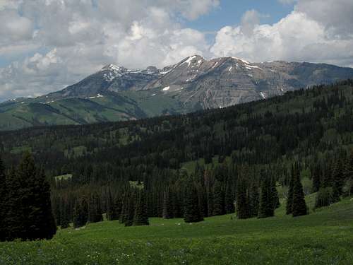
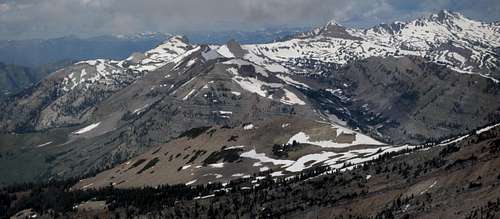
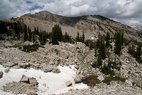
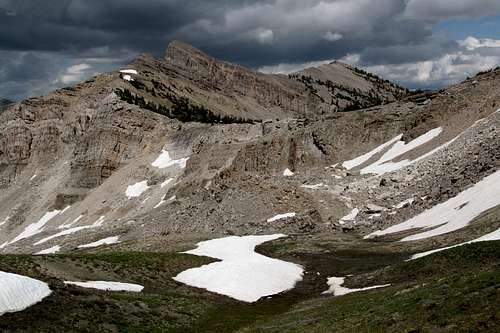
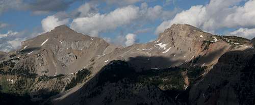
View of the peaks
View of the peaks
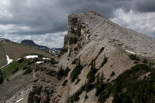
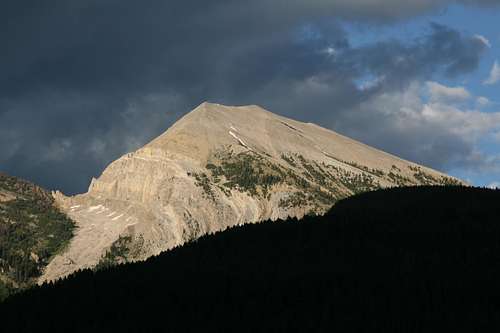
Point 10,700
Usually, I come up with a nickname for an unnamed peak I climb. It is not out of vanity; I don’t fancy that I have the authority to go around establishing names for peaks on my say-so alone. Instead, I do it to add a little extra character and appeal to the peak, and since I base the name on some outstanding or nearby geological feature, I feel it generates more attention and interest and helps a page user find or identify the peak.
After all, not many people are too likely to be seeking route information about Point 10,700 in a lightly used mountain range in a vast mountainous region. But this time, anything clever or sensible eludes me. There is no exceptionally remarkable rock feature at or near the summit. No lake is near. The headwaters of Boulder Creek are not far (though not directly below), but there are two other peaks much closer to Boulder Creek than this one is. There is a drainage on the north side of the summit, but it is unnamed.
Again, this is the peak Bonney refers to as "Terrace Peak" even though it really shouldn't be and should have its own name both because of its prominence and because of the difference in character between it and what should be Terrace Peak. Point 10,700 is one of several peaks of a long east-west ridge complex in the Gros Ventre Range. Most are nameless. Only two-- Pinnacle Peak and Gros Peak-- have names. 10,700’ probably is not even the true elevation; it seems to be an interpolated one based on the contour lines, as the summit is above the 10,680’ contour. The maximum reading I got with my GPS device was 10,673’, but I did not let it sit long enough to provide the most accurate reading that it could. By measures of vertical rise from saddles, though, the peak qualifies as a ranked one for those interested in that sort of thing. Steep mountainsides on the north and south sides of the peak drop to basins and drainages, vertical rise from the saddle to the west is about 500’, and vertical rise from the saddle to the east is also about 500’.
The summit has neither a cairn nor a register; it is a truly "wild" peak, and probably a handful of people, at the very most, visit it each year.
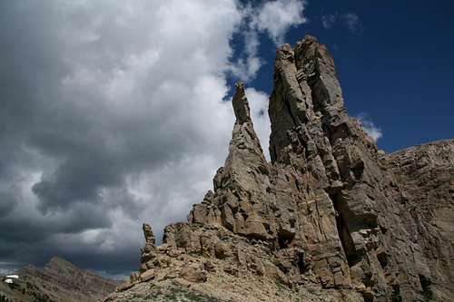
Point 10,405
Point 10,405 is another of several peaks on this very long ridge in the Gros Ventre Range. It is a small but striking peak, well into the wilderness, and almost never climbed. Without a doubt, it will satisfy those who seek isolation when they go to the mountains. This peak will not appear on any lists of ranked peaks; it only has about 250’ of vertical rise from the saddle between it and Point 10,654, and only about 200’ from the saddle between it and Point 10,700.
But it is hard to argue that the peak is just a bump along the way to one of those summits. Too much distance separates them. The peak clearly “stands out.” Point 10,700 is broad and gentle, but Point 10,405 is small, pointed, and steep; the former features grassy slopes leading to the summit while the latter is a mass of shattered limestone. The peak is more similar in character to Point 10,654, but from that second peak, Point 10,405 looks far away and totally separated.
“Pillar Peak” is my pet name for the peak. The title refers to a spectacular limestone pillar just west of the peak’s highpoint. Honestly, I first thought of “Pinnacle Peak,” but I knew that was already taken. So as I always say in such circumstances, if anyone knows of any official or unofficial name for this peak, please let me know and I will gladly make the necessary changes.
Point 10,654
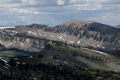
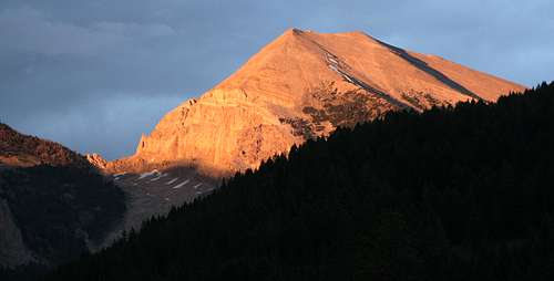
As one drives up Granite Creek Road in the vicinity of Granite Falls, a large, colorful, and interestingly shaped mountain comes into view to the northwest and dominates the scenery for a while. The eastern face features a series of cliff bands that give the face a somewhat terraced look. This is Terrace Peak, which consists of three different summits. The highest, and westernmost, is not visible from the road. This peak is what should be Terrace Peak in Bonney's Guide to the Wyoming Mountains and Wilderness Areas. On the USGS Crystal Peak quad, it is the mountain with three summits that are, from left to right, marked as 10,654, 10,623, and 10,400 (that last one is not marked as such on the map, but the 10,400 contour is the highest shown, so we might give it an interpolated elevation of 10,420’). They, along with nearby Point 10,321 on a spur ridge (a peak that just barely has the vertical rise to qualify as a ranked peak), are the easternmost peaks on a long east-west ridge complex that includes only two officially named summits-- Gros Peak and Pinnacle Peak. Terrace Peak does have the necessary vertical rise from all its saddles to make it a ranked peak. Whether it is or not I don’t know, as I am not much interested in that.
Named or not, and named correctly or not, this mountain is a worthy destination. The Gros Ventre Range is one of the least-traveled in the Greater Yellowstone Ecosystem, with no paved roads penetrating it and a trail system that, once a few miles from the nearest trailhead, often becomes lost in meadows filled with waist-high wildflowers. Most non-locals have never heard of the range, and the majority of users seem to be Jackson-area hikers and hunters. Although the trail that accesses Terrace Peak is one of the most popular in the range-- and that is not to say it is anywhere close to being busy-- it is highly unlikely that you will see another person up on the ridges and peaks up here; you probably won’t even see too many other people on the trail. The scenery is spectacular, of course. Gros Ventre cliffs and peaks that few people ever see are on display, and views extend to the northern Wyoming Range and all the way to the famous summits of the Tetons. There is a wild feel all around, and the mountain allows a sense of discovery and the feeling, even if only an illusion, that no one else has been there before. It is an intoxicating feel that makes you reluctant to leave. Given a nice day out here, you are bound to feel that you have found heaven. Like most Wyoming peaks, the mountain does not have a summit register, and like most unnamed Wyoming Peaks, it does not even have a summit cairn (and there is no real reason it needs them, either).
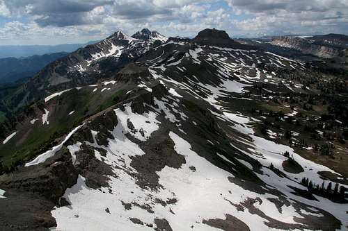
Views
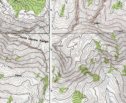
Topo Map
Getting There
Trailhead view
About 11 miles southeast of Hoback Junction, look for a signed road heading north into the Granite Creek Recreation Area. This gravel-and-dirt road, which can be a little rough but is still passable for most passenger vehicles, follows Granite Creek for 10 miles to Granite Hot Springs, a popular spa (admission fee required). Along the way there are spectacular views of Granite Creek and the Gros Ventre Range. 7.5 miles up the road, look for a spur that makes a bridged crossing of Granite Creek. Turn here and follow signs for 0.1 mi to a trailhead. Granite Highline Trail begins right across the road from the spur. In July 2010, there was no sign, but the trail was obvious to see. I actually parked a little off the road but not blocking it, just south of the trail’s beginning, to save myself a little walking and elevation gain.
Red tape, Camping, Links
No fees or permits. This is bear country, though, and habitat for both black and grizzly bears, so know your bear etiquette for both. Granite Creek Campground is a mile up the road from the trailhead. It is a large campground with running water and flush toilets. Sites cannot be reserved. The camping fee was $10 per night in July 2009. Dispersed camping is widely available, and backcountry camping is free (and no permit is needed). Bridger-Teton National Forest
Children refers to the set of objects that logically fall under a given object. For example, the
Aconcagua mountain page is a child of the 'Aconcagua Group' and the 'Seven Summits.' The
Aconcagua mountain itself has many routes, photos, and trip reports as children.
Parents refers to a larger category under which an object falls. For example, theAconcagua mountain page has the 'Aconcagua Group' and the 'Seven Summits' asparents and is a parent itself to many routes, photos, and Trip Reports.

 8862 Hits
 94.21% Score
 46 Votes