
-
 7005 Hits
-
 80.49% Score
-
 12 Votes
|
|
Mountain/Rock |
|---|---|
|
|
35.21326°N / 106.45353°W |
|
|
Hiking, Mountaineering, Trad Climbing |
|
|
Spring, Summer, Fall |
|
|
10010 ft / 3051 m |
|
|
Overview
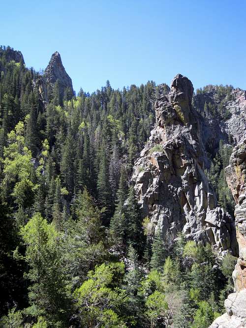
All routes to the summit are 5th class and are listed below.
North Face Direct 5.5
Rocky Racoon 5.7
Arrow Heads and Pitons 5.7+
Smoke on the Horizon 5.11b
Getting There

Take the Tijeras exit off of I-40 east of Albuquerque and drive north on Highway 14 to San Antonito. A left onto Road 536 (Sandia Crest Road) will take you an additional 14 miles to the Sandia Crest Parking Lot.
The Hike:
Park and walk to the trailhead on the north side of parking lot to the right/east of the radio towers. Once on the North Crest Trail, travel past the meadow overlooking the road and enter the forested wilderness.
At the first fork (3-way), take a hard right. Walk south along the trail for 5 minutes to the next 3-way fork where you will take the right branch that travels downhill rather than continuing to traverse south like the other 2 trails.
Continue to a large meadow with aspen, in the middle of which a faint trail travels south, over and beyond a fallen aspen (20+ inches in diameter). This trail meanders into the descent gully from which the Chimney is easily seen. The trail eventually turns right at the base of the gully. About another 100 feet, a side trail branches off to the left towards the base of the Chimney.
Red Tape
Protected as part of the Sandia District of the Cibola National Forest and the Sandia Mountains Wilderness Area, The Chimney has several restrictions. No motorized vehicles or mountain bikes are allowed on the trails and a $3 parking fee is required at all trailheads within the national forest or wilderness. They now accept National Parks Passes in the parking areas.Camping
There are no campgrounds on the mountain but camping is allowed as long as fires are not made. However, all climbs are done within a day so camping is unnecessary for most people.When to Climb
The rock is climbable spring through early winter. The best period is between April and September, which is true for most peaks in New Mexico. Afternoon thunderstorms are common on this mountain, more frequently during the spring, summer, and fall. Due to the dry air, altitude, and intense sun that drain you of water it is important to pack plenty of it (a liter or 2 per person is good).
Mountain Conditions
For mountain conditions you can take one of the following links.Sandia Peak Ski Area Weather
National Weather Service Forecast
It is also possible to e-mail, call, or mail the district ranger of the Sandia Mountains. His e-mail is jcandrew@fs.fed.us, his address is 11776 Highway 337, Tijeras, New Mexico USA 87059-8619, and his phone numbers are (505) 281-3304 [voice] and (505) 281-1176 [fax].
tarol - Jun 23, 2012 9:40 pm - Voted 10/10
National Park Passesold terminology - they are now Interagency Passes :)