
-
 2930 Hits
-
 71.06% Score
-
 1 Votes
|
|
Mountain/Rock |
|---|---|
|
|
39.74406°N / 106.30613°W |
|
|
Scrambling |
|
|
Summer, Fall |
|
|
12865 ft / 3921 m |
|
|
Overview
"The Elephant" is located right in the center of the Black Creek valley and offers sweeping views of some of the most prominent peaks and ridges of the Gore Range - Eagle' Nest, Mount Powell, Ripsaw Ridge, Peak L, Guyselman Mountain, Peak K, Peak R, Peak Z....
When climbing the Northeast Ridge heading to the summit the origin of the (unofficial) name becomes obvious. The summit block and its side ridges resemble indeed a bulky elephant head with floppy ears and a massive trunk.
Its location in the almost trailless Black Creek Drainage, rising between the wild valleys of the North and South Black Creek, guarantees absolute solitude.
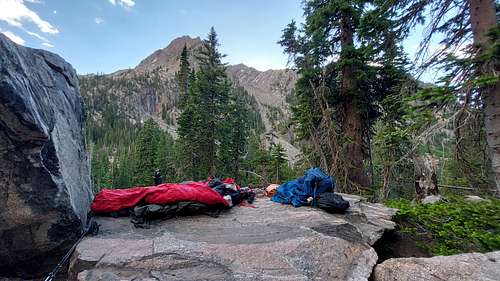 Bivouac - The Elephant
Getting There
Black Creek Drainage is the wildest and most isolated valley system of the entire Gore Range.
It has the distiction of being the only drainage system within the Gore Range not being accessible by any offically marked trail.
Only the most upper and lower part of the drainage are accessible by two unmarked trails not shown on any map.
Your choice of trailhead is determined by what route you intend to take up to the summit.
Piney Lake Trailhead:
Piney Lake Trailhead provides access to an unmarked trail up to Kneeknocker Pass. From here the North and Southwest Ridge can be attained via Bubble Lake.
Exit I-70 at Exit 176 (Vail) and head west on the North Frontage Road for 1 mile to Red Sandstone Road, turn right and follow the paved road for 3/4 miles. The paved road switches to the right and a graded dirt/gravel road (FS 700) continues on from this point (signed). Road is fine for 2WD vehicles, but ride gets a bit bumpy towards the end. Follow the road for 11 miles to the parking area just before the entrance to Piney River Ranch.
Brush Creek Trailhead:
Brush Creek Trailhead provides access to an unmarked trail leading right underneath the Northeast Ridge of The Elephant.
From Silverthorne, drive north on Hwy 9 16 miles and turn left on the Heeney Creek Road (CR 30.).
Any vehicle without High Clearance: park at the Kansas Gulch-Grandview Cemetery - 0.7 miles to the right after turn off. Don't miss the marker with the interesting (and tragic) history of the first settlers in this area.
With High Clearance: turn sharp left 0.6 miles after turn off onto FS 1695. After the first switchbacks you will run into three wide holes in the road next to each other - each at least one foot deep (2023). This is section is impassable for any sedan and prob most SUVs.If you try you may get stuck and/or lose your oil pan /exhaust in the process of it. Brush Creek road is not maintained; this section will only get worse in the years to come.
The next first half mile is a steep, rocky and narrow dirt road with only enough space for one car. Meeting a car on one of the steep ascents may put you into a tricky spot. Any rain will turn the road into a slippery mess. The road relents after the initial climb but there are still several deep ruts to be mastered until you reach the Brush Creek Trailhead.
Notice: FS 1696 is closed for vehicle traffic between Nov 20th and June 23rd - the gate right at the beginning of the forest road will be locked.
Route
The Elephant offers multiple access routes via its North, Northeast and Southwest Ridge as well as its South Face.
Red Tape
You will be hiking almost entirely within the Eagle's Nest Wilderness. Please keep this place wild and abide to all wilderness regulations.
When to Climb
Best to climb between late spring to late fall. Avalanche danger and / or deep snow will make both access routes inaccessible in winter and early spring.
Camping
Brush Creek access:
The meadow at the end of the trail leading to the South Black Creek Valley and the meadows between The Elephant and Peak I make excellent camp sites.
Piney Lake access:
Bubble Lake is an excellent camp site - keep in mind to camp at least 100 ft from any water body.
External Links