
-
 5031 Hits
-
 77.48% Score
-
 8 Votes
|
|
List |
|---|---|
|
|
Overview
The Aosta Valley (Italy) is one of the most famous and beautiful mountainous countries in the world. It holds many impressive mountains like Monte Bianco, Monte Rosa, Monte Cervino (Matterhorn) and Gran Paradiso. But there are also many 3.500 meters peaks which are well known all over the world: For example the impressive Aiguille Noire de Peuterey and almost as impressive; Herbetet, Aiguille de Trélatête, Grivola, Mont Vélan, Becca di Luseney, Punta Tersiva and many others.
La Valle d'Aosta (Italia), è una delle più famose e belle regioni di montagna del mondo. Contiene molte montagne imponenti come il Monte Bianco, il Monte Rosa, il Monte Cervino (Matterhorn) e il Gran Paradiso. Esistono però anche moltissime vette di oltre 3.500 metri molto conosciute dagli alpinisti come l'imponente Aiguille Noire de Peuterey, l'Herbetet, l'Aiguille de Trélatête, la Grivola, il Mont Vélan, la Becca di Luseney, la Punta Tersiva e molte altre.
MAPS:
Ferret Valley
|
First ascent: A. Hess, O. Leitz and Laurent Croux, (Jul 22th, 1898).
Difficulty: PD.
Difference in height: About 165m from ref. Torino.
Refuge: Rifugio Torino (3.375m). Places when open: 190 places.
Ascent time: 1,30-2,00 hours.
Descent: Along the ascent route.
Equipment: High mountain equipment: including rope, helmet, frontal torch, ice axe, and crampons.
|
|
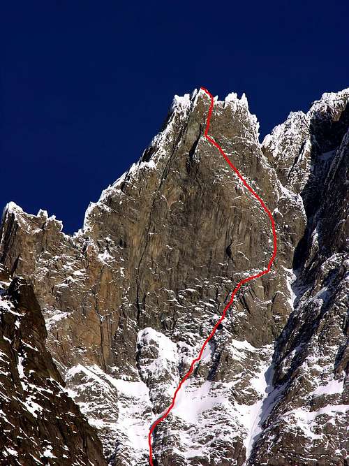
First ascent: Enrico Peyronel and Walter Bonatti, (Jul 17th, 1952).
Difficulty: TD+.
Difference in height: About 2.403m from Planpincieux.
Refuge: Rifugio Gabriele Boccalatte-Mario Piolti (2.804m). Places when open: 25. Winter hut: 25 places.
Ascent time: 12,00-12,30 hours.
Descent: From normal route
Equipment: High mountain equipment: including rope, helmet, frontal torch, nuts, friends, ice axe, and crampons.
|
|
First ascent: Albert Guyard, Henri Devouassoud and Auguste Cupelin, (Sep 23th,1876). Difficulty: AD.
Difference in height: -
Refuge: Bivacco fisso Giusto Gervasutti (2.835m), 10 places.
Ascent time: 8,00-9,30 hours.
Descent: Along the ascent route.
Equipment: High mountain equipment: including rope, helmet, frontal torch, ice axe, and crampons.
|
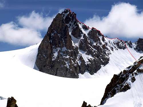
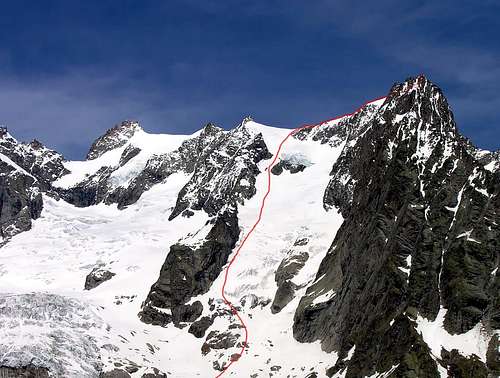
 Pointe des Hirondelles 3.519m Pointe des Hirondelles 3.519mFirst ascent: -
Difficulty: -
Difference in height: -
Refuge: -
Ascent time: -
Descent: -
Equipment: High mountain equipment: including rope, helmet, frontal torch, ice axe, and crampons.
|
|
First ascent: -
Difficulty: -
Difference in height: -
Refuge: -
Ascent time: -
Descent: -
Equipment: High mountain equipment: including rope, helmet, frontal torch, ice axe, and crampons.
|
|
First ascent: J. A. G. Marshall, T. S. Kennedy, Johann Fischer and Julien Grande, (Jul 14th, 1872).
Difficulty: AD+.
Difference in height: About 2.120m (from La Vachey Village).
Refuge: Bivacco fisso Giusto Gervasutti (2.835m), 10 places.
Ascent time: 8,00-9,00 hours.
Descent: Along the ascent route.
Equipment: High mountain equipment: including rope, helmet, frontal torch, ice axe, and crampons.
|
|
AIGUILLE DE TALÈFRE 3.730m
First ascent: -
Difficulty: -
Difference in height: -
Refuge: -
Ascent time: -
Descent: -
Equipment: High mountain equipment: including rope, helmet, frontal torch, ice axe, and crampons.
|
|
First ascent -
Difficulty: -
Difference in height: -
Refuge: -
Ascent time: -
Descent: -
Equipment: High mountain equipment: including rope, helmet, frontal torch, ice axe, and crampons.
|
|
First ascent: -
Difficulty: -
Difference in height: -
Refuge: -
Ascent time: -
Descent: -
Equipment: High mountain equipment: including rope, helmet, frontal torch, ice axe, and crampons.
|
|
First ascent: -
Difficulty: -
Difference in height: -
Refuge: -
Ascent time: -
Descent: -
Equipment: High mountain equipment: including rope, helmet, frontal torch, ice axe, and crampons.
|
|
First ascent: -
Difficulty: -
Difference in height: -
Refuge: -
Ascent time: -
Descent: -
Equipment: High mountain equipment: including rope, helmet, frontal torch, ice axe, and crampons.
|
|
First ascent: Edward Whymper, Antony Adams Reilly, Michel Croz, Henry Charlet and Michel Payot, (Jul 09th, 1864).
Difficulty: PD+.
Difference in height: About 2.050m (from Arnouva Village).
Refuge: Bivacco fisso Cesare Fiorio (2.800m), 20 places.
Ascent time: 6,00-7,00 hours.
Descent: Along the ascent route.
Equipment: High mountain equipment: including rope, helmet, frontal torch, ice axe, and crampons.
|
|
MONT GRAPILLON 3.576m
First ascent: -
Difficulty: -
Difference in height: -
Refuge: -
Ascent time: -
Descent: -
Equipment: High mountain equipment: including rope, helmet, frontal torch, ice axe, and crampons.
|
Refuges Telephone Numbers
- Rifugio CESARE DALMAZZI (2.598 meters) Tel. 0165-869098
- Rifugio GABRIELE BOCCALATTE-MARIO PIOLTI (2.806 meters) Tel. 0165-844070
- Rifugio ELENA (2.061 meters) Tel. 0165-844688
- Rifugio WALTER BONATTI (2.025 meters) Tel. 0165-869055
- Rifugio GIORGIO BERTONE (1.996 meters) Tel. 0165-844612
Books and Maps
BOOKS:- "Guida delle Alpi Occidentali", di Giovanni Bobba e Luigi Vaccarone C.A.I. Sezione di Torino Volume II (parte II), 25 Maggio 1896.
- "Guida dei Monti d'Italia-Monte Bianco" (Vol. I°) di Gino Buscaini-Club Alpino Italiano/Turing Club Italiano, 1994 (in Italian).
- "I Rifugi della Valle d'Aosta" di Stefano Ardito, Ed. Guide iter, Febbraio 2003.
- "A piedi in Valle d'Aosta" (Vol. 1), di Stefano Ardito, Ed. Guide iter, Giugno 2003.
- "80 itinerari di Escursionismo Alpinismo e Sci Alpinismo in Valle d'Aosta", di Osvaldo Cardellina, Ed. Musumeci, Giugno 1977 (in Italian); seconda Ed. Luglio 1981; terza Ed. Luglio 1984; (in French), prima Ed. Febbraio 1978; seconda Ed. Marzo 1980.
 |
 |
 |
 |
 |
- Kompass "Massiccio del Monte Bianco Valle d'Aosta Sentieri e Rifugi" Carta turistica 1:50.000.
- I.G.C. Istituto Geografico Centrale Torino "Massiccio del Monte Bianco" (n° 4), Torino, 1998 1:50.000.
- I.G.C. Istituto Geografico Centrale Torino "Monte Bianco-Courmayeur-Chamonix-La Thuile" (n° 107), 1:25.000.
- Kompass "Massiccio del Monte Bianco Valle d'Aosta" Carta escursioni, bike e sci alpinismo 1:50.000.
- L'Escursionista "Monte Bianco Courmayeur" (n° 1) Edizioni Rimini 2004 1:25.000.
- IGN Carte de randonnée CHAMONIX - MASSIF DU MONT BLANC 3630 OT 1:25.000.
- Edizioni Tabacco "Mont Blanc" Udine, 1978 1:50.000.
- Studio F.M.B. Bologna 1988 "Monte Bianco-Mont Blanc" 1:50.000.
- IGN institut géographique national genoble mont-blanc parc national de la vanoise (n° 53), 1:100.000.
 |
 |
 |
 |
Important Information
- REGIONE AUTONOMA VALLE D'AOSTA the official site.
- FONDAZIONE MONTAGNA SICURA Villa Cameron, località Villard de la Palud n° 1 Courmayeur (AO) Tel: 39 0165 897602 - Fax: 39 0165 897647.
- Società Guide Alpine Courmayeur www.Guidecourmayeur.com - Strada Villair n° 2 - 11013 Courmayeur (Aosta) Italy - Tel. +390165842064 Fax. +390165842357 - P.I. 01022640070
- A.I.NE.VA. (Associazione Interregionale Neve e Valanghe).
Useful Numbers
- Protezione Civile Valdostana località Aeroporto n° 7/A Saint Christophe (Ao) Tel. 0165-238222.
- Bollettino Meteo (weather info) Tel. 0165-44113.
- Unità Operativa di Soccorso Sanitario Tel. 118.