-
 42312 Hits
-
 96.75% Score
-
 62 Votes
|
|
Area/Range |
|---|---|
|
|
45.46784°N / 7.10266°E |
|
|
Hiking, Mountaineering, Trad Climbing, Ice Climbing, Scrambling, Skiing |
|
|
Spring, Summer, Winter |
|
|
12306 ft / 3751 m |
|
|
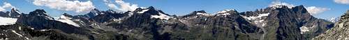
Graius montium series
est omnis divisa in partes quinque ... Alpi Graie, Graian Alps, Graius Mons ... they say (Varrone & Cornelio Nepote) that their name comes after Hercules Graius (greek) that, according to the legend, crossed this range of mountains passing through the Pass now named Piccolo San Bernardo ...
North of the Occitania (Alpi Cozie), starting from the Colle del Moncenisio and ending to the Col Ferret, there is a big range, fairly little known but by French and Western Italian mountaneers, skimountaneers and hunters.
This range hasn't a linear structure, here is where the tectonic activity that made the Alps had the top: we have a main watershed that hosts mountains that are much smaller than the ones that make up the chained groups, so, to better speak about this range we can/must divide the whole range in 5 parts, very different from each other as for kind of rock and shape:
- 1 - a SW range, divided from the main watershed by the important Val d'Isère: the Vanoise Group with summits high up to 3800+ meters
- 2 - a SE range, on the main watershed: see section A
- 3 - a E range, out of the watershed, starting from the Colle del Nivolet (2612m), a big ridge is the southern border of the main alpin valley (the Aosta valley) and hosts the big, famous group of Gran Paradiso, with its minor subgroups of Grivola and Emilius-Tersiva
- 4 - a NW range, on the main watershed: see section B
- 5 - a N range: from Col de la Seigne to Col du Grand Ferret
Here mountains enter in another dimension with the Mont Blanc group that I think should be considered as a "world apart"
just to avoid useless duplicate we will speak here only about the sections belonging to the main watershed (and, of course, their secondary ridges) that share the same kind of geological structure, shape and kind of climbing possibilities
Most of the summits belonging to these areas are well known for their long, difficult and wonderful ski-mountaneering routes: a real university of ski-mountaneering.
Getting There
Main accesses are from
- ITALY
Torino - for the Southern range
Aosta - for the Northern range - FRANCE
Val d'Isère - for the Western side
A - SE range - Alpi Graie Meridionali
This is the Piemonte part of the range
From Moncenisio to Passo della Galisia (watershed) and Nivolet pass
Starting from the Moncenisio the ridge is well defined in its first part.
The first important summit is the Rocciamelone (3538m) then the Croce Rossa (3566m), the Punta d'Arnas or Ouille d'Arbaron (3563m), the most important summit of this range, the Uja di Ciamarella (3676m) with its neighbour Bessanese (3592m) and Albaron di Savoia or Pointe d'Albaron (3627 m), then, after the small group of Mulinet (3444m) and the remarkable group of the Levanne (3619m) the ridge goes "down" to the Passo di Galisia (3000m)
On the Italian side, two main areas, digged by the main north-piemontese rivers tributary to the PO river, give access to the main and secundary ridges:
- the Stura valleys - known as Valli di Lanzo made by three main valleys Valle di Viù, Val d’Ala and Val Grande and a small and less know valley Valle del Tesso.
- the Orco valley
Here you can find a part of the Alps that have resisted at the attack of Urbanization, like cement and asphalt, where the mountains has kept intact its wild and sharp fascination.
accesses:
You can arrive at the mountains of Lanzo's Valleys in less than an our by Car from Turin or even less time from the airport of Turin (Caselle).
Local small towns and villages:
Lanzo Torinese (515m), Germagnano (485m), Traves (628m), Pessinetto (590m), Mezzenile (654m), Ceres (713m)
Getting There by car:
Fom Turin,motorway A55 exit Venaria Reale follow indications for Lanzo Torinese (30 km from Turin).
On the French side the main ridge is delimited (and accessible) from the road of the Val d'Arc (descending from the Col de l'Iseran to Lanslebourg)
| the Valli di Lanzo: the Val di Viù, the Val di Ala and the Val Grande | the Val dell'Orco, starting from Pont Canavese |
| Valli di Lanzo - Map | Valle dell'Orco - Map |
detailed info for accesses come from SP member p-mike, thanks!
A1 - Val di Viù
the southernmost of the Valli di Lanzo
divided to the south from Val di Susa by a small range containing some summits worth to be mentioned but without alpinistic importance: the M.Palon (2985m), the P.Lunella (2772m) and the Monte Civrari (with his three summits Punta della Croce 2234 m, Punta Imperatoria 2302 m and Torretta del Prete 2264 m).
And divided from the Val d'Ala by a ridge starting (from W) with an important mountain Torre di Ovarda (3075m) and going down with the Punta Barale, the Monte Servin (3108m), the Cima d'Autur (3021m), the Punta Lucellina, the Monte Ciorneva and the Rocca Moròs.
accesses :
Viù (774m), Lemie (957m), Usseglio (1250m)
Go on through Germagnano and turn left crossing the river, proceed entering in Val di Viù, continue passing Viù, Lemie, Usseglio and Margone and reach Malciaussia lake (1810m) where the road ends (80 km from Turin).
Malciaussià is the starting point for
- the Rifugio Tazzetti, for Rocciamelone (3538 m) (that can be climbed, faster and easier from Rifugio Cà d'Asti)and Pointe du Ribon (3527 m).
- Monte Lera (3355 m)
- Punta Sulè (3384 m)
Usseglio is the starting point for: - the Rifugio Cibario, for Croce Rossa (3566m), Monte Lera (3355 m), Punta Sulè (3384 m) and the Pointe d'Arnas or Ouille d'Arbaron (3563m).
the Pointe des Lauses Noires (3378m) on the ridge dividing the Val di Viù from the Val d'Ala, is a fine and not much difficult ski-mountaneering goal
A2 - Val di Ala
the central one
divided from the Val Grande by a ridge starting with the Ghicet di Sea (2.735) pass between Val d'Ala and Val Grande and containing the Punta Rossa di Sea (2908m) than the most important mountain, the Uia di Mondrone (2964m) and ending, toward East with some less important mountains, the Monte Carro (2316m) and the Monte Dubia (2463m) and finish just before Ceres with a small summit Santa Cristina (1340m) with the sanctuary on the top.
accesses :
Ala di Stura (1075m), Balme (1432m)
Go on through Germagnano and Ceres, here you enter in Val d’ Ala, continue passing Ala di Stura and Balme and reach Pian della Mussa (1830m) where the road ends (78 km from Turin).
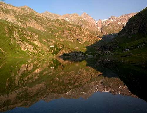
Pian della Mussa (rifugio Città di Cirié) is the starting point for the Rifugio Gastaldi and for the important summits of Bessanese (3604 m),Uja di Ciamarella (3676 m), Albaron di Savoia (3627 m), Punta Maria (3400m), Punta Chalanson (3466m), Piccola Ciamarella (3537m) and Albaron di Sea (3262 m).![Val D'Ala - Bessanese from Pian della Mussa]()
Val D'Ala - Bessanese from Pian della Mussa
Some very fine ski-mountaneering routes are available for skilled and trained climbers :
Cima Autour (3021m) starting from Balme (1446m)
Punta Maria (3400m) starting from Pian della Mussa (1800m)
Albaron di Savoia (3627m) starting from Pian della Mussa (1800m)
Uja di Ciamarella (3676m) starting from Pian della Mussa (1800m)
From Balme it is possible to reach - the Bivacco Gandolfo, starting point for the: Torre d'Ovarda (3075 m), Monte Servin (3108 m) and Punta Barale (3005 m).
- the Bivacco Molino, starting point for the: Uia di Mondrone (2964 m), Cima Leitosa Occidentale (2870 m) and Punta Rossa di Sea (2908 m).
All this mountains can also be climbed directly from Balme in one day.
A3 - Val Grande
the northernmost one
divided from the Valle dell'Orco by a very long ridge, starting from the Levanne Group - Levanna Orientale (3555 m) and finish with Cima Mares (1.654 m).
Main summits are Cima della Piccola (2870 m), Barrouard (2865m), Corno Bianco (2883m and 2891m), Monte Morion (2839 m), Cima della Crocetta (2824 m), Punta Fertà (2780 m), Monte Bellagarda (2901 m), the most important Monte Unghiasse (2939m), Monte Gran Bernardè (2747 m), Monte Bessun (2908 m), Monte Tovo Piccolo (2729 m), Cima Giardonera (2784 m), Punta Pian Spigo (2520 m), Monte Bellavarda (2345 m), Punta Marsè (2317 m), La Rossa (2319 m), Monte Vaccarezza (2203 m), Uia di Corio (2042 m), Monte Soglio (1971 m) and Cima Mares (1.654 m).
accesses :
Val Grande
Cantoira (749m), Chialamberto (851m), Groscavallo (1106m)
Go on through Germagnano and Pessinetto, then turn right and enter in Val Grande, continue passing Cantoira, Chialamberto and Groscavallo and reach Forno Alpi Graie (1220m) where the road ends (60 km from Turin).
Forno Alpi Graie is the starting point for - the Rifugio Daviso, for Levanna Orientale (3555m), Punta Girard (3262m), Punta Clavarino (3260 m), Punta di Mezzenile (3429m), Punta Martellot (3452m)
- the old Rifugio Ferreri, out of service.
- the Bivacco Rivero, destroyed for the third time in 2006 by an avalanche, it was the starting point for Uja della Gura (3364 m), Punta di Mezzenile (3429m), Dent d'Ecot (3402 m) and the Cima Monfret (3373m).
![Val Grande]()
Val Grande
From Forno Alpi Graie, the (minor) Sea valley (it is 12 km long from Forno Alpi Graie to Colle di Sea and more or less 2000 m of gradient!), give access to the Bivacco Soardi -Fassero (2297m) that is the best starting point for the Uia Ciamarella (N wall) (3676m), Albaron di Sea (3262 m), Punta Tonini (3324 m), the Pointe Bonneval (3325m) and the Punta Francesetti (3410m), very fine and serious ski-mountaneering goals.
accesses :
Valle del Tesso
Coassolo Torinese (732m), Monastero di Lanzo (804m)
From Lanzo Torinese following the indications after a bridge turn right for Coassolo Torinese, or turn left for Monastero di Lanzo, continue and reach Chiaves (1049m) where the asphalt road ends (45 km from Turin), here a country road proceed to Monastero lake (1992m).
Monastero lake is the starting point for: Monte Bellavarda (2345 m), Punta Marsè (2317 m), La Rossa (2319 m), Punta Gias Vej (2179 m), Punta dell'Aggia (2253 m).
Coassolo Torinese, or Monastero di Lanzo are the starting point for: Monte Vaccarezza (2203 m), Cima dell'Angiolino (2.168 m).
A4 - Valle dell'Orco
the valley bordering, at his southern side, the Gran Paradiso Group -
![Gran Paradiso & Levanne]()
Gran Paradiso & Levanne
divided from the Val Grande by a long ridge, starting from the Levanne Group and hosting few important summits like the Corno Bianco (2883m) and the Monte Unghiasse (2939m)
the road, starting from Cuorgné, passing through Pont Canavese, Locana, Noasca and Ceresole, arrives up to the Colle del Nivolet (2612m) that is, geographically, the western border of the Gran Paradiso Group
Ceresole Reale is, as for the Alpi Graie, the real alpinistic center of the valley: herefrom start all the approaches to the main mountain of the right side of the valley : the Levanne Group -
![W border of Val dell'Orco]()
W border of Val dell'Orco
on the main ridge, north of Levanne, some interesting summits host very fine ski-mountaneering routes (of course they can be also hiked in summer) : - Cima del Carro (3326m)
- Grande Aiguille Rousse (3482m)
- Punta Basei (3338m)
Valle Orco has some important lateral valleys, belonging to the Gran Paradiso Group (thanks to Andrea for additions) :
Valle Soana (ramified then in Forzo and Campiglia valleys)
It borders the Champorcher Valley to the north and Valchiusella to the east.
starts from Pont Canavese; the most important villages are Ronco Canavese, Valprato, Campiglia Soana and Piamprato.
The most important mountains are: Punta delle Sengie (3408m), Torre Lavina (3308m),Punta Gialin (3270m), Monveso di Forzo (3222m), Rosa dei Banchi (3164m).
Valle di Ribordone
starts from Sparone; Monte Colombo (2848m) is the highest mountain.
Valle di Piantonetto
starts from Rosone and it is accessible by car up to the dam of Teleccio lake.
famous due to the big walls and ridges of its mountains (mainly of excellent granite), it's often quite crowded of rock-climbers.
The most known mountains are: Torre del Gran San Pietro (3692m), Becca di Gay (3621m), Becco di Valsoera (3369m), Becco Meridionale della Tribolazione (3360m).
B - NW range - Alpi Graie Settentrionali
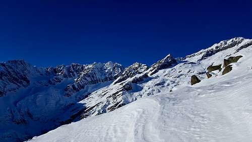
This is the Val d'Aosta part of the range, the most wonderful site of the whole Alps for serious and fine ski-mountaneering activity
From Nivolet pass to Col de la Seigne
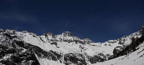
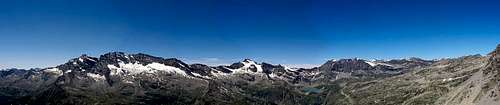
From the Galisia pass, toward North, the main ridge, through a fine series of mountains, the Punta Galisia (3346m), the Roc de Bassagne (3222m), the Punta Calabre (3350m), the Punta Tsanteleina (3601m), the Becca della Traversiere (3337m), the Grande Sassiere (3751m), the Punta di Nantcruet (3510m), the Punta Plattes des Chamois (3610m), the Becca di Suessa (3420m), the Mont Ormelune (3278m), the Chateau Blanc (3408m) ends, after the Group of Rutor (3486m) to the Colle of Piccolo San Bernardo (2188m)
accesses :
from North (Aosta) along the Valsavarenche, the Valgrisenche, the Val di Rhemes and the Val de La Thuile (P.S.Bernardo),
from West (France) along the Val d'Isère
B1 - Valsavarenche
The easternmost valley entering, from Val d'Aosta, into the Graie Alps range
This valley is the western border of Gran Paradiso Group
The access road starts from Villeneuve (some 10 km W of Aosta) and ends to the Col del Nivolet.
Almost all the hikers and climbers entering in this valley only turn their gaze to the left side, toward the Herbetet, the Gran Paradiso, the Ciarforon, the Monciair ecc.
Refuges and Bivouacs - Rifugio Federico Chabod (2750m) useful ONLY for the Gran Paradiso Group
main ascensions: Gran Paradiso (4061m), Becca di Montandayné per il colle di Bonney (3587m), Herbetet (3778m), Piccolo Paradiso (3926m).
excursions: Bivacco Leonessa (2910m), Colle di Bonney (3587m), rifugio Vittorio Emanuele II (2730m), rifugio Vittorio Sella (2584m), Colle Lauson (3296m), Colle Neyron (3414m), Bivacco Sberna (3414m). - Rifugio Vittorio Emanuele II (2730m) useful ONLY for the Gran Paradiso Group
main ascensions: Gran Paradiso (4061m), Tresenta (3609m), Ciarforon (3642m), Becca di Monciair (3544m), Denti del Broglio (3454m).
excursions: Rifugio Chabod (2750m), Rifugio Pontese (2200m), Colle del Gran Paradiso (3345m),Colle dei Becchi (2990m), Rifugi Città di Chivasso (2604m) e Savoia (2532m), colle di punta Foura (3187m), Bivacco Ivrea 2270m). - Rifugi Città di Chivasso e Savoia (2604m and 2532m) useful ALSO for the main watershed ridge of Graie Alps
main ascensions: Punta Basey (3338m),Mont Taou Blanc (3438m),Gran Vaudala (3272m), Punta Violetta (3031m), Cima dell'Arolley (3075m), Punta Foura (3411m).
excursions: Rifugio Benevolo (2285m), Colle della Nivoletta (3130m), Colle Rosset (3023m), Colle Leynir (3084m), Rifugio Vittorio Emanuele II (2730m). - Bivouac Sebastiano e Renzo Sberna (3414m) useful ONLY for the Gran Paradiso Group
main ascensions: Herbetet (3778m), Becca di Montandaynè (3838m), Piccolo Paradiso (3926m), Gran Paradiso (4061m) crossing from Herbetet.
Lakes
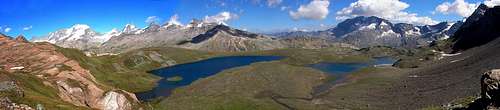
Laghi di Djouan (2516m - 2520m), Lac Noir (2666m), Lago delle Mèyes (2589m), Laghi del Nivolet (2526m - 2534m), Laghi dei tre Becchi (2722m - 2727m - 2728m), Lago Leynir (2746m).
Valsavarenche is crossed by the altavia n° 2
On the eastern side, a not small ridge, coming down from the Punta della Galisia (3346m), hosts some very fine (especially for ski-mountaneering) summits : - Gran Vaudala (3250m)
- Cima di Percia (3212m)
- Punta di Bioula (3414m)
the only problem is the big difference in elevation due to the absolute lack of Refuges or Bivouacs ... so that one must start directly from the bottom of the valley : Valsavaranche, Eau Rousse or Pont
B2 - Val di Rhêmes
A fine valley between the watershed (S) the Valsavarenche (E) and the Val Grisenche (W) -
![the W watershed of Val di Rhemes]()
the W watershed of Val di Rhemes
The access road starts from Villeneuve (some 10 km W of Aosta) and, passing through Introd and Rhêmes St. George end at Rhêmes Notre Dame
Refuges and Bivouacs - Rifugio Gian Federico Benevolo (2285m)
main ascensions: Granta Parei (3387m), Punta Tsanteleina (3601m), Punta Calabre (3445m), Punta Galisia (3346m), Punta Basei (3338m), Gran Vaudalla (3250m), Becca della Traversière (3337m), Becca Tsambeina (3162m).
excursions: Rifugio de Prariond (2324m) Francia, Rifugi Savoia-Chivasso (3534m 2604m), Colle della Nivoletta (3130m), Rifugio Mario Bezzi (2284m).
Lakes
Laghi di Changier (2450m 2643m), Lago di Pellaud (1810m), Lago di Golettaz (2795m).
Val di Rhêmes is crossed by the altavia n° 2
watershed :
Punta Galisia (3346m)
Punta Calabre (3445m)
Punta Tsanteleina (3601m)
Granta Parei (3387m)
eastern ridge (dividing from the Valsavarenche)
Cima di Entrelor (3430m)
Monte Teu Blanc (3438m)
B3 - Valgrisenche
A fine valley between the watershed (W) the Val di Rhêmes (E) and the Val di La Thuile (S)
The access road starts from Arvier-Leverogne (some 15km W of Aosta) and goes through Planaval to Valgrisenche, a road, not always open, leads, along the lake, to Surier
Refuges and Bivouacs - Rifugio Chalet de L'épée (2370m)
main ascensions: Becca di Tey (3186m), Punta di Rabuigne (3261m), Monte Forciaz (3244m), Cima del Bouc (3107m), Grande Rousse (3607m).
excursions: Colle di Cossuna (2885m), Becca dei quattro venti (2640m), Colle di Giasson (3154m), Colle di Feluma (3001m) Bivacco Ravelli (2860m). - Rifugio Mario Bezzi (2284m)
main ascensions: Grande Traversière (3496m), Aiguille de la Grande Sassière (3751m) per il colle omonimo, Punta Bassac nord (3387m), Truc Blanc (3405m), Becca della Traversière (3337m), Punta Plattes des Chamois (3610m), Becca di Giasson (3202m).
excursions: Rifugio Chalet de L'épée (2370m), Colle di Bassac (3153m), Lago di San Martino (2770m), Colle Vaudet (2830m), Lago di Vuert (2623m). - Bivouac Luigi Ravelli (2860m)
main ascensions: Grande Rousse (3607m), Punta di Rabuigne (3261m), Cima di San Martino (3363m), Punta Tina (3523m), Punta di Barmaverin (3472m), Cima di Fos (3447m), Becca di Giasson (3202m).
Lakes
Lago di Lolair (1184m), Lago di Fond (2438m), Lago artificiale di Beauregard (1710m), Laghi di Morion (2810m 2815m), Lago di San Grato (2462m), Lago di San Martino (2770m).
Valgrisenche is crossed by the altavia n° 2
watershed
Aiguille de la Grande Sassiere (3747m)
Punta Sassiere (3672m)
Punta Plattes des Chamois (3610m)
Becca di Suessa (3420m)
Monte Ormelune (3278m)
Becca du Lac (3396m)
Chateau Blanc (3408)
eastern ridge (dividing from the Val di Rhêmes)
Gran Traversiere (3496m)
Grande Rousse (3607m)
Becca di Tos (3302m)
Truc Blanc (3405m)
Punta di Luetta or Tzaboc (3214m)B4 - Val di La Thuile
The last valley of the Graie Alps, between the Val Grisenche (S), the watershed (W) and the Val Veni (N)
The access road starts from Pre St. Didier and. passing through La Thuile, arrives to the Piccolo San Bernardo pass, joyning to the Val d'Isere
Refuges and Bivouacs - Rifugio Alberto Deffeyes (2494m)
main ascensions:
Monte Monchette (3043m), Testa del Rutor (3486m), Grand Assaly (3174m), Mont Valaisan (2892m), Cresta Thuilette (2420m), Château Blanc (3408m), Becca du Lac (3396m), Doravidi (3439m), Becca Bianca (3261m), Becca Nera (3263m), Monte Paramont (3301m).
excursions: Colle di Planaval (3016m), Colle del Rutor (3373m), Colle Loydon (2945m).
Lakes
Lago d'Arpy (2066m), Lago di Pietra Rossa (2553), Laghi di Bella Comba (2373m 2374m), Laghi del Tachuy (2513m 2549m), Lago Glacier (2143m), Lago Azzurro (2428m), Lago del Rutor (2387m), Lago Verde (2605m), Laghi des Ussellettes (2762m 2770m).
Val di La Thuile is crossed by the altavia n° 2
watershed
Grand Assaly (3174m)
Mont Valaisan (2892m)
south-eastern ridge (dividing from the Val Grisenche)
Becca Bianca (3261m)
Rutor group (3486m)
Monte Paramont (3301m)
Monte Colmet (3024m)
Becca Pugnenta (2827m)
B5 - Miravidi group
North of Piccolo San Bernardo a small range, with some fine easy mountains, leads to the Col de la Seigne (2516m)
main ascensions:
Monte Berio Blanc (3252m), Punta Leschaud (3127m), Pointe des Ouillons (3110m), Miravidi (3066m), Monte Quille (3099m), Mont Favre (2967m), Tête des Jeunes (2785m), Tête des Vieux (2978m), Punta Fornet (3067m).
Lakes
Lago de Plate (2422m), Lago Verney (2088m), Lago Verney superiore (2294m), Lago Tormotta (2846m).
Is crossed by the altavia n° 2
Miravidi (3066m)
Punta Leschaud (3127m)
Monte Quille (3099m)
Berio Blanc (3252m)