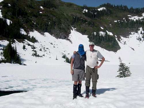
Trail Report July 7 thru July 14, 2012
We love the Olympics because the park is remote from the main population centers around Seattle and Portland. The
Olympic National Park has three distinct ecosystems; seashore, rainforest, and alpine, which can be visited by a traveler, who if willing to pay the price of a bit of effort and discomfort, will find one's self truly alone to enjoy nature at her finest.
The High Divide is a ridge running west to east, dividing the approaches to the Olympics from the north from the Hoh River Valley.
Just to the east is the secluded Bailey Range, rarely visited only by the most serious backcountry adventurers. In sharp contrast, many hikers have enjoyed scaling the Divide with views of the Seven Lakes Basin to the north and Mount Olympus chain and its glaciers to the south. In late summer and fall the High Divide loop (~ 18 miles) can be accomplished on a long day from the trailhead on the Sol Duc River, making this set of trails well-traveled and popular.
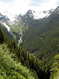
The Hoh River Valley opens to the Pacific Ocean on the west. It gathers storms from its mouth concentrating the precipitation either in the temperate rainforest or at higher elevations on the delicate alpine. The snow pack is extraordinary. Because of the large annual snowfall, the glaciers on Olympus exist at a low elevation allowing a team to ascend without the typical acclimation required for higher climbs found in most mountaineering adventures.
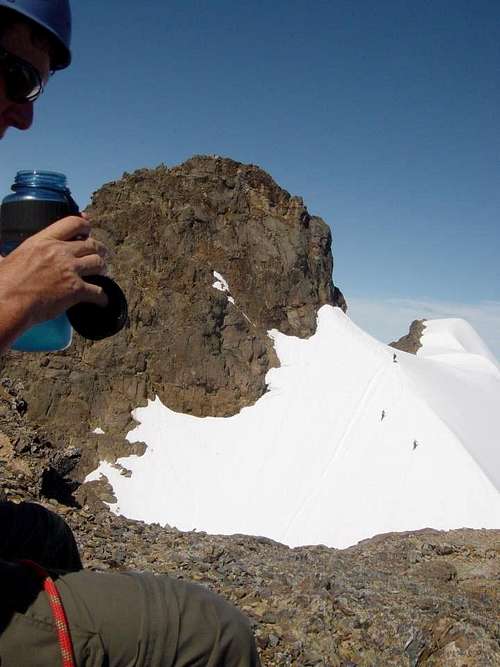
In 2012, a record snow fall and a late spring left the High Divide covered in snow into mid-July, when we planned our trip. We were one of the first that year to scale the Divide and descend into the Hoh River Valley. If you plan your trip early in the season, the details of this part of the trip report may be helpful to you. The climb to the High Divide and the traverse on the snow fields around Bogachiel demands some skill. The conditions required us to be able to route-find using the land features and a map and compass as a guide. We were advised particular care should be taken to avoid the snow bridges cut out by the melt water running below the snow pack in hundreds of small seasonal tributaries. In July this year, above 4000 feet elevation, the trail was fully obscured beneath several feet of snow. Outside of a few fresh tracks and one set of lost sunglasses, we did not see evidence of another human being for two full days on the High Divide.
Most teams scale Olympus by hiking into and out of the Hoh River Valley, starting at the Hoh Rainforest Visitor Center. We wanted to practice our snow techniques before summit day and also make one practice climb, in order to strengthen our legs and lungs, so we chose to enter the Hoh Valley from the High Divide.
The second goal of the trip was to climb to Glacier Meadows and summit Mount Olympus. In researching other trail reports on this website and www.peakbagger.com, the ascent can be quite different in early and late season requiring different level of skills. Also with such a rapid snow melt the conditions change constantly. A summit route, easily traveled one day, can be blocked the next. Also the weather can be variable and the summit is often inaccessible due to visibility. The cool thing is that each trip is a new adventure and the beta obtained in advance is limited in its value, giving each mountaineer the opportunity to practice "first ascent" skills.
In mid-July this year, the conditions were optimal for summit parties. The approach trail all the way from the Hoh River to Glacier Meadows was snow free, thereby allowing us to spend most of our energy on the summit bid. After weeks of rain in the region, we found ideal sunny conditions for summit day with the Blue Glacier fully snow covered and the approach already well worn by several teams. If you plan an ascent of Olympus check out the summit block pictures in the body of the report. We shared the summit approach with two other two person teams; some newly found Canadian friends, quite accomplished backcountry sojouners, and two locals, who will go unnamed, because of our exhaustion numbed memories.
The hike out, the full length of the Hoh River Trail, matches its reputation for a relentless slog. Unfortunately the beauty of the rainforest, with its old growth trees and hanging moss, was overshadowed by our sore muscles and desire to be free of the trail. We did take a few brief water breaks which allowed us to examine the epiphytes and the huge sitka spruce and western hemlock.
Here is our journal:
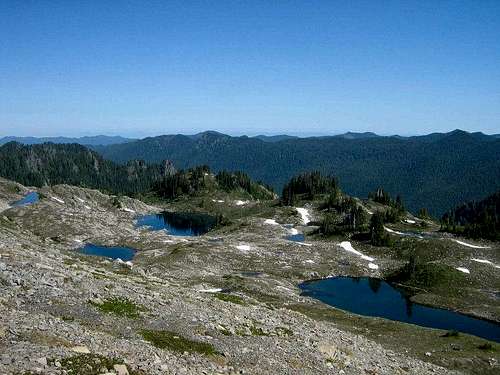
The High Divide and Hoh Lake
July 7th - Saturday approach Jon and Teri (our church buddies from PA now living in Gig Harbor) picked us up at the airport hotel.
We traveled from SEATAC, to the Edmonds - Kingston Ferry, to Port Angeles. We had an amazing brunch at
Chestnut Cottage and then obtained trail permits, bear boxes, and snow conditions from the
Wilderness Information Center.
Departed the Sol Duc Trail head at 2 PM at approximately 2000 feet elevation.
![Crossing the Sol Duc]() The Sol Duc crossing - still no snow
The Sol Duc crossing - still no snowHiked up to 2700 feet past Sol Duc Falls. Passed John and Matt coming down who had intended to hike the full High Divide loop but had to turn around because they did not have crampons and ice axes. They said they made it past the traverse around Bogachiel Peak and turned around because of steep snow fields somewhere near Lunch Lake at 11 AM the same day. It was about 4 PM so they had reversed their hike and descended in about five hours. Matt had a “run in” with a tree on the ridge and his face was deeply scratched in several places. We made camp about an hour later and dinner was fresh hamburgers in tortillas.
July 8th - Sunday. Departed 8:30 AM after a sumptuous meal of fresh eggs. Hit snow at 4000 feet just after the switchbacks above the Sol Duc River Bridge (crossing north to south). Route finding was difficult as the terrain flattens out on the ridge and the trail leaves Bridge Creek.
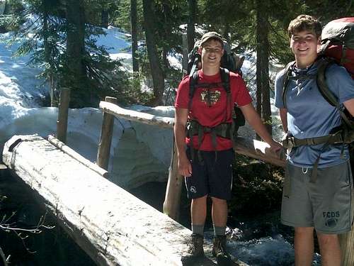
![Crossing Bridge Creek]() Bridge Creek crossing
Bridge Creek crossingWe could not decide whether the most prominent peak to our east was Cat Peak or Mount Fitzhenry, so we could not take a compass heading to give us our exact location. When leading, Dad fell through one surprising snow bridge into a hidden small shallow tributary – about a 24 inch fall which bruised Dad’s shin. It was probably good this happened because it made us much more cautious. We ended up following a set of tracks we thought was Matt and John’s, but actually turned out to be from another two hikers, a father-son team climbing Cat Peak at the start of the Bailey Range. They had left pink survey tape on the trees. We were thankful because by following these markers we did find the trail on occasion. We met them descending just below Sol Duc Park camp. “First contact with any other people in 41 hours”, the father said as we approached.
He was an experienced climber, and they advised, since the bridge was out at Sol Duc Park over Bridge Creek, that we should follow their tracks until the snow bowl below the ridge and then traverse west to intersect the High Divide from there. They were pulling their tape as they retreated. They identified the prominent peak as Mount Fitzhenry, so we were well oriented. We put on our crampons there, since the snow was continuous.
We had lunch at the Sol Duc Park ranger tent about noon. The tent had been shoveled out. We signed into the log left there by the ranger, since no park personnel had yet moved in. No wonder, since no one was camping in any camp sites and it appeared the snow was about three to five feet deep. The bridge location across Bridge Creek was flagged; but the bridge was indeed missing. We followed the route west of the creek, which put us west of another large branch. As it turned out this branch was not emanating from Heart Lake, but from the snow bowl west. Like idiots, we forgot our sun screen in the car at the trailhead when we repacked. So we baked in the sun which was directly to our face. Later John ended up with second degree burns on his face, because of a reaction with some other medicine he was taking. Dad and Evan were red in the face, neck and arms, even after using several sticks of chapstick (spf 15) on our skin.
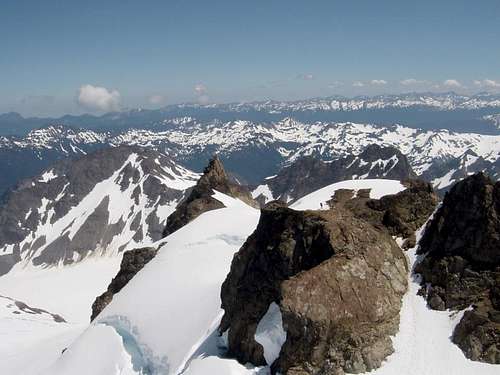
We watered up at the last side tributary, since that would be the last melt we expected to see as we would be traveling the ridge into the next day. We attained the ridge with phenomenal views of Mount Olympus and the Blue Glacier about 2 PM. Compass headings from Mount Olympus gave us exact trail locations. We identified Heart Lake from above. The edges of the ice covered lake were discernible.
![Unnamed Image]() Check out the snow bridge
Check out the snow bridgeWe ascended the ridge into the Seven Lakes Basin area to the north on our right. We picked up John and Matt’s tracks. Camp that night was on the ridge on snow with views of both Olympus and the Seven Lakes Basin. We were at about 5000 feet elevation. We melted snow for water. Dinner was red beans and rice with fresh sun dried tomatoes and summer sausage. We had cell service, so we texted Katie since it was her birthday. We were also able to give the family a short report on our progress.
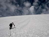
Monday July 9. We left around 8 AM and ascended the ridge east toward Bogachiel Peak. The first part of the trip took us above a huge avalanche chute on the Hoh River Valley side. We initially made good time, although the climb along the ridge was strenuous. We found the trail as it descended from the ridge around the south side of Bogachiel. We traversed across the snow field below and onto the short saddle, following fresh tracks on occasion. Because John and Matt did not have crampons or ice axes, they had scaled the top edge of some of the snow fields to stay on hard ground. We were not sure where the trail split for the descent to Lunch Lake, but we lost their tracks in the snow permanently there.
![Evam at Hoh Lake]()
Evan at Hoh Lake
That is where the route finding got difficult. All the subtle bowls and ridges come together at this location so the terrain was hard to correlate to the map. When the trail traverses through trees there are no tree blazes and it is anyone's best guess how the trail descends hidden below several feet of snow.
![Our camp at Hoh Creek Falls]() Camp at Hoh Falls
Camp at Hoh FallsFrom where we estimated to be the trail split, leaving the High Divide Loop "following" the direction of the trail to Hoh Lake, we traversed several hundred yards to 50 feet of exposed trail abutting a small rock outcropping and then continued our traverse to a ridge. We thought from there we should oversee the Hoh Lake Basin. We looked over the ridge line and were surprised to find another snow field in a large bowl – but curiously no Hoh Lake. It should have been very close.
We lost the trail. We did not want to get "blocked in" low so we decided to climb the ridge about 300 feet in elevation to find a 200 foot drop down a sheer rock abutment blocking our way. We retreated down the ridge a ways and bushwhacked down to the snow field on the west side. While in that next bowl, we saw a black bear running across the snow, about 100 yards off, not concerned with us at all. At least he knew where he was going! Still heading west, we finished the traverse to the next intersecting ridge. Looking back east where we had been, we could see the trail had descended the last ridge and skirted it at the bottom. We chose the hardest way.
Over that ridge, we found the Hoh Lake Basin, finally, and saw where the trail cut the ridge and descended traversing north. Evan scouted a route south, where we could see the snow fields reached the basin floor. We should have followed his advice to go that way, but we were distracted, since the trail seemed to descend the other way. We followed the trail and lost it beneath the snow within a hundred yards, still expecting to find evidence of a trail switchback to the south. No luck again. We found a snow field on the far north edge of the basin and descended it only to find heavy trees and then a sharp drop down some cliffs blocking our way. Along the way we found a set of snow sunglasses on the snow. We thought that strange, because there were no tracks at that point. However the glasses were found on top of the snow, not at all melted in, indicating they had been recently lost from above.
We were left with two options; to climb the snow field we had just descended, or follow Evan south traversing the tops of the cliffs, well below the ridge, through very heavy brush. We listened to Evan and he finally found the snow fields, that he had seen earlier, which took us down to Hoh Lake.
All the route finding, struggling in the brush, useless climbing, and odd traverses, drained us of a good bit of energy and about 4 hours of time. It took us 7 hours to make about 3 trail miles that day, although we had traveled much farther. We decided to make camp below Hoh Lake near the start of the Hoh Creek Falls and try the descent into the Hoh River Valley the next day.
Our spirits improved as the camp was amazing. We found a fairly level piece of exposed ground above a large tree for cooking. Elevation was about 4500 feet. We put the tents on the snow. We were able to level out two platforms with our ice axes. Since we were a long way from an established camp, we stripped some fresh evergreen branches from a few trees for insulation below the tent floor. The sleeping was warm and comfortable. Dinner was beef stroganoff with some fresh shiitake mushrooms and three berry cobbler from Mountain House. Good food and a comfortable camp can improve the sourest spirits.
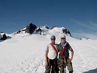
![The Baker s at Hoh Lake]() The boys at Hoh Lake. See the ridge we descended upper right
The boys at Hoh Lake. See the ridge we descended upper rightA short tale about the snow sunglasses. When we exited at Hoh Rain Forest Visitor center, at the end of our trip, we heard the story of the German hiker who hiked up on the High Divide from the Lunch Lake Trail intending to complete the full 18 mile loop in one day.
![Finding the trail on the descent from Hoh Lake]() Finding the trail
Finding the trailSince he did not need an overnight trail permit he was not aware of the snow conditions and how impossible the hike was to complete in a single day. He got lost. Instead of completing the traverse below Bogachiel, going the opposite way from us, he ended up taking the descent into the Hoh Lake Basin. He must have ended up on the same useless snowfield as we did the day before we were there. He bivvied out a cold night at Hoh Lake thinking he was in the Seven Lakes Basin. He descended into the Hoh Valley down Hoh Creek the next day, with his only thought that he needed to drop down to get out of the snow. When the rangers found him at the Olympus Guard Station he looked like he had been “attacked by several cats” from fighting the same brush as we did. Actually, his story made our frustrating day on Monday seem very tame in comparison. His snow glasses came in handy, as we used them as a spare on summit day, when Evan forgot his at camp.
Tuesday July 10th. We broke camp with the intent to stay on the west side of Hoh Creek. Our thought was that if we missed the trail east of the creek, we may not be able to ford (east to west), since the snow melt was very heavy and the creek was running deep. The map seemed to indicate that the trail crossed Hoh Creek above the falls so we spent about 30 minutes, before putting on our backpacks, trying to find the exposed trail at the edge of the creek. We were unsuccessful, so we were left with no choice but to bushwhack down the cliffs on the west side of the creek. We again fought brush, wind downed trees, and very damp slippery ground from the melting snow. After climbing and then descending one game trail along the top edge of the cliffs, without any progress down, we finally opted to rappel down a wet portion of the cliffs. Later one ranger said that this was the first he had heard of a backpacking group doing that.
We found the trail crossing the creek below the falls (oops-of course that makes sense now), but it was impossible to follow the trail more than 20 feet. The creek takes a sharp turn east so the compass heading of 250 degrees we needed to follow put us moving away from the creek. It seemed all wrong. We skirted a side tributary trusting our compass, and then the trail appeared from under the snow at the top of the tributary crossing.
We had spent two hours route-finding and the thought of another four miles of hacking our way through brush and then entering the dense rainforest was weighing heavily on us. We needed to find the trail or our visit to Mount Olympus might be in peril. Our goal was to make 13 miles that day, and by 10:30 AM we had only come ½ a mile. Evan said he never wanted to see snow again. We all felt better and started putting some miles behind us.
The trail traverses until the descending ridge meets it. Once on the top of the ridge, the views of the Hoh River are spectacular and the switchbacks were not that bad through the windblown area where the trail has recently been re-routed.
The trail met Hoh Creek again in the rainforest at about 1000 feet elevation and we stopped for lunch there. We made camp at 12.4, which is right before the serious climb starts to Elk Lake. Many of the camps are loosely named for their mileage location along the trail. The camp was directly on the Hoh River as it emminates from the gorge so the water was running fast and generated a cool breeze. Dinner was red beans and rice again and John let us open up the beef jerky.
The Hoh River Trail approach
Wednesday July 11. We left about 9 AM and started the climb to Elk Lake.
![Glacier Creek Valley]() The view looking up Glacier Creek
The view looking up Glacier CreekThe heat was not bad and there is plenty of water available.
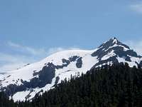
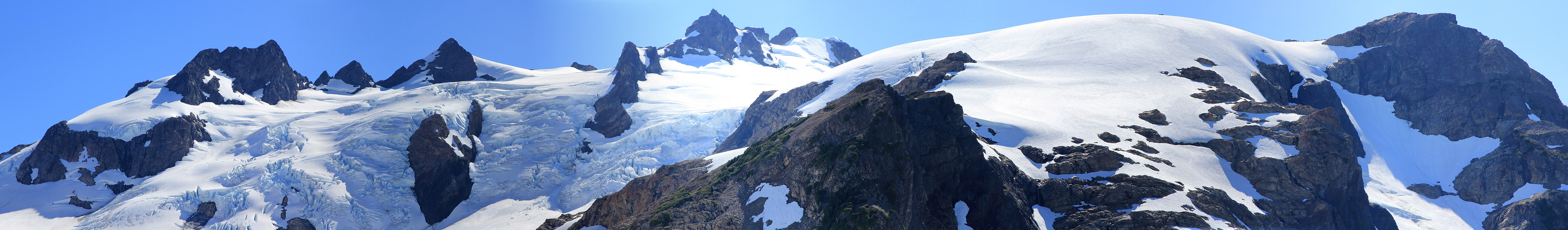
![The Snow Dome and Panic Peak]() The Snow Dome and Panic Peak
The Snow Dome and Panic PeakWe crossed the Hoh River Bridge in the gorge and did not stop until we watered up at Martin Creek just below Elk Lake. We had lunch in the gentle valley just below topping out on the ridge overlooking Glacier Creek. We were passed by John and Linda, a Canadian couple, who planned to reach the top of the Snow Dome and camp that night near Panic Peak. They also intended their summit bid on Thursday.
The rope and ladder crossing the avalanche damage just before Glacier Meadows was docile. One gets the first view of the Snow Dome and Panic Peak from there. We entered Glacier Meadows about 3 PM. We rested a bit,dropped our packs at our camp site, and then scrambled up to the moraine to plan our summit ascent.
Glissading down was worth the climb. We had been kidding Evan about his exaggerated claim of a 4.3 second forty yard dash. He did not want to get his butt wet, so he stayed on his feet, but he was able to keep up by vaulting on the snow while we were glissading. The race left us all laughing. “There goes Evan!” we would say as he passed. When we got back, Eric, the ranger stationed at Glacier Meadows, and Dad reviewed our planned ascent route at the ranger yurt. The Mountain House dinner was chili mac spiced by some chili pepper and olive oil.
Mount Olympus - West Peak
Thursday July 12th. ![Early morning alpine start]() Early alpine start
Early alpine startUp at 2:30 AM and out by 3:40.
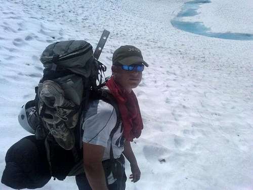
![Traversing the Blue Glacier]() John at the top of the Blue Glacier
John at the top of the Blue GlacierA small delay when Evan went back for his camera. Dad’s phone was dead so we needed Evan’s camera for the pictures.
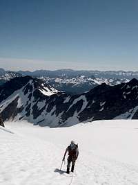
![Climbing the crown of the Snow Dome]() Ascending the "crown" of the Snow Dome
Ascending the "crown" of the Snow DomeThe moon rose at 2:30 AM so we had plenty of light for the 150 foot descent down the moraine to the Blue Glacier.
![The Baker boys on top of the Snow Dome]() The boys on the Snow Dome and the summit ridge of Olympus. Crystal Pass is to the left
The boys on the Snow Dome and the summit ridge of Olympus. Crystal Pass is to the left
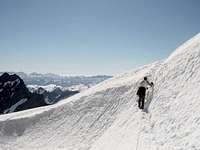
We glissaded down a small snow field, roped up, and picked a route between two small parallel crevasses generally heading toward the east peak. The wind, picked up as it blew down the glacier, about 20 miles per hour. This made the night air chilly, about 15 to 20 wind chill degrees less than the top of the moraine, leaving us with a bit of a mental and physical shock in our early morning hike.
Both rangers, Eric and Matt, had told us to ascend the shelf, staying out of the corner of the glacier, more to the east, to make the ascent of the Snow Dome a bit more gradual. It was light before 5 AM and we stopped for a break at 8:30 AM, on the shelf, in the shadow of a large ice block, which had rolled off the ice fall some weeks(?) ago. Another group of two fellows were following our tracks but they headed more west after our break and ascended the Snow Dome more directly and aggressively. We made the long traverse up to an exposed ridge of rock that brought us to a saddle looking north. We then ascended the last 300 feet of the Snow Dome "crown" directly using the steps kicked in by the team ahead of us.
We thought that once we reached the top of the snow dome that the climbing would all be fairly easy from there. The traverse of the Snow Dome is much longer than it appears. The snow was softening, and with all the other tracks, the walking was exhausting.
We stopped to eat some of our lunch to get our energy level up.
![Crystal Pass]() Crystal Pass
Crystal PassWe reached a small rise and caught a glimpse of the other two man team. We also saw that the Canadians had broken camp and were ahead of us. Both parties were widening the gap from us. They were starting the traverse to Crystal Pass, probably 45 minutes ahead.
Crystal Pass required a traverse across a snow ledge kicked out by earlier teams and a 20 foot climb to attain the snow field below the false summit. It was here we were surprised by the steepnees of the climb up the snow field to the false summit. Most earlier teams had come fairly close to a large crevasse after entering the snow field. Even though there were more than 20 tracks ahead of us we gave another 30 yards clearance to the south while testing the snow as we went.
![Mount Olympus summit block - north face]() The north face of the summit block
The north face of the summit blockThere is a bergschrund between one of the Five Fingers and the ascent to the snow field on the east side of the false summit. The distance on the snow bridge between the two openings was less than 30 feet, but we felt secure since all the previous teams had been that way. My guess is that route over the false summit must close early in the season. We had read of other teams that chose to avoid the false summit and skirt it to the south - perhaps because of this feature.
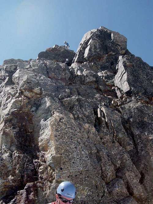
We attained the false summit to find both teams ahead of us just reaching the snow field leading to the north side of the summit block. In order to give them time to summmit, we took a long pack break and watched from afar while John from Canada led the chimney from the snow field. Both teams climbed on separate ropes, the Canadians first.
![Mount Olympus - Summit Block]() The east face of the summit block as seen from the false summit
The east face of the summit block as seen from the false summitWe started the descent from the false summit when the second team executed their climb on the summit pinnacle. John and Linda rapped down before we began our climb. We climbed the short snow field abutting the summit block and started our rock climb while the two man team was on top, above the belay station.
Trip reports, we researched earlier, had all sorts of confusing descriptions of the rock climb with ratings of a 5.4 up to a 5.6. We found the obvious route presented to us to be much easier. John led the pitch without any problem. Pro was everywhere and he put in a couple of friends and 2 slings around several rock handles. The wide chimney (more like a left facing corner) is quite blocky. The conditions that day made it about a 5.2. It may be when the moat at the summit block widens or the snow melt leaves more of the rock face exposed that the moves a bit lower are more difficult. The belay station already had two newly installed slings around a large boulder with one rap ring and a wire gate biner that someone kindly left behind.
We swung leads and Dad handled the 4th class scramble to the summit. He protected with a munter hitch just to be safe. The views were amazing. The Strait of Juan de Fuca to the north and we could see Rainier to the east.
![The false summit]() The view from the summit looking east. See the Canadians on the false summit for scale
The view from the summit looking east. See the Canadians on the false summit for scaleClouds were rolling in from the west, blocking our view of the Pacific Ocean. We stayed about ten minutes with our eyes on the clouds. After obtaining their permission Dad rapped down on the other team’s rope. We could tell they wanted to bug out, so the other team retrieved it, while Evan set up the rappel with our rope. 50 meters was plenty. The Canadians had used a 30 meter rope, which would be a bit short if the climb was longer which should happen later in the season.
Dad was a bit worried about the steepness of the glissade down the summit snow field but the run-out was very safe. All four earlier mountaineers had left this way. “What a woman, that Linda”, we heard the other team say just before they jumped off. The first 50 feet was really quick, almost like a controlled free fall.
We left in a bit of a hurry since the clouds were coming in. By the time we reached Crystal Pass the clouds obscured the summit. We encountered some fog on the top of the snow dome, which made the descents a bit harder to plan, We were glad for the footprints in the snow. We did not bring wands, but this would be crucial for the teams that go early in the season.
We glissaded a good bit of the way down using the more direct route just north of the glacier corner. These fields appear to melt out later in the season from other photos we have seen.
Several of the tracks went down the valley on the west edge of the Blue Glacier, near the rocks, but we chose to traverse well out onto the main part of glacier to avoid any hidden crevasses in the corner. We were told that that area was the site of the last serious injury when a large hidden snow bridge collapsed about 5 years ago taking a full roped team into the concealed crevasse.
We climbed the moraine about 4:45 PM and made camp shortly after. Fourteen hours camp to camp with about 1 ½ hours waiting at the base of the summit block. Dinner was turkey tetrazzini from Mountain House spiced with fresh garlic roasted in a bit of olive oil. Eric invited us by his yurt on his porch to discuss our day. His stories of back country glacier skiing were quite interesting.
The retreat
Friday July 13th. Slept in and left Glacier Meadows about noon. A forced march found us 18.3 miles later at the Hoh Visitor Center. We caught up with the Canadians, who drove Dad around to identify an open campsite. In the meantime, Evan and John tried to convince other visitors to give us a ride into Forks for McDonalds and a hotel that night. No one had sufficient room in their cars for three stinky hikers and gear, so we made camp. However, running water, a flush toilet, a picnic table, and trash dumpsters felt like real luxuries, albeit no shower or real bed. Dinner was the last chili mac.
By the way, it turns out our Canadian friends are something of an item in western Canada. John Baldwin is known for his long traverses on skiis in the Canadian Coast Mountains and his amazing photographs. He has a website,
www.johnbaldwin.ca/, and a 3rd edition guidebook, Exploring the Coast Mountains on Skis.
Saturday July 14th. Pickup at 9 AM by Jon and Teri who brought fresh fruit and chocolate chip cookies. The Rainier cherries were especially good. We got a shower and a pizza in Gig Harbor at their place. We mailed back the snow gear we had borrowed from
Kurt Winkler, Dad’s guide in New Hampshire. (BTW if you are looking for a patient, very skilled guide he is your man) The red-eye from SEATAC found us in NC by early Sunday reflecting on the awesome blessings of comraderie, nature, stellar weather,and safe conditions


 Br
Br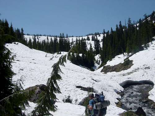


Comments
Post a Comment