Page Type Page Type: Trip Report
Location Lat/Lon: 47.95010°N / 123.733°W
Date Date Climbed/Hiked: Aug 15, 2011
Activities Activities: Hiking, Scrambling
Seasons Season: Summer

The Secret Garden Trail


Secret Garden TR 4
Mount Olympus is the flagship of the range, captivating from every angle.
I am sure you do not need me to tell you that Olympic National Park is popular, or that the High Divide Trail is glorious and very crowded, with good reason.  Well, what you do need me to tell you is that there is a special, untamed alternative in the Sol Duc area which you can add to your trip to get some privacy, do some route-finding, and get even better views than you can on the High Divide's two mile strip.  Plus you'll wade through diagonal oceans of wildflowers, in every color of the spectrum.

An Alternative


You can do all this by taking the Secret Garden trail, which I named myself.  I think there is no official name for this little trail, but this name of mine is ideal.  Check out the pictures and you will see why.  This trail is semi-marked on your topo map of the Sol Duc area: there will likely be dotted lines extended North from the Cat Walk towards Haig's Lake, and possibly to the East and South from Oyster Lake near Appleton Pass.  On the flier the National Park hands out, that is the case anyhow.  This trail is actually mostly worn into the hills all the way to Appleton Pass campground however.  A ranger will tell you the same thing, if you seem capable of the adventure, and you don't piss that ranger off.  I learned about this by being polite, and by asking to camp at Appleton Pass when Heart's Lake was unavailable.  The trail is mostly intuitive, though somewhat challenging to traverse in places.  You can end or begin at Appleton Pass and just remember you are going from the campground at that pass to Haig's Lake.  That single sentence will ease some headaches for you.  I think for that reason alone, you should travel south from Appleton Pass. 

Getting to Appleton Pass

Secret Garden TR 2
Golden sunlight in the Sol Duc forest.
Secret Garden TR 3
Huge old-growth trees tower above.


You will reach the pass by taking the Sol Duc River Trail for 4.1 miles of the prettiest, softest forest land you will ever see, and then going left/North at the fork towards the Pass.  2.6 miles of switchbacks will get you to the pass and the campground.  Look around and find the right campsite for you.  I spooked this bear at the East-most site at sunrise.  I expect bears are more likely to the East.

Once at the Pass


Appleton Pass is beautiful, with a wonderful, sprawling campground.  The only nearby water is at Oyster Lake, hardly a puddle, and for that reason, I chose to camp close in a copse of trees, but you can get as far as 1/2 mile from the campground with some gorgeous views right out your tent window.  Mount Appleton is nearby, but a beast to climb, in that you'll have to bushwhack.  I can't recommend that, nor could the ranger, unless you are trying to grab every summit in the Olympic Range.  But you will have a wonderful sunset anyhow.  (And as a note for those of you thinking: well I'm no baby, I don't mind a bushwhack- I tried it.  You are going up a ridge with flowers, thorns, branches, bushes, loose rocks, bees, and everything else awful you can think of.  In one hour I got about 1/4 mile.  And the views were not getting any better.)

Secret Garden TR 9
Sunrise over Mount Appleton.
Secret Garden TR 10
Sunset from a short scramble above Appleton Pass, just high enough to clear tree cover.  Secret Garden Peak (my name for it) is center.  The Secret Garden Trail goes over a little saddle or pass just to the left of that peak.


Sunrise from Appleton Pass in late summer is even better, with slow golden light tiptoeing through vast fields of wildflowers.  Deer abound near Oyster Lake, which seems to be a favorite spot for them.  I had 6 different deer wander past my camp, which as I mentioned was hidden in a copse of trees.

Secret Garden TR 5
This fawn barely eluded me. I had her scratching herself with so much cuteness your heart might have exploded to see it, but was a second too late with my picture
Secret Garden 11
I spooked this bear by tapping my ice axe thrice on a stone at foot. If a bear doesn't run, it is familiar with people and no longer wild- such bears are dangerous.
.

Secret Garden TR 6
Taken from my sleeping bag just before I closed my eyes.


I had no tent, and only my trusty bivvy sack, so the deer were not even aware of me.  From the campground and the lake, head East on the faint footpath.  This is bear territory so don't stray too far into the thickets of pines. 

Snowpatches will mask the trail depending on the season and traffic.  Now that I am detailing this on a popular website, the trail may see more visitors, which might ease some of the disappearance problems.  As the trail heads South you will notice wooded peaks ahead of you, four.  These are not the popular Carrie Traverse group accessed by the Cat's Walk.  These are not named on your map, and hard to even pick out as summits on smaller topos, such as that offered by National Geographic, which is what I was using.  One of these 4 will be the sheerest and highest.  Your trail will stay just left or East of that summit and cross the ridge at a saddle just to its left/East.  Remember that and you shouldn't get lost.  I'm posting plenty of pictures also. 

I am not going to go into great detail about your step by step travel.  You need to be able to route-find and have some topographic map-reading experience.  If you need or want exact directions, than this is not the trail for you.  After you traverse the several small wooded peaks you spotted from Appleton Pass, you may lose the trail for a while.  Just watch for a lake.  It will be Haig's Lake and aim straight for it.  I did not know this when I was taking the trail, but I trusted that any lake on earth with a fish in it even once upon a time will have a foot path to it.  Fishermen above all others covet solitude and secret spots. 

This trail should take a few hours.  Maybe a half day tops.  Its pleasant and pretty.  You can grab a peak or two while you are at it.  I named the highest peak on the ridge "Secret Garden Peak" and the peak it shares a saddle with, which sits just East, "Wildflower Mountain".  I went to the top of Wildflower Mountain to look back at the whole trail.  See the picture just below.  The view back to Mount Appleton and Pass was marvelous.

Secret Garden TR 1
Looking back at my morning's travel from the summit of Wildflower Mountain.  The peak is Mount Appleton (far distance) and the Pass and campground stretch from there to the forested smaller peak to the right.


More details about The Secret Garden Trail


Secret Garden TR 15
Sunrise along The Secret Garden. Secret Garden Peak (my name) is on the left. The trail curls around to a saddle on its left.
This trail is pretty low on mileage.  I estimate it at a little under 2 miles, but there may be lingering snowpatches to cross and for this reason, I carried an ice axe.  I only used it for 30 seconds, but I was glad to have it for those 30 seconds.  I did more falling during the third 1/2 mile stretch than I have ever done in an hour in my life.  Navigation becomes tricky through trees and steep slopes.  If the trail owes its existence to anyone, its likely more to goats than people (or bears- did I mention I saw three?).  But the trail is so faint it is easy to wind up on dead ends and false spurs.  Plan on that ahead of time.  I was camping at Heart's Lake and so did not need to rush, thankfully.  My legs and feet were pretty tired by the end of the trip.  Haig's Lake is ugly so I did not cool off there.  It was also buggy.

Secret Garden TR 16
Traversing Wildflower Mountain towards the pass/saddle shared with Secret Garden Peak.

Secret Garden TR 17
Traversing another mountain after the pass. Haigs Lake will be down and to the right (East) in about 1/2 mile after going over this hillside nearer the pines.

Ideal season is probably about when I was there: middle August.  You should have plenty of flowers at any time in August, and most of the snow will be gone.  Snow on this trail would mostly be annoying in my opinion as much of the route is "side-hilling".  August is also Washington's driest month.  I spent 17 days in Washington, with this trip being one of my last legs of the journey, and I got in 14 summits, and about 170 total miles, and was never rained out a single day.  I did lose one morning to rain.  That is much better fate than I had in Montana the same season. 

Secret Garden TR 20
Zoom of Mount Olympus near sunset from the Catwalk Climber's Campsite.


Secret Garden TR 18
Sunset to the East from what I vote for as the best locale in the area.  Request the "Catwalk Climber's Campsite".

Secret Garden TR 19
From my favorite sunset spot, a wide shot of Mount Olympus and its nearby friends.  Yes you can click on it and then click on it again to zoom in.  It only impresses at full-screen.

About the Surrounding Area


Secret Garden TR 14
Heart's Lake plus a snowbank in a heart shape.
Heart's Lake is heart-shaped, and cute in its way.  The campground was under nightly assault by goats last summer, and that is likely any year.  Secure your food well, and your whole campsite.  Goats were screaming and digging all around me all evening, though I chose the site farthest from the lake in the hopes of dealing with them less.  If you've never heard goats in the night, well, once you do, you will know why they are associated with the devil. 

There will be bears in this area.  I saw two more before sunset when I went back towards the Secret Garden Trail for the best sunset in Olympic Park.  At least, in my opinion.  This spot (photos are above) is on the Cat Walk, near a single campsite which could actually hold several tents easily.  You will take a spur to the left/North.  I recommend it.  The campsite would need to be reserved and there is water nearby, though just one little buggy snowmelt pond.  Filter heavily.

High Divide Trail was a let-down after Secret Garden, and also because the sky was hazy for my exit morning.  Still, Sol Duc in August is wildflower paradise.  I saw plenty more and had a great morning.  People in Washington do not seem to move very early in the morning, so rise with the sun, and even on crowded trails you may find yourself all alone.

Secret Garden TR 12
Sunrise from the High Divide.
Secret Garden TR 13
Near the West end of the High Divide Trail, heading North along the Deer Lake fork to complete my loop.


Bogachiel Peak was unimpressive to say the least.  But if you want to pad your summit stats, then its a short diversion of only a few minutes.  The Sol Duc falls are beautiful.   The scenery of people with enormous packs is great comedy.  Some of the packs were larger than some of the people carrying them.  Yet as usual in Washington, I was mocked for having an ice axe.  Really?  My pack weighed under 20 lbs, so let's not talk who has too much gear.


Secret Garden TR 7
The Sol Duc Falls are popular for a good reason.
Secret Garden TR 8
Crowds will form as soon as you leave The Secret Garden Trail.

The total distance for the typical Heart Lake/High Divide Loop and the Secret Garden Trail extension is around 19 or 20 miles.  It could be done in a day, but with scenery this lovely, I don't suggest you try.  Also it can be hard to "speed" in heavy traffic and others will be moving slower than you would need to.  Stretch it out. 


Comments

Post a Comment
Viewing: 1-4 of 4
DrJonnie

DrJonnie - Mar 20, 2013 6:48 am - Voted 10/10

Entrancing area

great report and a fantastic unspoilt (?) wilderness.
Loved the final photo too! the locals with their sherpa sized packs
cheers Johnnie

andrew david

andrew david - Mar 20, 2013 7:31 pm - Hasn't voted

Re: Entrancing area

Glad that people are liking my report. I saw even bigger packs in the Hoh Rainforest for the guys going up Mount Olympus itself. I prefer to save my legs and be a little cold at night, but to each their own. Some of the people I passed on a day hike were dying after a few miles though, and they had like 15 more to go before even gaining elevation. But they really were mocking me for having a mountain axe.

DrJonnie

DrJonnie - Mar 25, 2013 5:29 am - Voted 10/10

Re: Entrancing area

Well Andrew,
I'm afraid we Brits are prone to carrying everything including the kitchen sink so we have to make a big effort to lighten up.
There is a goodly section of outdoor types over here now thinking seriously about lightweight travel, every once counts on steep hills. I've been guilty myself of sawing my toothbrush in half to save a bit of weight. BUT ! we could have saved ourselves 50 metres of step cutting last year on Pico de la Mina if we had taken our crampons on the ascent!
cheers Johnnie

olympicmarmot

olympicmarmot - Jan 31, 2014 2:13 am - Hasn't voted
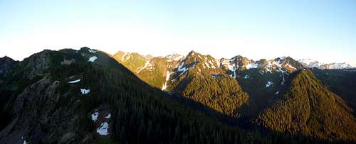
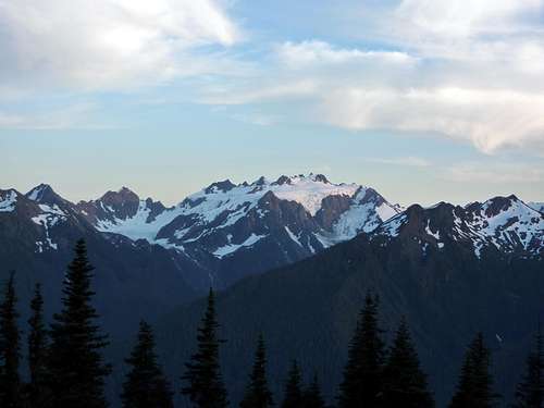
that would be...

The cat creek way trail...and spread eagle pass

Viewing: 1-4 of 4


Parents 

Parents

Parents refers to a larger category under which an object falls. For example, theAconcagua mountain page has the 'Aconcagua Group' and the 'Seven Summits' asparents and is a parent itself to many routes, photos, and Trip Reports.

Olympic Range (WA)Trip Reports