The Journey to Oregon
This is a long one. At the commencement of this scheduled three-week adventure, the distant Pacific Northwest was the most glaring omission from my previous travels. After one year of planning, I literally could not wait to go, as I feigned sickness a day early to get a head start. Every extra bit of time would enable me to enjoy the sites along the Oregon Trail, my route to this trip's principal destinations in Washington.
![Mitchell Pass]() Mitchell Pass on the historic Oregon Trail.
Mitchell Pass on the historic Oregon Trail.![Saddle Rock Trail]() Saddle Rock Trail view.
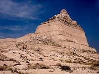
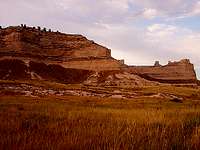
Saddle Rock Trail view.![Scotts Bluff]() Scotts Bluff, Nebraska.
Scotts Bluff, Nebraska.
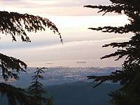
I crossed the Missouri River during the night, and I stopped for a brief nap before continuing west from a Nebraska interstate rest area. The braided nature of the Platte River was new to me, but this Nebraska part of the trail was mundane until the river forked. I followed the North Platte until a neat landmark, Chimney Rock, appeared in front of the afternoon sun. I could first make out the rock formation about ten miles away, and state route 92 traced the path of the trail right past it, just as pioneers had done in the 19th century. A few miles farther, I parked at the Mitchell Pass view of Scotts Bluff, another famous feature along the trail’s historic route.
The paved Saddle Rock Trail provides a panoramic view of the bluff before it brings you a closer experience. Several sedimentary layers, including one standout white stripe, are capped by exquisite shapes of soft eroded sandstone. Inside the trail tunnel, near which I grabbed my own souvenir rock, there are many examples of inquisitive people rubbing into the pale stone. At the top, high above the North Platte River valley, the geological survey marker stands oddly well above the surface, unwittingly serving as an amazing reference to eighty years of erosion. Make no mistake, this natural monument’s time is running out on a geologic scale. After looking to the horizons with my binoculars, I started back. In one narrow section, I politely yielded to an oncoming girls’ cross country team. The main pack had callously left one slow girl in their wake, so I followed their example and did not yield for her. Actually that is untrue, I felt bad for her so I smiled and encouraged. With no camping prospects here, I had to cross into Wyoming to the nearest interstate rest area. Tomorrow, I looked forward to actually sleeping outside of my car.
Day Two 082711
Another day of extended driving loomed for me, so I tried my best to start it quickly, going west across the heart of the Equality State. From the Powder River Basin to the Shoshone Basin, the isolated feel of the area is striking. Mountains lie on the horizon in nearly all directions, but this central strip of the state is mostly flat scrubland. It remained so until I ascended the Wind River Valley past the continental divide, putting the Teton Range in my sights. Route 287 was under major construction for the last several miles to Moran Junction. The roads were very rough and full of construction equipment, but the escort vehicle’s repeated stops just gave me more time to gaze at the Tetons.
I eventually entered Grand Teton National Park at Moran Junction and turned north. Pretty quickly, the park road pulled alongside Jackson Lake. Here on the east shore, the sights of the Teton Range and its fuzzy reflections blanketing the lake were gorgeous. I stopped at a turnout so I could take a few pictures, thinking all was well. After a short walk down the lakeshore, however, I noticed a problem back at my car. The left rear tire was almost sitting on the rim. I limped about ten miles ahead to a nearby Bridger-Teton National Forest campground I previously researched, where I hatched an improvised plan to park, mount the spare tire, and camp. But then I reached the “bridge” over Sheffield Creek. It was a ragged series of uneven concrete blocks set at ground level, with the creek flowing over it, suitable only for serious high-clearance vehicles. I methodically reversed about an eighth-mile or so, with the rear tire now completely flat. At a shaded parking area overlooking the upper Snake River, I found a souvenir rock down near the bank, and then I set to work on the spare tire.
I had to unload my disassembled bicycle and other stuff from my trunk before I could access my spare, so picture that momentarily resting on the ground when a faded red pick-up truck darted in from nowhere. It sported North Carolina plates and considerable tan-colored mud on its wheels and tires. The first thing the passenger leans out to say is “Hey man, I don’t think that’s gonna fit there!” I turned and looked at my bicycle tire, which I had leaned directly against my car’s flat tire. The occupants both cackled with delight, and I did too, because it was such a magnificent way to make an entrance. I walked over and chatted with them for a few minutes. Of course, being southern gentlemen, they kindly volunteered to help me out with my tire, but I had it under control. When they turned around and left, their good-natured humor had already made my day. I can always use a good dose of the south. With a scenic river view below me and a happy vibe now pulsing through me, changing the tire was no inconvenience at all.
|
|
| After noticing a flat tire here at Jackson Lake... I changed it here beside the Snake River. |
![Upper Geyser Basin]() Yellowstone's bubbling springs.
Yellowstone's bubbling springs.![White Dome Geyser]() Yellowstone's erupting geysers.
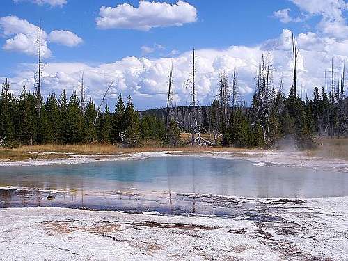
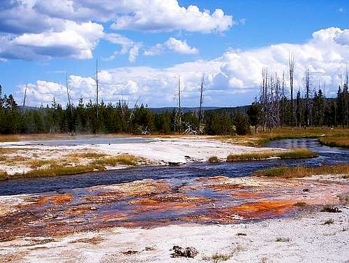
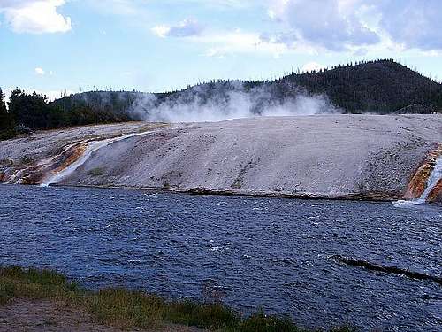
Yellowstone's erupting geysers.My flat tire was sitting in the passenger seat, my donut spare tire was securely mounted in its place, and I was on my way into Yellowstone National Park. There were masses of other tourists here, which is exactly why the park was originally an afterthought for me. I bypassed the West Thumb and Old Faithful areas, but when I approached several pockets of steam rising from the ground, I could not pass up the Midway Geyser Basin. The one-of-a-kind thermal activity here was such a novel sight to see up close. The vivid colors are the first thing I noticed. Hot springs of light blue water contrast with the surrounding burnt orange microbial crust and the ever-present dark green pine forest. Some of the larger pools, such as Grand Prismatic Spring, are shrouded by thin layers of steam. As I shuffled nearer on the crowded boardwalk paths, I felt the heat radiate all around me. The variations within the thermal areas really indulge all the senses. Later on, I encountered peculiar mud pots exuding a sour odor of hydrogen sulfide. At dry fumaroles, where only steam and gases emanate, the sound of rushing air is loud and constant. These amazing features were a diverse experience packed within a relatively small basin.
|
|
| Green Spring and Iron Springs Creek in Yellowstone's Upper Geyser Basin. |
Going north from there, I traversed the Firehole Lake Drive just in time to see an eruption from the large White Dome Geyser, and I eventually reserved a pricey site farther north at the Madison Campground. On a late evening walk, I went down to the swift Madison River for a small souvenir rock and I ambled around in the water. Despite the hot geyser runoff up the nearby Firehole River, it was quite cold. Between the current and the slippery rocks on the riverbed, I slipped and stumbled enough to get my clothes wet. But I enjoyed this as well as my visit to the geyser basin. Despite the crowds, the distinctiveness of the features here makes this a place impossible to bypass. I still maintained that sentiment as I lied in my sleeping bag, unable to sleep, listening to my campsite neighbors’ children fight and bicker within their tent.
![Grand Prismatic Spring]() Grand Prismatic Spring. Grand Prismatic Spring. |
![Firehole River]() Excelsior steaming behind Firehole River. Excelsior steaming behind Firehole River. |
Day Three 082811
I may have been the first camper up and moving at Madison. Once packed, I set out southwest from Yellowstone through the northern reaches of Idaho’s Snake River Plain. My route hugged the southern extent of the ranges bordering the plain, from the Bitterroots to the Pioneers. Almost two hundred miles from Yellowstone, the plain landscape suddenly shifted to a desolate expanse of jumbled, flat black lava fields. I was at my next stop, Craters of the Moon National Monument.
Overnight, I had given some brief consideration toward getting all the way into Oregon today, but seeing this park convinced me to stop and spend a day here. I reserved a site at the Lava Flow Campground, perused my park map, and decided this was a park best enjoyed via the bicycle. This was a used bicycle that I had ridden for only one minute just before this trip. In the process of assembling the bicycle for its first real use today, I was unable to configure the brakes properly. I had tools, so I could have resolved the issues with patience and a concerted effort, but I got bored and just took off along the seven-mile loop road. My first stop was a look down inside the Spatter Cones display. Just beside that was Inferno Cone, a high point mostly representative of the whole area. A few sagebrush bushes were clustered in places, and some lichens dotted the landscape, but the rest was bare cinders. The cinders were black or sometimes slightly reddish-brown, and they emitted a distinctive crunch when stepped upon. The sharp-edged larger rocks of solidified basaltic lava were pocked with tiny air bubbles, making them surprisingly light.
![Craters of the Moon]() Beside Inferno Cone. Beside Inferno Cone. |
![Inferno Cone Summit]() Inferno Cone summit. Inferno Cone summit. |
![Spatter Cones]() Empty spatter cones. Empty spatter cones. |
![Lava Cascades]() Desolate lava cascades. Desolate lava cascades. |
Just east of Inferno Cone, the lazy park loop road suddenly drops off a table. When I discovered the crest on my bicycle, I abruptly stopped to reassess the situation before I ultimately continued. The next fifteen seconds of my life were equally terrifying and electrifying. I will never know for sure how fast I was going, but it felt like every bit of forty miles per hour, on a bicycle I had haphazardly assembled moments earlier. One of the things I flew past was a closed road to the Wilderness Trail area, so once I coasted to a safe stop, I turned around to explore. The road barricade was defenseless against my bicycle and me. The ride alongside shimmering black lava cascades was better than the destination; the recreational areas were in the process of construction. I turned around and revisited my campsite for a break.
After making a more concerned check of my bicycle, particularly the brakes, I acquired a spelunking permit at the entrance gate and started a second lap of the park. Of course, I circled around for another exciting downhill run from Inferno Cone, and then I stopped at the cave area hidden within the lava fields. I hiked out to Beauty Cave and explored it with a flashlight, taking a souvenir lava rock from the cave end. I also explored Boy Scout Cave, which offered a pretty tight section where I had to scoot along on my belly. Indian Tunnel was the opposite, offering enough room for a bus or two. From the caves, I returned to the campground for a very enjoyable hike along the North Crater Trail. It offered a lot of local elevation change and views of smooth, ropy pahoehoe lava flows. I stayed out on the trail long enough to use my flashlight, completing a full day of discovery around this peculiar landscape. Once I was back, I fulfilled a park ranger’s invitation to the campground’s evening program. In it, I sheepishly got to paint my very own picture of the scenery. My picture was terrible, but the actual scenery was great.
![Inferno Cone Summit]() Pioneer Mountains from Craters of the Moon. Pioneer Mountains from Craters of the Moon. |
![Devils Orchard]() Devils Orchard in Craters of the Moon. Devils Orchard in Craters of the Moon. |
Steens Mountain, Oregon
Day Four 082911
The night was a little windy, but I had lined the tent with enough of the basaltic rocks to keep it stationary. Going west from Craters of the Moon, I followed the Goodale’s Cutoff Route of the Oregon Trail across the steamy Snake River Plain. My automobile tire situation remained just as it was two days earlier in Wyoming, with the donut spare in use and the flat regular tire in the passenger seat. Obviously, I was not thrilled to wedge some auto repair expenses into my trip budget, but it was my only choice. Once I got to Boise, I stopped at the first tire shop in sight, which referred me to the second tire shop in sight. I got to watch Groundhog Day in the waiting lobby while two new rear tires were mounted. Not just part of the movie, but the entire film through the credits. For whatever reason, the process took forever.
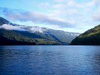
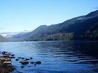
Once I was back in the heat, I traveled a busy interstate highway to the Oregon border, where I seemed to leave civilization behind. Eastern Oregon is one of the least developed areas of the United States. For almost two hundred miles through northern Great Basin territory, I did not see much of anything besides sagebrush, junipers, and clear skies. I was headed for Steens Mountain, a fault-block mountain so remote that I was irresistibly drawn to it. The sun was close to setting when I finally reached the northern half of the Steens Mountain Loop Road. Jackman Park Campground was fifteen miles of rutted gravel road ahead. In an effort to preserve my low two-door coupe, I very patiently took an hour to reach the campground. The road really was that bumpy. That allowed the sun to fully set, leaving a beautiful pink horizon at the base of the mountain’s long western slope. I admired the sight, set up my campsite, and brought an end to this travel day.
![Steens East Rim]() Steens East Rim.
Steens East Rim.![Wildhorse Lake]() Wildhorse Lake.
Wildhorse Lake.
Because yesterday was fully devoted to travel and automobile repair, I set out to make the most of today on Steens Mountain. As a tilted fault-block mountain, this is not a typical high point in the sky. The east face of the mountain very steeply rises over a mile above the Oregon high desert, but the west slope gently extends for twenty miles. The face itself stretches north-south for thirty miles, but technically it is still one mountain, not a range. Anyway, even after my tedious drive up the west slope yesterday, I was still seven miles from the summit via the loop road. Driving seemed like an undesirable option, but another bicycle excursion was a welcome choice. Once the sun vanquished the chilly morning, I assembled my bicycle and continued my trek up the mountain.
On its winding course, the north side of the loop road ascends through miles of junipers eventually to a sub-alpine carpet of low-lying grasses. This transition occurs very gradually on the steady west-to-east incline. Most of my remaining four miles to the rim and three miles along it was in the sub-alpine zone. Although I was in fine physical condition, that does not mean I was able to breeze up this seven-mile grade. During my rests, I started to walk the bicycle, and gradually my riding yielded more and more time to walking. In full disclosure, I entirely walked at least the final thirty minutes to the east rim. But do not tell that to one particular family of minivan tourists I encountered along the rim. They presumably drove past me on the way up, and as we met again, they cheerfully congratulated me on “riding” all the way to the top. For this moment, I abandoned my usual candor to, instead, firmly puff out my chest and thank them.
The east rim sure was an indulgence for the eyes. As I anticipated, that first view out from the rim’s edge was superb, well worth my effort biking and walking there. But the neatest features were the massive gorges created by ages of glacial erosion. Kiger Gorge is gigantic and dramatic with a masterfully sculpted concave shape. Going south alongside the rim with a new souvenir rock in hand, I marveled at the Little Blitzen and Big Indian Gorges for their depth and colors. The particular mixture of colors here, not just on Steens but in much of southeast Oregon, was so unlike what I have seen in other mountainous regions. The basalt rock is a dirty brown with almost a slight tinge of purple in shade. Up close, there were colorful blooms of paintbrush or thistle that blended into the dry maize grass from a distance. These dry grasses mixed with the exposed basalt in every place but the bottoms, which enjoy the moisture funneled down from the walls.
|
|
| Little Blitzen and Big Indian Gorges on Steens Mountain. |
The true summit of Steens Mountain stands near the southern end of the loop road’s rim segment, and as I explored, I made my way to it in due time. This is not a very exotic summit. The pathway is an abandoned four-wheel drive road that leads to a communications station immediately beside the high point. One benefit of the station is that it makes a nice windbreak from the moderate breezes here at 9700’ altitude. I took advantage of this and watched over the hazy Alvord Desert as I snacked from my backpack, while scratchy voices periodically boomed from inside the station to break the silence. I hiked back down the road and wandered off-trail to the edge of the Wildhorse Lake Overlook. There was a trailhead here that led down to the beautiful lake and its adjacent gorge, and I had designs on hiking it. But then I heard the dull clunking sound of my mosquito repellant hitting the ground. My rear backpack pocket was open, and while the repellant was on the ground beside me, my flashlight was nowhere in sight. I decided to do all the off-trail backtracking that I could remember, and remarkably after twenty minutes of wandering, I actually found the flashlight near my lunch spot.
The diversion was not that long in the grand scheme of the day, but it still changed my mind regarding a hike on the Wildhorse Lake Trail. I returned to my bicycle instead. At first, I would say I was riding down the mountain, but soon I was careening down the mountain in terror. Certain aspects of the bicycle assembly, while not as evident on a slow and smooth ascent, are utterly unmistakable on a fast and bumpy descent. My handlebars were wobbly, and my brakes seemed to relax after any sort of prolonged use. It really was terrifying on this loose gravel at speed. Once I utilized my boots to maintain friction on the tires, the ride became less perilous. I returned to my campsite for refreshments, and I spent the day’s final hours exploring around my campground, reading a book at some of the more tranquil spots beside creeks or in juniper stands.
![Steens Summit View]() Alvord Desert from Steens summit. Alvord Desert from Steens summit. |
![Kiger Gorge]() The vast Kiger Gorge. The vast Kiger Gorge. |
![Malheur Lake]() Malheur Lake northwest of Steens Mountain.
Malheur Lake northwest of Steens Mountain.![North Santiam River]() North Santiam River in the Oregon Cascades.
North Santiam River in the Oregon Cascades.
I spent a lot of time awake during the night for two reasons. First, it was very cold and I needed to add more layers of clothing. Second, the cloudless skies combined with the high altitude and remote location to create a nice celestial display. Although the haze of regional wildfires here diminished some of the clarity, it was still worth viewing. I got out my binoculars for some amateur stargazing while I shivered inside about four shirts and three blankets. In the high desert, the scale between the daytime highs and nighttime lows is quite amazing. It was chilly yesterday morning, but there was outright frost on the ground this morning. In the late afternoon at my camp yesterday, it was eighty degrees according to my thermometer. The morning reading was thirty-one degrees. There was no unusual cold front; such a daily variation is just typical here.
Northwest of Steens Mountain, I stopped at Malheur Lake just to take a closer look at a peculiarly large body of water for such an arid area. Although annual rainfall in the Harney Basin is often less than ten inches, that is still enough to sustain a seasonal lake surface area of around seventy-five square miles. In the town of Burns, I was disallowed from pumping my own gasoline, which is apparently illegal in Oregon. Then on the outskirts of town, I was pulled over by local law enforcement, not regarding the gasoline but for allegedly driving on the shoulder. The officer must have been a fellow outdoors enthusiast, because he digressed and we instead chatted about my trip. I was happy to show him my bicycle and rocks in the trunk, although now that I think of it, that may have been his clever way of searching my car. In parting, the officer advised me to direct my travel plans away from Washington, because “Oregon is better.” I continued westward to Bend, where the high desert of sagebrush finally disappeared in favor of firs and pines on the eastern foothills. Soon I was immersed in the Deschutes National Forest, near some of the Cascades’ famous peaks. Mount Jefferson in particular was very striking to me, perhaps the most photogenic mountain I have seen to date. It appears very symmetrical from the south with a conical summit common to stratovolcanoes. I had several good looks of it along the West Cascades Scenic Byway.
In hindsight, I wish I had partially heeded the policeman’s advice for at least a day to hike this region. Instead, I parked at Whispering Falls Campground in the Willamette National Forest early in the evening. My primary thoughts already focused on the next day, when I would reach western Washington. I was so energized about my next destination that I told an unprepared campground host all about it. I was following the general route of the Oregon Trail on my trip to Washington. He just looked at me with a blank stare and wished me a safe night camping. His lack of enthusiasm did not deflate me though. I explored the banks of the rushing North Santiam River and erected my tent inside a tall stand of red cedars, where I awaited tomorrow.
Washington's Olympic Peninsula
Day Seven 090111
I departed the national forest on the West Cascades Scenic Byway, which routed me to Oregon’s state capital of Salem and largest city of Portland. Just west of the Columbia Gorge, I crossed the great Columbia River into the Evergreen State of Washington. The most impressive sight during the two hours getting to the Olympic Peninsula was the occasional glimpse of Mount Rainier. I never got that close to the mountain along Interstate 5, but its tremendous size is still visible from afar. When I neared the far southern extent of Puget Sound, at last, I entered the Olympic Peninsula for the first time.
![Strait of Juan de Fuca]() Strait of Juan de Fuca.
Strait of Juan de Fuca.US Route 101 travels in a rough circle around the exterior of the peninsula, with the pristine Olympic Wilderness resting in the middle. I entered from the southeast and followed the route north along the edge of the Hood Canal waterway. I drive slowly pretty much everywhere, but here the narrow roads and sharp bends actually dictate it. There are access roads periodically spaced all along the perimeter of the peninsula. None of the roads span across the park but they branch into it, and these are the options for visiting the Olympic interior. I bypassed the options on the drier east side, instead going first to Port Angeles on the far northern shore. At the park headquarters, I acquired a backcountry permit for an ambitious multi-day hike on the peninsula’s west side. This was sort of a backcountry baptism for me; my first multi-day backpacking trip. Without fully knowing what to expect, I deferred to the park ranger on the specifics of my itinerary. I may have come across as clueless but she approved my permit nonetheless.
That was my activity for the next day, but there was still time today to do something on the north side. I left the visitor center going toward Hurricane Ridge until I reached the Heart O’ The Hills Campground. The vacancies were limited, but I did not have the luxury of being selective this late in the day. As shadows from the adjacent forest already covered my tent, I started on the Lake Angeles trail with a sense of urgency to avoid a nighttime hike. The path was a constant climb up the slope toward the interior Olympic Mountains. At this elevation, between 2000 and 3000 feet, the slopes are covered with a dense montane forest of mostly firs and hemlocks. There was great potential for views to the coast but the trees were always too concentrated. The first posted overlook, according to the trailhead bulletins, did not arrive until the 2.5 mile mark. When an hour had passed, the forest was noticeably beginning to darken but I had still not reached any overlook. My pace was exhausting me, but I still pushed ahead hastily for at least a few more minutes. That overlook had to be just around the corner. Then I continued forward for just another few more minutes, while I worriedly checked my watch every other step.
At last, I spotted a small precipice beside the trail that offered a tiny window to the coast. The depth of visibility with the naked eye was stunning. Through the gap in the forest, I could see not only to Port Angeles, but across the Strait of Juan de Fuca all the way to Canada. On Vancouver Island about twenty-five miles away, the setting sun created flickering reflections that shined from the Victoria metropolitan area. Gigantic freighters in the dividing strait looked tiny and motionless. I gazed until I could wait no longer to return. Even with a flashlight, I did not embrace the idea of hiking the forest alone in the dark. My descent was less of a hike and more of an amateur foray into trail running. The available daylight inside a forest is always more short-lived than outside of it, so I did have to shine the light for a short time. But my final walk through my open campground was just barely possible without it. So instead of choosing between seeing the view and avoiding a nighttime hike, I was essentially able to have it both ways.
![Lake Crescent]() Lake Crescent east shore.
Lake Crescent east shore.![Lake Crescent]() Lake Crescent south shore.
Lake Crescent south shore.
I alluded earlier to the crowded nature of this campground. One constant with these crowded national park camps is that some neighbor will keep me awake longer than I wish, and that was no different here. But now I could further look forward to the expected solitude of the imminent backcountry trip. I resumed my journey counterclockwise around the Olympic Peninsula, and my next stop was the southern shore of Lake Crescent. It was a lengthy lake of several miles, with each bank bordered by steep forested ridges and low-lying clouds. Farther west in the Sol Duc Valley, I started to pass through several pockets of misty fog on an otherwise clear morning. The fog sometimes lifted to unveil a dense forest on all sides that seemed brighter and more diverse. This was the lush temperate rain forest that dominates the west side of the peninsula, the first driving force behind this vacation. Ever since I first read about it and viewed pictures of it, this rain forest captured my imagination. I could not wait to visit. Now I was about to.
I turned on the Upper Hoh Road, a very narrow and twisting road that pierces the Olympic interior for eighteen miles to the visitor center. It follows the Hoh River Valley upstream through a tunnel of overhanging trees that crosses seemingly infinite small streams and tributaries. I now had a small taste of what I was going to encounter from the visitor center trailhead. In the overnight parking lot, it took me a while to load my backpack with as much food and water as I could. I ended up just wearing all my layers of clothing to create extra space inside the pack. Just after noon, I picked up my walking sticks and embarked on the Hoh River Trail.
![Hoh Rain Forest]() Hoh Rain Forest mosses.
Hoh Rain Forest mosses.![Hoh River - Lewis Meadow]() Hoh River near the trail.
Hoh River near the trail.![Waterfall & Ferns]() Hoh Rain Forest ferns.
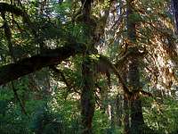
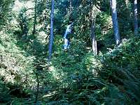
Hoh Rain Forest ferns.Up close and in person, the temperate rain forest presented itself as an especially unique environment. The vegetation was very densely clustered on the ground, particularly by abundant ferns. There were more beautiful ferns here than I have seen in my lifetime. The only thing resembling bare ground was the maintained trail. High above the underbrush, innumerable tall hemlocks and spruces reached for the sky. They are tree species I have seen before, but these specimens are so distinctive because of the mosses. Limitless mosses cling to the trunks and drape down from the branches of every tree in sight. Some of them were as bright green as the ferns, and some were a paler green turning to light brown. Downed trees and logs were pretty common all along the ground here. They too were blanketed by the verdant moss. Today was dry with clear skies, which seemed sort of odd inside this forest. The whole environment gave the impression that it was destined to be dripping with moisture, and with 150 inches of rainfall per year, it usually is.
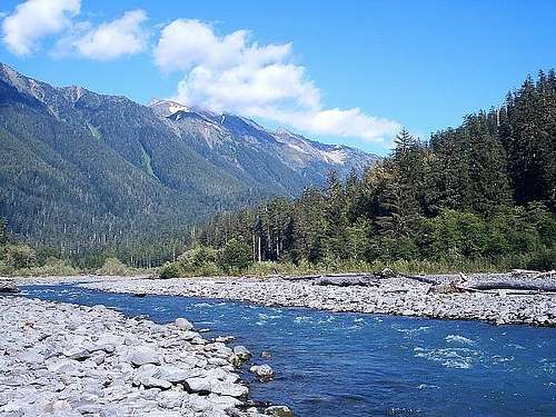
The Hoh River Trail was a very gentle stroll through the rain forest. Going toward the interior mountains, I was gaining some altitude but doing so imperceptibly. The river paralleled the trail closely enough so I could often hear the water tumble downstream. In areas where I walked along the bank, its open views invited me to stop and take a break. I needed those breaks because I was not accustomed to carrying such a loaded backpack. It took me several hours to near my campsite at Lewis Meadow, ten miles from the trailhead. The rain forest changed very little over the course of my hike; there may have been drier mosses and a few more fallen logs, but they were subtle differences. After raising my tent near the river bank at Lewis Meadow, I had a couple of daylight hours to further explore the river and forest.
Clear skies warned of a cool night ahead, so I gathered a little bit of downed wood for a small campfire. Best of all, I stumbled upon a surprising clump of dry grass to ignite it later. The river was simply gorgeous. The banks were wide swathes of pale white rocks, the water was a bright and striking shade of bluish-gray. Because of the grinding effects of glaciers higher in the Hoh watershed, the water here has a high content of glacial rock flour that creates such a singular color. There were several barren tree trunks spaced along the river bank in addition to those pale rocks. The largest of them provided a dry walkway above the river, and I managed to traverse it without falling off. Night soon approached, so I went back to camp to consume my granola dinner beside a pleasant fire. After ten miles, I was a little more than halfway from the trailhead to Mount Olympus.
|
|
The Hoh River in Washington's Olympic Wilderness. |
Day Nine 090311
The chill of the night was so prevalent, or I was so unprepared for it, that it drove me to do something for the first time. In the wee hours, I actually dragged my tent away from its original location to the fire ring and started a new campfire. I spent a fair amount of time huddled around that precious fire underneath sparkling starry skies. The only sound I heard, other than the occasional crackle of a burning branch, was the rushing water of the Hoh River nearby. Once I was slightly warmed, I managed to sleep a few more hours and wake up reasonably energized for my second day in the Olympic Wilderness.
Very soon after departing Lewis Meadow, I began to climb noticeably away from the lushness of the rain forest back into the montane zone. The montane area seemed dense two days earlier, but this transition ushered in a comparatively thinner forest, absent of the green ferns and mosses. The trail rose sharply now with each step. I left the Hoh River behind at a dramatic gorge crossing, perhaps a hundred feet above the rumbling water. Shortly afterwards, things became very interesting. I reached an abrupt halt at an avalanche chute, where some hikers were deliberating whether to continue. The chute of loose rock was tremendously steep; it was only navigable by the presence of a large ladder made of rope and wood planks. For the other hikers afraid of heights, it became a convenient turn-around point, but I forged ahead. The ladder was admittedly a crazy sight, but it was a routine descent at a steady pace. I set down my walking sticks, and then I clawed my way up the rocks on the other side. Mount Olympus was ahead.
![Upper Hoh River Trail]() Nearing the tree line.
Nearing the tree line.![Approaching Blue Glacier]() Seeing Blue Glacier ahead.
Seeing Blue Glacier ahead.By the time I reached the Glacier Meadows backcountry station, the fir-dominated subalpine forest was all around me, both above and beside. There were remarkably as many trees lying on their side as standing upright. From the station, I started the final segment to the glaciers of Mount Olympus. It was another half-hour of steady climbing until the trees just abruptly stopped. The scenery opened up to an alpine meadow of late summer wildflowers fronting the lowest extent of Blue Glacier. For a better look at the glacier, I scrambled up rocks and gingerly walked across the melting snowpack to the glacial moraine. The ice cold meltwater was a refreshing drink along the way. I could barely glimpse the north ridge of the Hoh River valley behind me, my home for the last day. The meadow flowers were in bloom and the ridges were webbed with bright snow patches above the fir-covered slopes, an utterly beautiful vista. Here I dug into my stash of jerky, nuts, and dried fruit before returning down the wildflower meadow. I needed to start back toward my scheduled Hoh River campsite, but then I paused and reflected on my surroundings. It required so much effort to get here, and I wanted to hang on to this area a little longer. So I did just that. I returned back to the snowpack and this time scrambled up to the crest of the glacier’s lateral moraine. Here the majestic sight of Blue Glacier greeted me from below. What an awesome sight. I walked along the loose moraine a little bit to take pictures, but this was ultimately the farthest extent of my backcountry hike. The glacier was riddled with cracks and crevasses, and I was ill-equipped to advance over them. Here on the moraine, I grabbed a souvenir rock and lingered a while before beginning my return.
![Glacier Meadow Ridge]() Mountains across the valley. Mountains across the valley. |
![Glacial Moraine]() Approaching glacial moraine. Approaching glacial moraine. |
![Blue Glacier Tip]() Close look at Blue Glacier. Close look at Blue Glacier. |
|
|
Views at the Blue Glacier moraine. |
My ten-mile trek from the glacier to the Olympus Guard station was essentially the same situation as my Lake Angeles hike on a larger scale, a race to beat the darkness. Even though this segment was all downhill in varying degrees, the cumulative effect of my nineteen-mile outbound hike took its toll on my body. My legs increasingly felt like concrete and just an instant of swift pace left me out of breath. I negotiated that tricky avalanche chute just in time to see another hiker chicken out and turn around at the site of it. To come all that way and stop short of the glacier meadow, it just baffles me. My walking sticks were fortunately still there. I grabbed them and shuffled the last miles back to the guard station before nightfall. There was no extra sightseeing around the Hoh River this evening. I set my tent on a mat of thick grass and immediately collapsed inside it. I had given every bit of energy to a wonderful day of hiking to Mount Olympus.
![Kalaloch Beach]() Wind-swept trees and driftwood at Kalaloch Beach.
Wind-swept trees and driftwood at Kalaloch Beach.![Pacific at Kalaloch]() The chilly Pacific Ocean at Kalaloch.
The chilly Pacific Ocean at Kalaloch.
Almost needless to say, my entire body was sore and rigidly stiff in the morning. Once I got moving around sometime later, I packed the tent into my now-empty backpack and resumed my return hike. Back in the natural beauty of the rain forest, it did wonders to reinvigorate me and I enjoyed my final walk through the ferns. Quite a humorous moment occurred when I was within just three miles or so of the trailhead. A stretch of prolonged quiet was hastily broken by a loud commotion ahead of me. I saw two college-age girls come running around the next bend, shouting to the hills. The trailing girl was spraying some foggy substance in her wake. They slowed to a walk when they neared me, and I curiously asked if there was anything ahead that I should be worried about. The girl holding a can of insect repellant excitedly spoke up about this huge bug that was swarming all around her, and she just could not tolerate bugs. She reiterated that she strongly disliked bugs. It was a short but dramatic presentation on her part. I appreciated their unintentional humor, but I replied in a manner of fact, “You’re in the wrong place.” They went on past me without a response, and that was that. I cannot imagine they found much solace farther down the trail.
In the early afternoon, I limped through the overnight parking lot to my waiting car. The pain and stiffness that plagued me at dawn had returned before the end of my hike. I covered thirty-nine miles on my three-day, two-night backcountry escapade. There were absolutely no enduring regrets. I had experienced the temperate rain forest, ascended to the mountains, and gone as far as I could go to Blue Glacier on Mount Olympus. If every extended backcountry hike is this enjoyable, I should make a living of it.
My highest priority, even ahead of rest and relaxation, was a hot meal. One of the few buildings along the Upper Hoh Road was a restaurant named the Hard Rain Café. As it turned out, I arrived just as the entrepreneurs were trying to solve some sort of power outage that had afflicted their building. Since the grill was still residually hot, they took my order and I graciously received a delicious large burger some minutes later. I barely remembered to breathe while I devoured it. After leaving the rain forest, I checked the Pacific beach campgrounds at Kalaloch. They were all full, but I found a nice stretch of quiet beach to the north where I could rest and read a little bit. I even went swimming in the ocean for a few minutes before chilly waters chased me. Absolute high tide was still about three hours away according to the local charts, but a lot of beach was already under shallow water. I could walk out quite far before the depths finally submerged me. Since I could not camp on the beach, I went on southeast into the Quinault Rain Forest for a campsite. I took the first one I saw at Willaby Campground on the shores of Lake Quinault. Lying down felt really good, and that is basically all I did until the next day.
North Cascades, Washington
Day Eleven 090511
In spite of all that rest, I did not wake up with a great profusion of energy. But I suppose I did not need it at first, for there was a lot of driving between my next destination and me. I finished my circumnavigation of the Olympic Peninsula back at the interstate highway near Olympia. Mount Rainier’s massive slopes were again visible in Tacoma, and I glimpsed the Space Needle for the first time through downtown Seattle. At Burlington, where I was picking up the Canadian radio stations, I turned east onto the North Cascades Highway. I was very excited to immerse myself in this rugged landscape for the first time. While the rain forest, as I mentioned earlier, was the principal motivation for my trip, the northern Cascades were a major factor for me as well.
![Midway Up Sahale]() From grassy Cascade mountain slopes...
From grassy Cascade mountain slopes...![Cascades from Sahale]() ...to talus Cascade mountain slopes.
...to talus Cascade mountain slopes.The actual North Cascades part of this highway did not begin for about thirty miles, but soon enough I began to encounter the jagged snow-laced peaks around the town of Marblemount. The Wilderness Information Center was right around here, so I found it and checked into my plan to hike Sahale Mountain. The ranger thought I was making a great choice and recommended the trip highly. I was in for a real treat according to her. So I began traversing Cascade River Road with an even higher anticipation than before.
Cascade River Road was about twenty-three miles from the highway junction to the Cascade Pass trailhead. The first half, although dotted with some really severe potholes in places, was paved and otherwise routine. But the second half of gravel was covered with the same sort of rutted concave dips that haunted me on Steens Mountain. I drastically slowed again here, needing a half-hour more just to reach Mineral Park Campground at the sixteenth mile. I was not yet in the North Cascades National Park; this camp was just beside it in the Mount Baker-Snoqualmie National Forest. Instead of rushing to squeeze in another fast-paced late hike, I thought I would find something to do at the camp until tomorrow. The hemlock stands here on the west slope of the range were reminiscent of the Olympic rain forests. There were mosses on many of the boulders and fallen logs, and the scenic Cascade River flowed nearby as an outlet for the valley’s rainfall.
The scenery was pleasing enough, but I had difficulty enjoying it because of some mysterious ailments. Some internal aches within my core started as an inconvenience, but they morphed into a very painful malady. I did not go anywhere except between my tent and my car. I tried standing, sitting, lying down, eating, and whatever other feeble ideas I could spring to mitigate the discomfort. Since it was unlikely to be a major emergency, and I was in a remote area, I could only wait. Ultimately, the mysterious pain subsided hours later that night on its own. This was undoubtedly the least pleasant day of my vacation. I hoped Sahale Mountain would make me forget all about it.
Day Twelve 090611
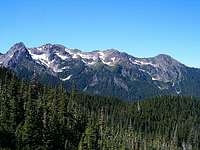
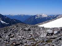
For whatever caused my internal pain, it thankfully did not regress during the night. I was now in good shape to tackle the Cascade Pass Trail seven miles farther down the road. I handled the pits and bumps to get there, and I crossed into the national park just before the trailhead. The trail ascends via innumerable switchbacks up the very steep north slope of the Cascade River valley. It amazed me how the forest grew on such a steep slope and cool climate, but silver firs seem to thrive in such conditions with plentiful moisture. My increasingly aerial view of the valley was fun to follow at each successive switchback. As the trail finally leveled, I pursued a direct route southeast to the pass. I was about at the tree line, and the trail was now an uneven platform of rocks set into the steep valley wall. Cascade Pass itself beautifully overlooked the top of the Stehekin River’s headwaters. I could now see some of the adjacent peaks outside of the Cascade River valley for the first time. Sahale Mountain was just to the northeast, accessible by a spur trail.
After that level approach, the spur trail to Sahale began with a contrasting steep climb up a talus slope. I then hiked back west toward a protruding ridge, which arcs like a hook south from Sahale. After the talus levels out a little bit, the trail straddles the arc-shaped ridge to the mountain. This path was the gateway to what must be the most dazzling alpine meadows anywhere. The kaleidoscope of color featured yellow tiger lilies, vivid red paintbrush, white and purple saxifrages, and dozens of other flowers that I cannot name. In a chaotic land full of vertical cliffs and steep rock faces, these flowers flourish on the flatter areas. The two aspects combine to create an environment fit for postcards.
![Sahale Wildflowers]() Wildflowers near Cascade Pass. Wildflowers near Cascade Pass. |
![Sahale Mountain]() Sahale Mountain lying ahead of me. Sahale Mountain lying ahead of me. |
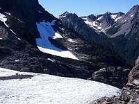
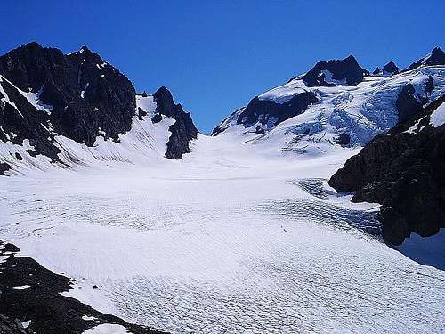
Farther up the spine of the ridge, I passed by a marmot admiring the wildflowers along with me. About at that point, the incline intensified once more and the meadow plants disappeared behind me. I was now on the proper south slope of Sahale Mountain. The trail indiscriminately blended into the talus rocks and left me to determine my route. There was a prominent slope of rocks clear of the snow bunching around me. I used that slope all the way to the Sahale Glacier, where I stopped to satisfy my grumbling appetite. The glacier marked the end of my hike, as it was again too risky to attempt glacial travel without the proper equipment. But it was a brilliant roadblock to see, as the surface snow was colored dark pink by algae. I could accurately say that I had never seen anything like it before, but that thought was becoming redundant here in the Cascades. I grabbed a fascinating souvenir rock at the glacier and set about my meal.
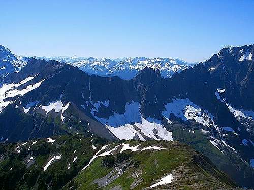
Another hiker was already at the glacier’s edge eating her own snack, so I talked to her for a while and we shared the views together. High on the mountain beyond 7000’ elevation, I could now see the amazing Cascades stretching to the southern horizon. The peaks and ridges appeared sharp to the touch, with the edges cutting and slicing into the skies at all angles. The meadows from here looked like a green carpet draped over the black rock, and there was no cloud in sight. It was simply a breath-taking scene, which I was in no hurry to leave. On a trip full of amazing places and hyperbole about them, I truly believe this was the most amazing vista I have ever been blessed to see.
![Sahale Glacier]() Beautiful colors in the Sahale Glacier. Beautiful colors in the Sahale Glacier. |
![North Cascades]() My most lasting image from the North Cascades. My most lasting image from the North Cascades. |
The most memorable trait about the girl I dined with at Sahale Glacier was her speed on the trail. I could not have kept up with her even in my best efforts, at least not without falling and injuring myself repeatedly. On the way down the Sahale ridge, I passed by presumably the same marmot I met earlier and several scuttling pikas. I admired the flowers a little longer and stopped for a look at Doubtful Lake, at the bottom of a steep depression above the pass. Once back across Cascade Pass, I moved pretty steadily to the parking area below the towering snow-streaked face of Johannesburg Mountain. Another hot meal sounded pretty enticing after a long day on the trail, and I found it in Marblemount. Once I licked my plate clean, I found the Goodell Creek Campground farther east on the North Cascades Highway. It was my resting place for the night.
![Cascade Pass]() My departing view from Cascade Pass.
My departing view from Cascade Pass.I woke up and soon packed my tent, like any other typical morning in my travels. But I did so dreading what was to soon follow. I knew I needed to give myself a wash, particularly my hair. It was about forty degrees outside and the available water was the same temperature. I hesitated a while, but I was ultimately able to push through with quite a painful cold water wash and rinse. I neglected a long and toasty drive behind the heater, instead moving right across the highway to the North Cascades Visitor Center. The center had some interesting displays inside and some relatively short developed trails outside. The informative trails posted notes about the old-growth cedar and fir trees towering around me. Occasionally a break in the canopy allowed the morning sunlight to filter through to the bright green ground plants. The Loop Trail led to the banks of the Skagit River and its very swift waters. Despite my proximity to the visitor center, I hardly encountered other hikers. It was a great little area to chill out and take in the scenery.
After my time on the trails and in the picnic area for lunch, I resumed my eastbound journey along the North Cascades Highway. Inside the Skagit River valley, there are several nice views of lakes and glaciated peaks. The byway twists and turns, rises and falls, and stretches for a long distance through mostly undeveloped country. This distance really caught me unprepared after I chose not to purchase gasoline in Marblemount. I was past midway through the drive when I realized, if there was no station at the tiny town of Mazama, I would be resigned to bicycle transport. The downhill grade after Washington Pass, the highway’s highest point, really helped me out. I coasted for about five miles in neutral toward the Methow River valley, where I found a station. I had my gasoline, the most expensive seen during my trip, but I now also recognized a new problem lurking within my budget. After some coarse arithmetic involving my remaining money and remaining miles ahead, it became apparent that I could not do much more than drive home.
My plans for the day were sort of unspecified to begin with. I was just going to approach Montana and see what came to me. Now I was worried about doing much of anything that involved money, both today and for the remainder of my trip. I worked my way east through part of the Okanogan National Forest to the Coulee Corridor Scenic Byway and the colossal Grand Coulee Dam. I continued into the Spokane River watershed, still just taking in the sights from my car and heading east. At an interstate rest area in the Idaho panhandle, I decided to park for the day. It was still daylight when I stopped, so I passed a good amount of time reading and waiting for night. Once I finished the book, boredom set in and I drove another hour in the early night to the Montana state line. Along the way, I studied my options for the remainder of the trip, but reached no definitive conclusions. At Montana’s first rest area is where I ultimately awaited the next day.
Return Through Glacier National Park, Montana
![Loop Overlook]() Along Glacier National Park's Going-to-the-Sun Road.
Along Glacier National Park's Going-to-the-Sun Road.![Reynolds Creek Channel]() Water channel carved by Reynolds Creek.
Water channel carved by Reynolds Creek.I was still quite unsure about where to go next with my limited finances. Since Glacier National Park did not appear to be much of a detour from a straight line home, I left the rest area and soon turned north toward the park. I saw pristine sections of the Lolo National Forest and Flathead Lake in the early sections of my drive, but nearer to Glacier I was slowed by several towns presumably crowded with other tourists. After plodding my way through these developed areas, I eclipsed the west boundary of the national park and stopped at the Apgar Visitor Center. I acquainted myself with some brochures and then set out for the continental divide at Logan Pass.
Getting there was going to be most of the fun in this case. The park’s west-east route, Going-to-the-Sun Road, just has a name that brings intrigue. The road parallels the Lake McDonald shore for ten miles before beginning its climb toward the divide. Once I reached an area called The Loop, the bends tightened and the lanes seemed to narrow. Walls of rock closed in from the north, and on one occasion, dumped a falling rock on the roof of my car. It sounded significant but I could not find any dents or scratches later. The views from this point forward were really tremendous. This terrain was a showcase of the sculpting power of glaciers over time, which is what gives the park its name. The ridges cutting into the sky are sharp and steep with noticeable layers of rock. I began to stop often, both for road construction and my own discretion. The views along the road were almost exclusively south-facing, so the midday sun made photographs difficult. I needed to hike a trail along Logan Pass to hopefully capture some good images.
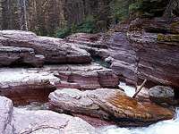
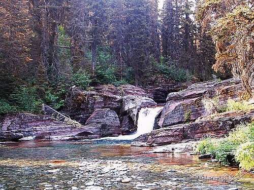
Many others must have had the same idea. It was late afternoon at this point, and Logan Pass was completely full. I circled around for several minutes, along with several other cars, but a parking place never materialized. I was disappointed but I had to move on to the next available access point along Going-to-the-Sun Road. That came at Jackson Glacier Overlook. In addition to the view of the glacier, one of the few remaining within the park, the overlook harbors a couple of trailheads. I first checked out the cluttered trail northbound to Piegan Pass, but I ultimately started south on the more manageable Gunsight Pass Trail. This trail was eerily quiet for the first mile. I clapped and yelled frequently to decrease my chances of a bear encounter, but I heard little else until I neared Reynolds Creek. The familiar sound of rushing water intensified as I hiked my way down the slope. When the creek became visible, I hacked through the vegetation to reach it, and I gazed at a gorgeous natural site. A beautiful barricade of purple rock sat behind a level section of the creek, and Deadwood Falls cascaded down through a small notch in the rock. I walked upstream a little bit for a souvenir rock, along some of the uppermost reaches of the Hudson Bay watershed, but I returned to relax by the falls that struck me so much. In only one afternoon, I was unable to give this park its proper attention, but I was thrilled to take one everlasting memory from my abbreviated visit.
|
|
| Deadwood Falls on Reynolds Creek, part of the Hudson Bay watershed. |
As I went east from the Jackson Overlook Trailhead, I filtered through my camping options to decide where I would be sleeping tonight. I really needed to sleep at no cost, but it was too late in the day to start the backcountry camping process. At this stage, that meant I would end up sleeping in my car. I exited Glacier National Park on the narrow land corridor between the upper and lower Saint Mary Lakes, and I crossed the sudden threshold from mountains to plains. The Rockies here rise almost immediately from the level plains lying to the east; it is really something. I watched the silhouette of the range fade along with the sunset in my rearview mirror. A bright moonlit vastness of the plains was my only company for the next few hours. Late at night, when I had grown weary, I eventually stopped at a roadside rest area in Lewistown, Montana.
Day Fifteen & Sixteen return 090911-091011
Once I untangled myself from the backseat blankets, I resumed my eastward route in earnest. My morning was spent within the wide open spaces of the northern plains, neglecting the parks of the western Dakotas because I could not afford to detour to them. I did sacrifice a couple of dollars in Wall, South Dakota, just so I could buy ice cream from a place other than Wall Drug. The highway signs for Wall Drug were pleasant at first, but after literally sixty of them in sixty miles, I was annoyed with the place. So I gave some ice cream business to a competitor. Afterwards, I napped at a South Dakota rest area before bringing the venture to a conclusion about three days prematurely. I ended up having about fifty dollars remaining, which seemed like a very tight margin when I still had two thousand miles to cover. I should have allocated more money in my budget, obviously, but I am glad I was able to fully visit the core destinations of my trip in Oregon and Washington. That alone made this trip to the Pacific Northwest a wonderful success, regardless of the truncated end.


Comments
Post a Comment