
|
|
Route |
|---|---|
|
|
40.77640°N / 110.37295°W |
|
|
Hiking |
|
|
Summer |
|
|
A long day |
|
|
Class 3 |
|
|
 South Kings and Kings Peaks
Overview
The Kings-Emmons ridge extends south from Kings Peak (13528') the highpoint of Utah to Mount Emmons (13440') Utah's 4th highest peak. In between are five other 13000 footers, S Kings (13512'), Painter Peak (13387'), Trail Rider Peak (13247'), Roberts Peak (13287'), and N Emmons (13068'). South of Emmons is another 13000 footer, S Emmons (13170') for a total of eight 13000 footers in a ridge spanning 7.5 miles. Being the state highpoint makes Kings Peak extremely popular and several groups of people can be found ascending its slopes every day in the summer, but the other peaks are seldom climbed.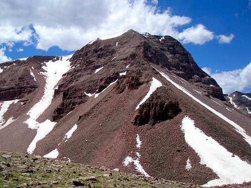 Painter Peak Painter Peak |  Roberts Peak Roberts Peak |
Logistics make it tough to do the whole ridge in one trip. This page describes a route that encompasses the four northern peaks of the ridge, Kings Peak, S Kings Peak, Painter Peak, and Trail Rider Peak. It is especially suited for those who prefer to travel long distances lightly loaded vs backpackers. The route can be done in one long day or as a multi-day trip that minimizes the amount of steep vertical gain carrying overnight gear.
Stats
| Peaks Climbed: | Kings Peak (13528'), S Kings Peak (13512'), Painter Peak (13387'), Trail Rider Peak (13247') |
| Start/lowest Elevation: | 9400' |
| Highest Elevation: | 13528' |
| Total RT elevation gain: | 6165' |
| Total mileage: | 29.12 miles |
| Trail mileage: | 21.54 |
| Off trail easy miles: | 1.61 |
| Off trail boulder hopping/scrambling miles: | 5.97 |
Getting There
See the Getting There section for the main Kings Peak page.Route Description
OverviewStart at Henrys Fork Trailhead. Hike on an easy to follow trail to Gunsight Pass. Contour around the base of Dome Peak to the base of Kings. Head up the side of Kings to the summit. Traverse south on the ridge hitting South Kings, Painter Peak, and Trail Rider Peak. Descend Trail Rider Peak's east ridge to Trail Rider Pass. Make your way partly on a trail and partly cross country back to Gunsight Pass and retrace your steps on the trail back to the trailhead.
Henrys Fork Trailhead to Gunsight Pass
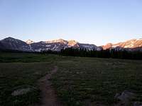
The trail starts at the south end of the parking lot by the signboard and picnic table. Hike south on the trail to Elkhorn crossing which is about halfway between the TH and Gunsight Pass. This section of trail is mostly wooded with few views. There is a foot bridge here across Henrys Fork as well as a wider, shallower spot for horses to cross.
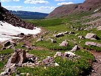
Cross the bridge and continue on the trail to Gunsight Pass. Just past the crossing, the trees open up and you will get great views of Gunsight Peak, Dome Peak, Kings Peak, Henrys Fork Peak, and Mount Powell. On the stretch between the bridge and Gunsight Pass, there are several wet muddy sections. The mud does not dry up until late in the summer. The trail is an oozey brown mess in places but you can always avoid the worst of it by tromping through the brush.
 Dome, Kings, Henrys Fork, and Powell Dome, Kings, Henrys Fork, and Powell |  Mount Powell Mount Powell |  Muddy mess of a trail Muddy mess of a trail |
Gunsight Pass to base of Kings
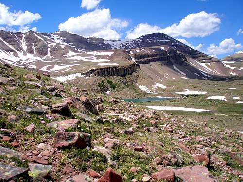
The peaks on either side of Gunsight Pass are Gunsight Peak (13263) to the northeast and West Gunsight/Dome Peak (13103) to the southwest. There are several ways to get to the summit of Kings from the pass. The way described here is the easiest and the most commonly taken. Shortly west of Gunsight Pass you should be able to find an obvious path leading west where many hikers have trod before you. Follow the path until it ends in a rocky area and scramble up the rocks to the top of the plateau south of Dome. Once you get to the top of the plateau the terrain levels out and is a gentle grade up and then down until the base of Kings. Just make a beeline for the base. Nice views of the Kings-Emmons Ridge will be had to the south.
 Gunsight Traverse Gunsight Traverse | 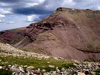 At the start of the traverse, looking back at Gunsight Pass and Gunsight Peak At the start of the traverse, looking back at Gunsight Pass and Gunsight Peak |  Crossing the plateau, Emmons to Painter Crossing the plateau, Emmons to Painter | 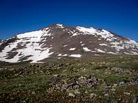 Kings Peak Kings Peak |
Base of Kings to Kings summit  Nearing Kings Peak summit Nearing Kings Peak summitIt is quickest to just go up the side of Kings Peak. It is a straightforward boulder hop to the top. Some people go to Anderson Pass north of Kings Peak and then follow the ridge S to the summit. |
Kings to S Kings
From the summit of Kings you head south along the ridge. The terrain along the ridge is a much gentler grade than ascending the side of Kings. It is primarily a time consuming boulder hop on stable rocks. There are no easy walking grassy areas and no water was to be found even with snow melt in full swing. It is .8 miles to S Kings. You will lose 488 feet of elevation and gain 472. S Kings was once thought to be the highpoint of Utah and has an easy to find benchmark located at N40 45.953 W110 22.672.
 Heading to S Kings Heading to S Kings | 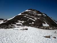 Almost at the summit of S Kings Almost at the summit of S Kings |  Looking back at Kings Looking back at Kings |
South Kings to Painter Peak
There is a subpeak (13306') along the way to Painter Peak. Although some people consider it to be a 13000 footer, it only has 86 feet of prominence. It is directly on the way, so you will go over the top of it too.
The crest of the ridge from 13306 to Painter Peak is interesting as it consists of flat slabs raised up about 10 feet or so from the surrounding terrain interrupted by a few deep clefts to step across. A more daring individual or someone with longer legs could perhaps stay on top the entire way, but I had to scramble down to the west a couple of times.
Looking to the east you will see Val Benchmark, the dividing line between Painter Basin and Atwood Basin. To the southwest lies Yellowstone Basin.
 Looking S to Painter Peak, the next objective Looking S to Painter Peak, the next objective | 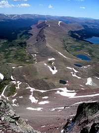 Looking E to Val Benchmark Looking E to Val Benchmark |  Looking SW to Yellowstone Basin Looking SW to Yellowstone Basin | 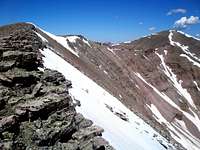 Looking back at S Kings Looking back at S Kings |
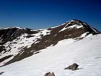
Painter Peak to Trail Rider Peak
Descending from Painter Peak was the easiest terrain on the ridge. You will get a good look at Trail Rider Peak on your descent and have a clear view of its east ridge that you will be taking down to Trail Rider Pass. At 362 feet, the uphill to Trail Rider Peak is the smallest of the trip. In the picture on the left below, your descent route is shown as the ridge going diagonally down and left from the top of Trail Rider Peak.
 Looking ahead to Trail Rider Peak
 Looking back at Painter Peak
Trail Rider Peak to Trail Rider Pass
Doing the whole Kings-Emmons ridge in one day is a nice thought, but would require a car shuttle of over 180 miles even though the trailheads are only 21.3 miles apart. Trail Rider Peak is the last peak on the ridge where you can conveniently return to Henrys Fork. If one were to continue on down the ridge, the next peak up would be the triangularly shaped Roberts Peak.
The descent down the east ridge of Trail Rider Peak is the most difficult terrain of the day. The boulders are big and require some hand use getting down. It is slow going. I walked on some snow part way but when I started sinking in to my thighs went back to the boulders. Early in the season there will be a cornice on the east side of Trail Rider Peak and the first 10 feet down could be difficult if the snow is not soft.
 On Trail Rider Peak, looking down to Trail Rider Pass On Trail Rider Peak, looking down to Trail Rider Pass |  Looking SE to Roberts Peak Looking SE to Roberts Peak | 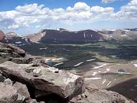 Looking ahead to Gunsight Pass and Gunsight Peak Looking ahead to Gunsight Pass and Gunsight Peak |  Near Trail Rider Pass, looking back up at Trail Rider Peak Near Trail Rider Pass, looking back up at Trail Rider Peak |
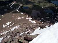
Trail Rider Pass to Gunsight Pass
The trail from Trail Rider Pass to Painter Basin below is distinct and easy to follow. Once at the base however there is no worn dirt path, only an occasional cairn. I've lost the cairns after a short distance 2 out of 2 times and just made my way cross country to the Gunsight Pass Trail. Although there are several swampy areas marked on the map I didn't find any to be a problem even in early July. It is easy cross country low vegetation terrain.
There are 3 stream crossings that could be interesting early in the season. The first is fast, deep, and narrow and can be jumped. The second will require your feet getting a little wet but the water won't be over your boot tops. The third just requires a little scouting.
Once you reach the Gunsight Pass trail, simply follow it north to Gunsight Pass. Most of the way it is distinct, but there are a few spots where it has faded away.
 Looking ahead to Gunsight Pass Looking ahead to Gunsight Pass | 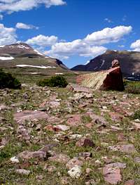 An occasional cairn An occasional cairn |  The first stream crossing The first stream crossing | 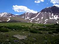 Looking back across Painter Basin towards Trail Rider Pass Looking back across Painter Basin towards Trail Rider Pass |
Gunsight Pass back to the trailhead
Upon reaching the pass just follow the trail back to the trailhead.
 Looking ahead toward Henrys Fork Looking ahead toward Henrys Fork | 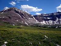 Looking back Looking back |  The bridge The bridge |
Mileage and elevation gain/loss chart
| Running total | From previous point (in feet) | |||
| Mileage | Loss | Gain | ||
| Trailhead | 0 | |||
| Elkhorn Crossing | 5.25 | 0 | 920 | |
| Gunsight Pass | 9.71 | 0 | 1568 | |
| Kings Peak | 11.46 | 100 | 1740 | |
| S Kings Peak | 12.25 | 488 | 472 | |
| Painter Peak | 13.73 | 540 | 415 | |
| Trail Rider Peak | 14.67 | 502 | 362 | |
| Trail Rider Pass | 15.68 | 1487 | 0 | |
| Gunsight Pass | 19.41 | 560 | 688 | |
| Trailhead | 29.12 | 2488 | 0 | |
Time needed
Obviously, a 29 mile hike over routh terrain with elevations over 13000' with over 6000' of vertical gain will take the whole day unless you are super human. It took me about 4 hours to Gunsight Pass, 5:50 to Kings, 8:50 to Trail Rider Peak, 12:30 to get back to Gunsight Pass, and just under 17 hours to get back to the car.Camping
There is a nice but small (4 site) campground at the trailhead. It is free but there is no water available.If you choose to do the hike in multiple days, then I would advise camping someplace on the north side of Gunsight Pass so that you won't have to go over the pass twice carrying all of your gear. There are numerous spots in Henrys Fork suitable for camping.
When to Climb
The best time to do this route is mid July through mid September. In 2009 I did it on July 7 and encountered almost no snow. I would not recomend this hike on snow in the late spring/early summer because it is so long that the snow will be quite soft and the going will be painfully slow. See this log for one horror story.Essential Gear
Nothing special is needed, except if you do it towards the early side of the season you will encounter a cornice when descending from Trail Rider Peak and might prefer an ice axe for just a few feet.Map
 Route map