
-
 4781 Hits
-
 89.01% Score
-
 28 Votes
|
|
Mountain/Rock |
|---|---|
|
|
42.06483°N / 109.76851°W |
|
|
Scrambling |
|
|
Spring, Summer, Fall, Winter |
|
|
7222 ft / 2201 m |
|
|


Overview
If you have a hankering for places that truly are out in the middle of nowhere, the Pinnacles will delight you, for they are in the middle of the middle of nowhere.
Deep inside the Great Divide Basin, around which the Continental Divide actually splits, meaning water that falls in there either soaks into the ground or evaporates-- there are no outlets-- the Pinnacles, with their many summits, beckon to those who have an insatiable need for solitude, wilderness, and remoteness.
The Pinnacles are a collection of buttes rising from a desert floor of sand and sage. Each seems to be some kind of cross between a badlands butte and a small mesa. With one notable exception-- the highest of the peaks, actually-- the summits are small. Because the peaks are close together and not terribly high (the highest rise no more than 300’ from their bases), it is possible to climb all of them in a day. They range from Class 2 walk-ups to easy Class 3 scrambles.
Not much else of geological note is very close; the nearest major formations, those of the South Pinnacles, are about three miles away. There is thus an incredible sense of vastness and isolation out here. Far to the north, the Oregon Buttes and the Wind River Range look like lonely outposts of a distant land.
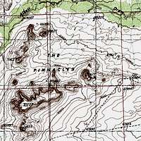
When you look at The Pinnacles USGS quad, you at first may think that the pinnacles are so steep as to be unclimbable. However, notice that the contour intervals are 10’ each. I climbed all the major peaks here (except, ironically, the highest, which looked both easy and boring), and not one of them was difficult.


Getting There-- Before and After Parking
The getting there is more complicated than the climbing, and that is why this section is much more developed than any of the others. You can get most of the way in a passenger vehicle, but unless you have high clearance and 4wd, you will have to hike the last three miles of the driving approach.
Do yourself a favor and have (and use) a good area map if you head out here. While my directions will get you to the Pinnacles, it is much better if you have a map to complement them. I use the DeLorme Wyoming Atlas and Gazetteer, and I have found it helpful for showing junctions and where the roads go.
 |
 |
From South Pass on WY 28, head south on Oregon Buttes Road, which is suitable for passenger cars when dry. Approximately 27.5 miles from South Pass, Oregon Buttes Road ends at Bar X Road (signed as County Road 21), also suitable for passenger cars when dry. Here, you are on a rim, and if you walk to the edge, you can see the Pinnacles in the basin below.
Turn left on Bar X Road and drive 3.5 miles to another junction. Here, Bar X Road goes left. You want to go right (this short road rejoins Bar X Road in less than two miles, but in 2010, I found an eroded section that I did not want to take on even with high clearance, four-wheel drive, and skid plates). This junction is just after a drainage crossing (probably dry) and a small pond (also probably dry) that may have been created for livestock use, as the ruins of a ranch (maybe Bar X Ranch) are nearby.
You will park 0.5 mi along this road by the remnants of a ranch. Just north of the ranch, notice a faint track heading west; it is at the spot marked “6836T” on the USGS The Pinnacles quad, and the map shows the “road.” That is where you go next.
 Ranch Ranch |
 Road Road |
The rest of the way, you need at least high clearance. Although I did not need 4wd, I stayed in 4-High in case I drove across some ground that was softer than it looked. The track is usually pretty easy to see, but sometimes sagebrush and other desert plants obscure it. If you are obsessed with your paintjob, don’t drive this road; the plants will often brush the sides of your car, and sometimes you have to crash through headlight-high growth.
Also, don’t even think of going out on this road when it is wet. The surface is mostly dirt and hardened mud, and you are asking to get stuck, even with 4wd, if there is significant precipitation. If it begins to rain while you are out here, turn around or get back to the car and get out as fast as you can.
Note: Do not be fooled by a track heading west 0.2 mi after you leave Bar X Road; it is where the road makes a 90-degree bend southeast. That spur, which is not shown in my DeLorme atlas or on the USGS quad, dead-ends at 1.7 mi.
Back to the approach-- after 0.7 mi, there is another, better-worn road going off to the left. Do not take it; it leads southwest to an area known as South Pinnacles, which the BLM did not recommend for wilderness designation due to oil and gas potential.
About two miles in, there is supposed to be another junction, at “6888” on the quad. The right fork leads closer to the Pinnacles than my approach does, and it rejoins the track about half a mile west of where I parked. However, I never saw this fork as I headed in. I did, though, come across the road as I hiked north to the Pinnacles, and I could see where it rejoined my road, so perhaps more-observant eyes will spot the eastern end of the track and thereby save some walking distance.
I parked at 3.2 miles in, right around the spot marked “6954” on the quad, and hiked north across easy terrain for 0.7 mi until I was at the base of the first of eight “peaks” I climbed that day, Point 7161T. The highest of the Pinnacles is Point 7222T.
 |
 |
 |
The southern end of Bar X Road is at Exit 152 on I-80, the Table Rock exit. From there, it is 37.5 miles to where I left Bar X Road. Most of this drive is through featureless country marked by occasional oil/gas operations, but herds of wild horses may keep your interest.
The western end of Bar X Road is on WY 28 around 20 miles southwest of South Pass. It appears to be around 33 miles on Bar X Road from WY 28 to the junction with Oregon Buttes Road.
In Wild Wyoming, author Erik Molvar describes some hikes into the Pinnacles area from a spur near the western end of the area, accessed from Bar X Road.
There are many other ways to approach the area by road, too many to list here. Using a good road atlas, as recommended already, is the best way to discover and figure out these approaches.
Red Tape and Camping
No red tape beyond respecting vehicle restrictions and the occasional stretch of private property.
A word of caution, though-- have a good spare and enough food and water to spend at least one extra night out if you have weather or mechanical problems. This part of the Great Divide Basin does not see a lot of traffic, and it is a terrible place to be stranded. If you do have to hike out, it is probably better to head south on Bar X Road even though it is longer to pavement that way. The southern half of the Great Divide Basin sees a fair amount of industrial traffic, and that southern half is much closer to the Pinnacles than South Pass is, so you are more likely to find assistance faster going that way.
No campgrounds out here, but you can camp pretty much anywhere. Avoid washes and other low places in case of flash flooding.