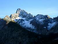
I Followed Baron Creek for about 5 miles and left the trail. Headed up into bowl on the northwest side of Tohobit. This would be a great area for a base camp. From this area, there are great views of the cascading Baron Creek Falls. Some snow still remained on the flanks of Tohobit and the there's a permanent snowfield under the vertical north face (marked on the USGS map).
I kicked steps in the snow and made a frightfully steep climb up snow to a notch on the west side between Tohobit and Point 9389. Luckily I had my Ice Ax, but it was still tough duty on my leather boots. I knew later on I would not be descending down this steep snow couloir- there was nothing to rappel off of and the rock was smooth and vertical around this area. When I reached the notch, the south side was completely dry. From here it was trial and error as I made a very difficult traverse up and down sheer rock pinnacles and gullies trying to get to the summit. Many times I thought I was about at the summit (it was never visible) and it was still several hundred feet down and up another gully. I must have climbed and descended an extra 1500 feet making my way up and down this complex mountain. Finally, some Class 4 scrambling brought me up the true summit and upon two mountain goats, not 10 feet away. They seemed as startled and surprised to see me, as I was them. The summit contained a canister from the Angeles chapter of the Sierra Club. There were only a few signatures from about 15 years.
![Tohobit Peak]()
At this point I needed to figure out how to get down. The steep snowfield was not an option, neither was the vertical north face, so I decided to descend south into the trailless Goat Creek drainage. I wouldn't recommend this retreat unless you enjoy rappelling off small trees and wobbly rocks into gushing water etc. There were many short easy rappels at first that just were more time consuming than anything else. I attempted to get to a main gully that I spied and I did one long rappel off perfectly vertical and featureless rock. Unfortunately, I reached the end of my rope still 50 above the gully and with nothing nearby to set up another rap anchor. I had also used all of my rap slings. I swung wildly from side to side at the end of my rappel desperately looking for something…anything to rap off of. I finally "settled" on a manky flake of rock that might hold me. I was desperate and wouldn't wish this circumstance upon my worst enemy. It would be too difficult to prusik up my rope to the previous rap anchor and it was getting dark. I looped my rope over the flake, prayed and made the questionable rappel. I reached the gully and scrambled down reaching what looked like one more rappel right through the heart of a waterfall. I made this wet and cold rappel and the rope snagged and would not pull. It was about dark and there was no way I was ascending a slippery waterfall at this point. That rope is probably still there now.
![This is a rare view of the...]()
I finally reached the Goat Creek drainage and made a very tough bushwhack by headlamp over logs and bushes, soaking wet, tired, and minus a rope. I eventually reached the trail along the South Fork of the Payette River and was on cruise control about 1 mile from the trailhead when my headlamp went out. No, this was not the batteries, it was the bulb. I didn't have an extra bulb and there was no moon and I was in trees. It was dark-real dark-like the kind of dark where you can't see your hand in front of your face. I ended up using my hiking pole to tap the trail like a blind man and go by the feel of the surface of the trail. The last mile took about 1.5 hours and I reached my car at 3am. I since have sold that headlamp, and now use an LED type that has 4 bulbs in it with a life expectancy of 7+ years for each bulb.
Updated Note on this TR 10/8/08: I look back on this report and cringe at how "green" I was at the time that this occurred. If your experienced, like I am now, this scramble should be no more than a Class 3-4 trip with some route finding along the way.


Comments
Post a Comment