
-
 16617 Hits
-
 90.22% Score
-
 32 Votes
|
|
Mountain/Rock |
|---|---|
|
|
44.09100°N / 115.066°W |
|
|
10046 ft / 3062 m |
|
|
Overview
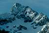
Rarely climbed and often hiked past, Tohobit peak sits along the very popular Baron Lakes trail from Grandjean to Baron Lakes. Although the approach to the base is easy, the route to the summit is not.
From the Valley floor to the summit is nearly 4,000 vertical feet in less than a mile and a half distance, with the easiest route to the summit being class 4 scrambling with some rather complicated route finding at times.
 |  |
Getting There
Travel North from Boise on Hwy 55 to Horseshoe Bend, then to Lowman on Hwy 21and continue past Lowman for 25 miles. Turn Right at sign for Sawtooth Lodge and continue for 6 miles on very good dirt road. At Grandjean, take left fork to the hiker's/horse trailhead and campground area. There is a very nice camping area and small store at Sawtooth Lodge--Bring your 5th wheel trailer, you'll have a lot of company as this is a popular camping area with small cabins and a geothermal swimming pool.
North Side access:
From the trailhead hike South along the Grandjean trail for 1 1/2 miles until it reaches the South fork of the Payette river. Take the Baron creek fork to the East and continue up the trail for approximately 3 miles, cross the North Fork of Baron creek (very good log crossing, or wade) and continue for another 1 1/2 miles to Moolack creek.
The North face is just visible above the trees, find a suitable place to cross Baron creek (this can be VERY difficult during spring runoff) heading south through steep forested slopes to a broad permanent snowfield at the foot of the mountain.
Either continue up the snowfield to the North face, or begin scrambling along the Northwest ridge to the summit.
South side access:
From the trailhead hike South along the Grandjean trail for 1 1/2 miles until it reaches the South fork of the Payette river. Cross the South Fork of the Payette river (this may be impassable during spring runoff) and continue along the trail toward Elk Lake for approximately 1 mile. Leave the trail and head East at the first major drainage system (Goat Creek) and continue cross country up the creek drainage for 3-4 miles to the base of the mountain. Choose any number of the 100's of scrambling options to the west ridge--excellent route finding skills are very helpful.
 |
Red Tape
Self issued wilderness permit at trailhead. No parking fee is required as of 2005.
When To Climb
April-October
Access onto the Grandjean road is a major factor as when to climb, it is not maintained before Memorial weekend and after Labor Day. Late season climbs are dictated by winter storms.
***They don't plow snow from the Grandjean road, so travel early and late in the year at your own risk***
Early season climbs are best in April and May to optimize snow/ice conditions, but may be stopped due to spring runoff and the rivers/creeks impassable.
Camping
Camping in this area is EXCELLENT!!
Sawtooth Lodge has rustic cabins(emphasis on rustic),a small store and a geothermal swimming pool. There are trailer sites with hookups and tent sites. There is also a very nice primitive hotspring about 1 mile from Sawtooth Lodge (Sacajawea hot springs) on the banks of the SF Payette river.
A campground is located at the trailhead, with drinking water, pit toilets and horse facilities. Campgrounds are also located between Lowman and Grandjean on Hwy 21.
Camping is also permitted on National Forest property in many primitive sites along the South Fork of the Payette river near Grandjean.
Camping outside of designated campgrounds is NOT permitted in the area from Lowman to Grandjean
Mountain Conditions
General weather/snow/road conditions can be obtained at:
www.sawtoothlodge.com
Boise ... (Oct 16-May 14) ... (208) 344-2437
Grandjean ... (May 15-Oct 15) ... (208) 259-3331