
-
 12320 Hits
-
 78.27% Score
-
 9 Votes
|
|
Area/Range |
|---|---|
|
|
13.80000°N / 89.5°W |
|
|
7812 ft / 2381 m |
|
|
Overview
This park is part of an area declared as a priority for conservation. It has an area of about 6300 acres, formed primarily by government lands (national and municipal) and some private interests. The main peaks are Ilamatepec or Santa Ana Volcano, Izalco and Cerro Verde; they have altitudes range from 500 to 2380 meters above sea level. On the slopes of these magnificent mountains, you can find populations with ethnic heritage and colonial structures.The climate is cool; with an average temperature of 6° to 8° C (42.8º to 46.4º F) less than San Salvador, but this is variable. Some days, it is quite warm; other days the temperature suddenly drops.
The Park is filled with a diversity of natural habitats: mist forests, desert of height and vegetation on lava; also bare lava and the sulfur lagoon of Ilamatepec. There are others like: forestry plantations, coffee, grazing areas, and other crops. The cypress trees in forestry plantations grow to 40 m high and 6 m in circumference. Trees in the mist forests provide habitats for a variety of plants such as orchids, bromeliaceous, mosses, ferns and cactus.
Interesting Places
Ilamatepec or Santa Ana VolcanoThe summit! On top of the tallest volcano in the country, you’ll be surrounded by the high plateau and dwarf forests. This combination of pastures, sparse bushes and gigantic maguey plants make this a unique landscape in all of Mesoamerica. Feel the heat of the volcano’s enormous, boiling crater lake. This aquamarine pool is over 300 meters (984 ft.) deep.
 Santa Ana Volcano
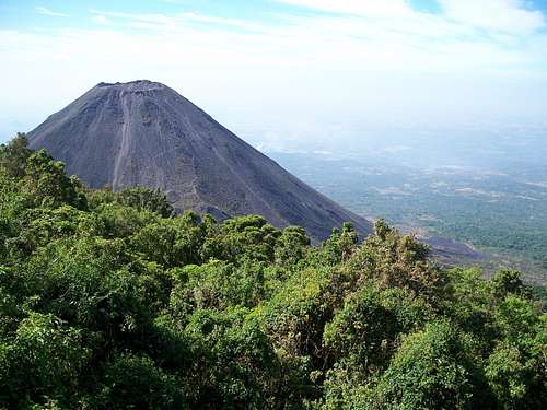
Izalco
Izalco Volcano (1,952 m. (6,404 ft.) above sea level)
Historically, the Izalco Volcano had been known as the lighthouse of the Pacific. For 160 years its eruptions provided a beacon to ships crossing the ocean at night. It’s also one of the youngest volcanoes in Latin America, born in 1770.
 Izalco
Cerro Verde
While you hike along the wooded trails of Cerro Verde keep your eyes open for abandoned coffee bushes, the silent testimonies of the country’s golden days of coffee production. As the mountain forest slowly takes over, more and more animals are calling this place home. Look for colorful birds like the Orange-chinned parakeet and the Green Jay frolicking in the treetops. The Harpy eagle, one of the largest eagles in the world, is also endemic to these forests.
The higher up Cerro Verde you get, the more likely it is to find yourself suddenly wrapped in thick, misty cloud cover. Cloud forests get their name from the effect of horizontal rains. Wispy ferns, thick mosses, exotic bromelias and orchids of psychedelic colors thrive in this cool, wet environment.
 Cerro Verde
Coatepeque Lake
Coatepeque is a volcanic lake situated about an hour from San Salvador. It is much older than Ilopango, though created by a similar catastrophic eruption some five to six thousand years ago. Named Lago de Coatepeque, it is on the eastern slope of the Santa Ana volcano. It is a beautiful, clean, and sparkling blue crater-shaped lake, 6 kms wide and 120 meters deep and surrounded by steep green slopes rising up 250 to 500 meters.
Caluco Town
This colorful town, the smallest in the department of Sonsonate, is criss-crossed by quiet streets where everyone knows their neighbor and children play happily in the afternoons. Caluco is the home of the first church built in El Salvador, however only the ruins remain to this day. You can find the ruins near the central park, home to an incredible number of birds, whose song is oftentimes louder than the cars that pass by!
One of the main attractions of Caluco is Shutecath, the town’s outdoor tourism center, which was named after the thermal river whose source is just 6 km. (3.7 mi.) from the town. Here you will find several small restaurants, all owned and operated by local women, that specialize in preparing the town’s most famous dish, wild hen soup. Take an afternoon to chat with the ladies and sample the variety of local cuisine and snacks they have to offer.
The Plan de Amayo
Great for hiking through tropical and subtropical humid forests with local guides. Here a local group specializes in the cultivation of the Ojushte tree (Brosinum alicastrum), a plant with very high nutritional value commonly used in the preHispanic era.
Getting There
By CarThe Volcanoes National Park is located at km.67 from San Salvador on the road toward Cerro Verde. You can take the highway to Sonsonate (CA-8) through Armenia or the Panamerican highway (CA-1) through El Congo.
By Bus
Take the 248 from the El Congo turn.