Overview
Note: In response to the very scarce amount of information on the internet describing the Desolation Peaks, I have made this page a hybrid Trip Report/Route to describe our experience while trying to clarify and expand on the route information.
Climbing Desolation Peaks truly is an experience. From just about every vantage point imaginable, these craggy peaks seem close enough to grasp, close enough for a side trip, a straightforward climb to some high 12ers. But the Desolation Peaks are deceiving. I climbed Longs Peak in one shot and thought it was easy. I climbed Mummy Mountain in early June while there was still snow on it. I hiked 100 miles and 10000 feet in vertical gain with 60 pounds of crap on my back this summer for fun. It took me three times to climb Desolation Peaks.
Desolation Peaks have two named summits, East and West, and unofficial North peak sitting on the ridge leading down to Flatiron Mountain. North of Ypsilon Mountain, East Desolation Peak at 12949’ is the second tallest 12er (Clark Peak is first at 12951’) in the Rocky Mountain Range, and 5th tallest overall. It is taller than Mt. Richthofen, Mount Julian, and Stones Peak, 12900’s that are well known and climbed. I doubt more than 20 people summit East Desolation per year. Why no one ever climbs these peaks is a mystery to me, they are the some of RMNP’s tallest points, sit on a fun ridge that overlook remote and wild valleys, require a long stretch of class 3 scrambling and class 4 crux to attract some of the more experienced climbers in the area, all while viewing the amazing views of the backside of the Mummy Range.
![Desolation Peaks and lower Mummies]() Our route after a failed 2nd attempt
Our route after a failed 2nd attempt
Hundreds of people climb the CCY route each year, and for the sake of comparison, Ypsilon has 60 entries on the SP log, Chiquita 57, Chapin 45, and Desolation Peaks has 7.
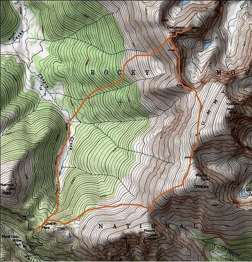
![Desolation Peaks route]() Orange line represents our general route
Orange line represents our general routeTo Point 12718
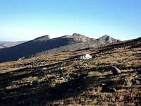
![Mount Chapin]() Looking down from Chiquita
Looking down from ChiquitaFor the most part, the route to the Desolations is class 2 and has well defined route all the way to the Chiquita-Ypsilon saddle, and from there you have a few options. On my first attempt, I decided to gain NO elevation because the saddle I was aiming for was below me, but this would put me on a steep, loose cliff section. With the incoming thunderheads in mind, this is where I would turn around, approximately 1.5 miles from West Desolation. When I finally summited, I climbed up about 150’ up Ypsilon, and what a difference it would make. Not only was I able to completely avoid the broken cliffs, but the terrain was a pleasantly smooth mosaic of tundra and rock all the way to the saddle. This was absolutely not what I was expecting, but I had expected the climb to W. Desolation to be easier than it turned out to be, so it all worked out.
![Intersection on CCY route]() The intersection (I prefer staying on the lower portion)
The intersection (I prefer staying on the lower portion)![The Desolation Peaks]() Familiar look at the Desolations
Familiar look at the Desolations![Early season snow on 12718]() Early season snow on 12718
Early season snow on 12718
Reaching the saddle was quite simple, really, and the views from the saddle are worth the effort even if you do not plan on going any farther. The saddle overlooks a remote valley and small string of gorgeous indigo lakes, while some of RMNP’s larger 13ers sit in the distance. Hagues Peak, Larimer County’s tallest mountain actually looks like something from the backside, something quite different from the bump on a ridge as most people see it from the south. As always, Fairchild Mountain looks taller than Ypsilon Mountain, although Fairchild is 12’ shorter. To the west, the Never Summers sit in their long string, while Mount Richthofen (shorter than E. Desolation!!!) catches the eye. The Cache La Poudre River valley intersects Chapin creek below in a vast meadow, some 2500’ below. Point 12718’ sits along the ridge above us. This area is truly desolate. Point 12718’ is actually 5 feet taller than Hallett Peak, though who really would notice that? There’s a reason I like the Mummy Range more than anywhere else I visit, because of stupid things like that. Not a big deal though, Pt. 12718 is taller than Hallett Peak, E. Desolation is taller than Richthofen, Stones and Julian. But who’s keeping count? Certainly not me.
![At the Ypsilon/Pt. 12718 saddle]() Ypsilon/12718 saddle
Ypsilon/12718 saddle![West face of Fairchild]() Backside of the Mummies
Backside of the Mummies![Cold Morning]() In the shadows of Chapin
In the shadows of ChapinTo West Desolation
![Another Point]() Another point (12755?)
Another point (12755?)![What is THAT!]() What is THAT!?!
What is THAT!?!![East Desolation Peak]() Fairchild and Hagues
Fairchild and HaguesThe ridgeline to West Desolation has a few points on it, and while I am always looking for a new view, I decided to ascend them instead of climbing around them. Atop one of them, I met a little Mountain Chickadee. He didn’t sing or anything, but it was interesting as I’d never seen one at such a high elevation, in fact I rarely see them above treeline. West Desolation looks from afar like a tooth rather than a peak, and it sure doesn’t look very hard to summit. However, when you are right next to it, it looks more like a pile of ‘how the hell do we climb that?’ Indeed, it is neither easy nor straightforward to climb it; you basically have to circle around the base of the block looking for some kind of fissure that will take you to the top. There is a pretty good cairn route up to the top, and the terrain is so sandy there’s practically a trail. The top of W. Desolation is a bit strange; the rocks are dark, glossy and flake off into nice cairn blocks. On the backside far below the summit lies a quite large lake (for being unnamed, anyways) roughly shaped like a trout. Ironically, this lake is too high to hold fish. The views are much of the same, and though a bit smaller than its sister summit; it is still a whole 12918’.
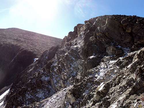
![The scramble to West Desolation]() So the scrabling begins
So the scrabling begins![Peanut break on W. Desolation]() Peanut break
Peanut breakTo East Desolation
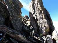
![The granite slab and E. summit]() Granite slab and E. Desolation
Granite slab and E. DesolationThe destination of the trip is really only about a quarter mile away at the west summit, but that’s not to say that it’s an easy quarter mile. A good deal of boulder hopping separates the west summit from the connecting saddle, and because what little route there is takes you in the shadow of larger rocks on the north side, a bit of snow just added to the difficulty. At this point in the year, snow had begun to fall in the area, mostly in small flurries, but the windswept points and verglas point to the fact that September is winter for Desolation Peaks. Anyhow, following the path of least resistance, otherwise known as the only boulder strewn crack that serves as a sad excuse for a path of least impossibility, we would reach the saddle between the two summits before two long. At the saddle, we noted a continuation of the cairn route we followed while climbing the west summit. This route was indeed easier to follow to the saddle, but I wasn’t out to climb East Desolation Peak, I was out to climb the Desolation PEAKS. Plural, as in you climb both, not just one. I hope that the few people who make it that far at least have the decency to climb them both! Give West Desolation its due, I mean, it is taller then your average mountain.
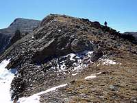
![Interesting scrablimg]() Interesting scrambling
Interesting scrambling![W. Desolation and the Never Summers]() W. Desolation from E. Desolation
W. Desolation from E. Desolation
To my luck, climbing East Desolation was much easier up to the summit block than was West Desolation. The slope is hardly loose at all and would only register a class 2 in my mind until the last 15 feet. The last 15 feet are a solid class 4, mostly because of the decent exposure on your right, a good 100 feet until you hit the sand then another 900 feet of sliding before you hit some solid rocks. Much worse than the Narrows on Longs Peak, but you only have to cross the Narrows, you have to climb the summit block on East Desolation. A few interesting moves and some fancy footwork and you will sprawl out on the very top, 12949 feet above sea level. The views are not much different from anywhere else after Pt. 12718, but they are still quite magnificent. I pulled off my pack, placed a register I made for the summit, and enjoyed the clear blue skies. And I was taller then Richthofen, Julian and Stones, teehehe!
![The route up East Desolation]() Route up E. Desolation
Route up E. DesolationTo Chapin Creek drainage and TH
A great thing to notice when you’re climbing up a 15 foot slab of granite is a good way to down climb it. Of course, I was more interested in just making it to the top then turning back around, so I did not pay attention to good footholds or even how I went up it in the first place. So atop the mountain I had looked at for years and had been turned around twice, I had a nice lunch and thought about how to get back to semi-horizontal ground. It turned out that going down the class 4 section was easier than I had expected, and I didn’t even notice the exposure for whatever reason. Back at the saddle between the Desolations, we picked up the sandy trail/route which was somewhat easier to take back then to follow. I suppose everything seems easier once you get a monkey off your back, though. Once back on solid tundra, we had an interesting option to consider on getting back to the trailhead. We could retrace the route, including regaining all of the elevation we had lost, or we could just drop straight down into the meadow that held Chapin Creek, about 2400’ below us. Recovering from a lingering cold, I opted to drop rather then climb, anyways; we’d enter a new area that neither of us had hiked in.
![Flatiron Mountain]() Flatiron Mountain
Flatiron Mountain![Chapin Creek Drainage and Chapin Pass]() Chapin Creek drainage
Chapin Creek drainage
Unfortunately, the down climb to treeline was a little to steep to be fun, and the mile long stretch of forest to Chapin Creek was of the thick spruce variety. I do not necessarily enjoy climbing over downed timber and slipping in pine needles, but the grade of the hill has leveled off a bit and there were some very well used elk trails for us to follow. When we were finally rid of the trees and entered the meadows created by Chapin Creek, it was apparent that the hiking season was coming to a gradual close. The golden meadow grass had lost its strength and dipped into a permanent wilt, and the willow bushes that ornament the meadows had all but lost every single leaf. Chapin Creek was running a bit high for September, probably a result of the patches of snow higher up and the pleasant sunshine that day. A few little trout had dispersed from their pools when we crossed over the creek and connected up with the trail on the other side of the meadow. A quiet half mile along the trail will take you south to the hill that forms Chapin Pass 400 feet above. All I remember about this hill was that it was the worst hill I’ve ever climbed. 400 feet never seemed so intimidating and relentless. My cold added with my tired legs and wet shoes resulted in my ass being kicked by the time we made it back to the trailhead. At long last, I had defeated the two peaks that had turned me back twice, and I could get on with my list. The Desolation Peaks pushed me to a point that no other mountains had, those peaks pissed me off. That’s when I work best, I suppose, not when I think a mountain is challenging, but when I have decided that a mountain is a bastard. Being a bastard mountain is a good thing though, all of my favorite mountains are bastards, and Desolation Peaks are the best mountains that I’ll never climb again until next year. Seriously, I’ve got to replenish my register sometime next September.


Comments
Post a Comment